
Stoddard County, Missouri - The National Weather Service in Paducah, Kentucky has issued a Special Weather Statement until 3 p.m. Wednesday for Stoddard County, Missouri.
SPECIAL WEATHER STATEMENT UNTIL 3PM CST WED
...A POTENTIAL WINTER STORM WILL IMPACT TRAVEL LATER THURSDAY NIGHT THROUGH FRIDAY NIGHT
... A STRONG COLD FRONT WILL MOVE ACROSS OUR REGION THURSDAY NIGHT. RAIN IS FORECAST TO TRANSITION TO FREEZING RAIN AND SLEET, THEN TO A PERIOD OF SNOW FROM WEST TO EAST.
THE TRANSITION IS EXPECTED TO OCCUR LATE THURSDAY NIGHT INTO FRIDAY MORNING.
DEPENDING ON THE SPEED OF THE STORM SYSTEM, SNOW MAY LINGER THROUGH MUCH OF FRIDAY NIGHT.
THE TYPES AND AMOUNTS OF PRECIPITATION WILL DEPEND ON THE SPEED OF THE STORM SYSTEM. HOWEVER, THE POTENTIAL FOR A HIGH IMPACT WINTER STORM DOES EXIST.
LISTEN TO LATER STATEMENTS AND FORECASTS AS THIS SYSTEM EVOLVES.
Weather provided by Bagby Wealth Management a sponsor of the ShowMe Times.

Stoddard County, Missouri - The National Weather Service in Paducah, Kentucky has issued a Special Weather Statement until 5 a.m. CST on Sunday.
SPECIAL WEATHER STATEMENT UNTIL 5AM CST SUN
...A WINTRY MIX OF PRECIPITATION POSSIBLE SUNDAY AFTERNOON INTO SUNDAY NIGHT
... A SOLID AREA OF PRECIPITATION WILL OVERSPREAD THE REGION FROM WEST TO EAST SUNDAY AFTERNOON THROUGH SUNDAY NIGHT.
A BRIEF PERIOD OF LIGHT SNOW OR SLEET WILL BE POSSIBLE AT THE ONSET, BUT IT SHOULD QUICKLY BECOME ALL RAIN.
TEMPERATURES ARE EXPECTED TO WARM ABOVE FREEZING THROUGHOUT THE AREA, BUT ROAD TEMPERATURES MAY STILL BE BELOW FREEZING,
RESULTING IN THE POTENTIAL FOR SOME ICING IN SOME LOCATIONS. TRAVEL COULD BE IMPACTED, ESPECIALLY ALONG THE INTERSTATE 64 CORRIDOR THROUGH SOUTHERN ILLINOIS AND THE ENTIRE EVANSVILLE TRI STATE.
CONFIDENCE IN THE IMPACT OF COLD ROAD TEMPERATURES ON THE FREEZING POTENTIAL IS QUITE LOW AT THIS TIME.
PLEASE STAY TUNED TO THE NATIONAL WEATHER SERVICE IN PADUCAH KENTUCKY FOR THE LATEST FORECASTS AND STATEMENTS ON THIS POTENTIAL WINTER PRECIPITATION EVENT.
Weather provided by Bagby WEalth Management in Dexter a sponsor of the ShowMe Times.
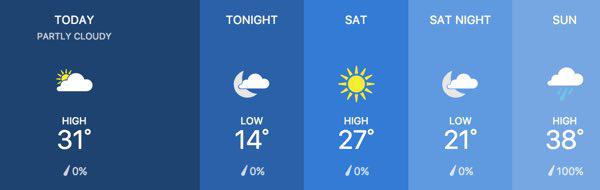
Stoddard County, Missouri - There's a slight chance we may get to the freezing mark this afternoon.
Tonight the low will dip down to 14 degrees with tomorrow's high at 27 degrees.
Saturday night the low will be around 21 degrees, but lookout Sunday!
Sunday's forecast is a high of around 38 degrees, but 100% chance of precipitation. What form of precipitation? RAIN!
The temperatures will dip just around the freezing mark at night so your Monday morning commute may see some slick spots of thin ice.
Monday's temps will be back above freezing into the upper 30s low 40s.
Weather provided by Bagby Wealth Management


Stoddard County, Missouri - The National Weather Service in Paducah, Kentucky has issued a Wind Chill Advisory for Stoddard County, Missouri.
... WIND CHILL ADVISORY REMAINS IN EFFECT UNTIL NOON CST TUESDAY
... A WIND CHILL ADVISORY REMAINS IN EFFECT UNTIL NOON CST TUESDAY.
* WHAT... LOWEST WIND CHILL READINGS TONIGHT WILL BE NEAR 10 BELOW ZERO. THE COLD WIND CHILLS WILL CAUSE FROSTBITE ON EXPOSED SKIN IN AS LITTLE AS 30 MINUTES.
* WHERE... ALL OF SOUTHERN ILLINOIS, SOUTHWEST INDIANA, WESTERN KENTUCKY, AND SOUTHEAST MISSOURI.
* WHEN... THROUGH NOON TUESDAY. PRECAUTIONARY/PREPAREDNESS ACTIONS
... A WIND CHILL ADVISORY MEANS THAT COLD AIR AND THE WIND WILL COMBINE TO CREATE LOW WIND CHILLS.
FROST BITE AND HYPOTHERMIA CAN OCCUR IF PRECAUTIONS ARE NOT TAKEN. MAKE SURE YOU WEAR A HAT AND GLOVES.
Stoddard County, Missouri - The National Weather Service in Paducah, Kentucky has issued a Special Weather Statement for Stoddard County, Missouri. Extreme cold temperatures this weekend through Tuesday.
... VERY COLD CONDITIONS ARE LIKELY FROM NEW YEAR'S EVE THROUGH TUESDAY
... BITTERLY COLD AIR WILL PUSH SOUTH INTO THE REGION THIS WEEKEND AND LAST THROUGH TUESDAY. VERY COLD TEMPERATURES COMBINED WITH STEADY NORTH TO NORTHWEST WINDS WILL RESULT IN DANGEROUSLY COLD WIND CHILL TEMPERATURES SATURDAY NIGHT THROUGH MONDAY NIGHT.
WIND CHILL TEMPERATURES FROM 0 TO 15 BELOW ZERO WILL BE COMMON, WITH THE COLDEST WIND CHILL TEMPERATURES EARLY NEW YEAR'S DAY MORNING.
WIND CHILL TEMPERATURES DURING THE DAY WILL GENERALLY BE IN THE SINGLE DIGITS TO JUST BELOW ZERO.
DUE TO THE EXTENDED COLD SNAP, PLAN TO REDUCE TIME SPENT OUTDOORS SUNDAY THROUGH TUESDAY, INCLUDING NEW YEAR'S DAY.
THESE CONDITIONS WILL INCREASE THE LIKELIHOOD OF HYPOTHERMIA AND FROST BITE.
ADVERSE IMPACTS TO INFRASTRUCTURE, SUCH AS PLUMBING, ARE LIKELY IF ADEQUATE STEPS ARE NOT TAKEN TO INSULATE EXPOSED PIPES.
CHECK ON THE ELDERLY, AND BE SURE TO MAKE ARRANGEMENTS FOR OUTDOOR PETS DURING THIS TIME OF VERY COLD WEATHER.
Weather provided by Bagby Wealth Management.
Southeast Missouri - Dry conditions throughout southeast Missouri have prompted several cities and counties to issue Burn Bans! If in doubt, don't burn until we see some significant rain!
Cape Girardeau County: Due to the combination of temperature, low humidity, dry ground covering, and the possibility of increasing winds, the Cape Girardeau County Commission issued a "no burn advisory" for Cape Girardeau County. All county residents are advised to postpone open outdoor burning until the fire danger decreases. If you are driving or working outdoors, be extremely careful to discard smoking materials. The grass along the highways is very dry and could easily ignite. Campers and hunters should be extremely careful.
Clarkton: The city of Clarkton, Missouri is under a no burn order until further notice. Anyone caught burning is subject to a fine plus court cost, according to Assistant Fire Chief Richard Blagg.
Holcomb: The Holcomb Fire Dept. has issued a burn ban until further notice. Anyone caught burning will be issued a citation according to Fire Chief Colleen Thompson. Contact authorities if you see anyone burning.
Madison County: A burn ban advisory was issued for Madison County, Missouri. Cherokee Pass Fire Chief Bill Starkey advises Madison County residents to not burn until further notice due to dry conditions and dry vegetation.
Puxico: A burn ban has been issued for the town of Puxico. Fire Chief Stacy Starnes advises residents not to burn until further notice.
Ripley County: The County Commission issued a no open burning order.
Scott City: A burn ban is in place until further notice.
Carter County Enacted 12/11/17 Until significant rainfall
Dent County Enacted 12/12/17 Expiring in 30 days
If your city has issued a burn ban, please let the ShowMe Times know by sending an email to news@showmetimes.com
When a county commission determines a burn ban is necessary, the county should also contact the Office of the State Fire Marshal by email at firesafe@dfs.dps.mo.gov for confirmation that the ban is appropriate. Please include a brief description of the danger(s) or hazard(s) threatening the county and be sure to include names, phone numbers, and email addresses in the event additional information is required.
For current drought conditions click HERE.

