ShowMe Weather
Flood Watch Issued for Stoddard County until Saturday Morning
September 27th 2024 by Dee Loflin

The National Weather Service in Paducah, Kentucky has issued a Flood Watch until 7 a.m. Saturday morning for Stoddard County.
Action Recommended
Avoid the subject event as per the instructions
Issued By
Paducah - KY, US, National Weather Service
Affected Area
Stoddard County
Description
...FLOOD WATCH REMAINS IN EFFECT THROUGH SATURDAY MORNING... WHAT...Flooding caused by excessive rainfall continues to be possible. WHERE...Portions of southern Illinois, including the following areas, Alexander, Gallatin, Hardin, Johnson, Massac, Pope, Pulaski, Saline, Union and Williamson, western Kentucky, including the following areas, Ballard, Caldwell, Calloway, Carlisle, Christian, Crittenden, Daviess, Fulton, Graves, Henderson, Hickman, Hopkins, Livingston, Lyon, Marshall, McCracken, McLean, Muhlenberg, Todd, Trigg, Union KY and Webster, and southeast Missouri, including the following areas, Mississippi, New Madrid, Scott and Stoddard. WHEN...Through Saturday morning. IMPACTS...Excessive runoff may result in flooding of rivers, creeks, streams, and other low-lying and flood-prone locations. ADDITIONAL DETAILS... - The remnants of Hurricane Helene are expected to bring widespread heavy rainfall to much of the area. A Flood Watch remains in effect for western Kentucky, portions of Southern Illinois, and portions of southeast Missouri where forecast rainfall ranges from 3 to 5 inches. Locally higher amounts are possible. - http://www.weather.gov/safety/flood PRECAUTIONARY/PREPAREDNESS ACTIONS... You should monitor later forecasts and be alert for possible Flood Warnings. Those living in areas prone to flooding should be prepared to take action should flooding develop.
Last Updated on September 27th 2024 by Dee Loflin
https://showmetimes.com/Blogpost/vk10/Flood-Watch-Issued-for-Stoddard-County-until-Saturday-Morning
Wind Advisory Issued for Stoddard County Until 1 a.m. Saturday
September 27th 2024 by Dee Loflin

The National Weather Service in Paducah Kentucky has issued a Wind Advisory from Friday at 7 p.m. until Saturday at 1 a.m.
Description
...WIND ADVISORY REMAINS IN EFFECT FROM 7 AM CDT /8 AM EDT/ FRIDAY TO 1 AM CDT /2 AM EDT/ SATURDAY... WHAT...Northeast winds of 20 to 30 mph with gusts of 40 to 50 mph are expected. Gusts to 55 mph are possible in the Evansville Tri-State region or along the I-64 corridor in Southern Illinois. WHERE...Portions of southern Illinois, southwest Indiana, western Kentucky, and southeast Missouri. WHEN...From 7 AM CDT /8 AM EDT/ Friday to 1 AM CDT /2 AM EDT/ Saturday. IMPACTS...Gusty winds will blow around unsecured objects. Tree limbs could be blown down and a few power outages may result. Heavy rainfall may result in waterlogged soils making trees more susceptible to wind damage. PRECAUTIONARY/PREPAREDNESS ACTIONS...
Last Updated on September 27th 2024 by Dee Loflin
https://showmetimes.com/Blogpost/vk0v/Wind-Advisory-Issued-for-Stoddard-County-Until-1-am-Saturday
Special Weather Statement for Stoddard County, MO - Tuesday, August 27, 2024
August 27th 2024 by Dee Loflin

The National Weather Service in Paducah, Kentucky has issued a SPECIAL WEATHER STATEMENT for Stoddard County, Missouri.
Action Recommended
Avoid the subject event as per the instructions
Issued By
Paducah - KY, US, National Weather Service
Affected Area
Stoddard County
Description
...Hot Temperatures Through Thursday... High temperatures will peak in the mid to upper 90s each afternoon through Thursday, with a few locations possibly touching 100. While humidity levels are expected to remain relatively low by late August standards, heat index readings will still peak in the upper 90s to low 100s each afternoon. A few readings near 105 are possible today and Wednesday, mainly focused near the Perryville, Missouri to Mount Vernon, Illinois corridor. Be sure to use caution if planning to be outdoors for long stretches. Drink plenty of water, take frequent breaks, and wear light colored and loose fitting clothing.
Last Updated on August 27th 2024 by Dee Loflin
https://showmetimes.com/Blogpost/vjth/Special-Weather-Statement-for-Stoddard-County-MO--Tuesday-August-27-2024
Excessive Heat Warning Issued for Stoddard County, Missouri
July 30th 2024 by Dee Loflin
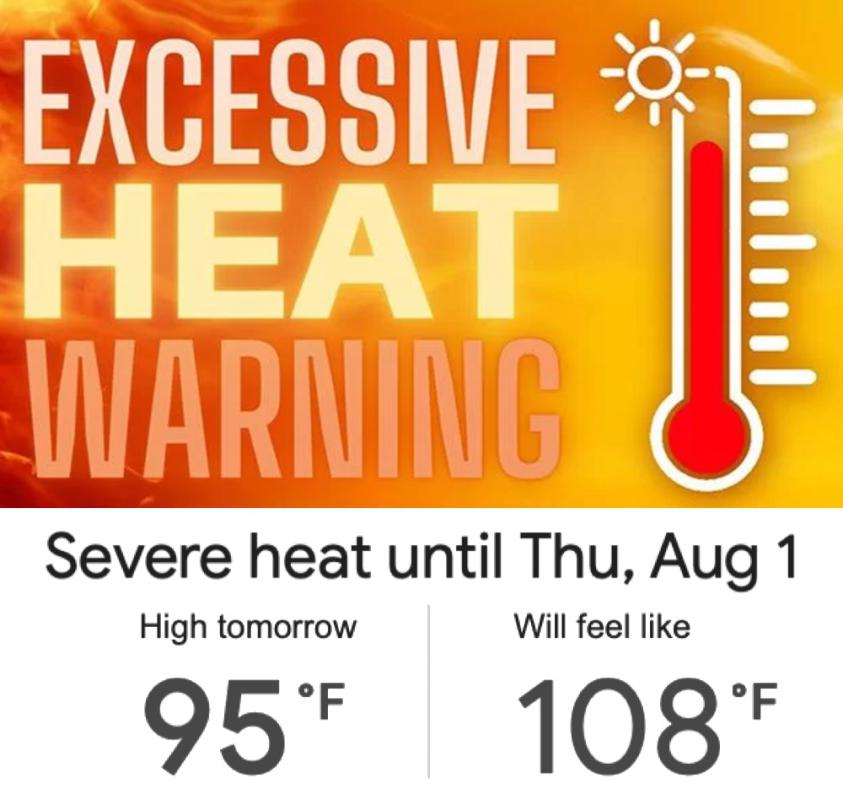
The National Weather Service in Paducah, Kentucky has issued an Excessive Heat Warning until 8 p.m. THURSDAY evening! Temperatures will reach 100 degrees!
Affected Area
Stoddard County
Description
...EXCESSIVE HEAT WARNING NOW IN EFFECT UNTIL 8 PM CDT THURSDAY... WHAT...Dangerously hot conditions with heat index values up to 113. WHERE...Portions of southern Illinois, western Kentucky, and southeast Missouri. WHEN...Until 8 PM CDT Thursday. IMPACTS...Heat related illnesses increase significantly during extreme heat and high humidity events. PRECAUTIONARY/PREPAREDNESS ACTIONS... Drink plenty of fluids, stay in an air-conditioned room, stay out of the sun, and check up on relatives and neighbors.
Last Updated on July 30th 2024 by Dee Loflin
https://showmetimes.com/Blogpost/vjr5/Excessive-Heat-Warning-Issued-for-Stoddard-County-Missouri
Heat Advisory Issued for Stoddard County by the National Weather Service
July 29th 2024 by Dee Loflin
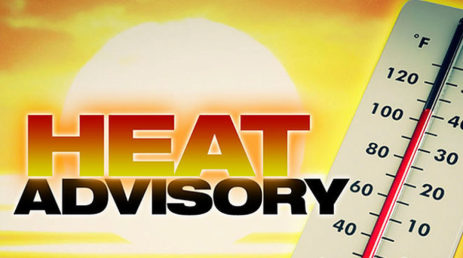
The National Weather Service in Paducah, Kentucky has issued a Heat Advisory for Stoddard County until 8 p.m. tonight.
Description
...HEAT ADVISORY NOW IN EFFECT FROM 11 AM THIS MORNING TO 8 PM CDT THIS EVENING... WHAT...Heat index values mainly around 105 degrees expected, but locally up to around 110 degrees is possible. WHERE...All of southeast Missouri. WHEN...From 11 AM this morning to 8 PM CDT this evening. IMPACTS...Hot temperatures and high humidity may cause heat illnesses. PRECAUTIONARY/PREPAREDNESS ACTIONS... Drink plenty of fluids, stay in an air-conditioned room, stay out of the sun, and check up on relatives and neighbors.
Last Updated on July 29th 2024 by Dee Loflin
https://showmetimes.com/Blogpost/vjr0/Heat-Advisory-Issued-for-Stoddard-County-by-the-National-Weather-Service
Heat Advisory in Effect until 8 p.m. Tuesday, July 16, 2024
July 14th 2024 by Dee Loflin

The National Weather Service in Paducah, Kentucky has extended the Heat Advisory until 8 p.m. Tuesday evening for Stoddard County.
Description
...HEAT ADVISORY NOW IN EFFECT UNTIL 8 PM CDT /9 PM EDT/ TUESDAY... WHAT...Heat index values of 105 to 110 degrees expected. WHERE...Portions of southern Illinois, southwest Indiana, western Kentucky, and southeast Missouri. WHEN...Until 8 PM CDT /9 PM EDT/ Tuesday. IMPACTS...Hot temperatures and high humidity may cause heat illnesses. PRECAUTIONARY/PREPAREDNESS ACTIONS... Drink plenty of fluids, stay in an air-conditioned room, stay out of the sun, and check up on relatives and neighbors. Take extra precautions when outside. Wear lightweight and loose fitting clothing. Try to limit strenuous activities to early morning or evening. Take action when you see symptoms of heat exhaustion and heat stroke. To reduce risk during outdoor work, the Occupational Safety and Health Administration recommends scheduling frequent rest breaks in shaded or air conditioned environments. Anyone overcome by heat should be moved to a cool and shaded location. Heat stroke is an emergency! Call 9 1 1.
Last Updated on July 14th 2024 by Dee Loflin
https://showmetimes.com/Blogpost/vjpi/Heat-Advisory-in-Effect-until-8-pm-Tuesday-July-16-2024
Flood Watch Issued for Stoddard County, Missouri Thru Wednesday Morning
July 08th 2024 by Dee Loflin

The National Weather Service in Paducah, KY has issued a Flood Watch for Stoddard County, Missouri from Monday thru Wednesday morning.
Affected Area
Stoddard County
Description
...FLASH FLOOD WATCH IN EFFECT FROM LATE TONIGHT THROUGH WEDNESDAY MORNING... WHAT...Flash flooding caused by excessive rainfall is possible. WHERE...Portions of southern Illinois, including the following areas, Alexander, Edwards, Franklin, Gallatin, Hamilton, Hardin, Jackson, Jefferson, Johnson, Massac, Perry IL, Pope, Pulaski, Saline, Union, Wabash, Wayne IL, White and Williamson, southwest Indiana, including the following areas, Gibson, Posey and Vanderburgh, western Kentucky, including the following areas, Ballard, Carlisle, Crittenden, Fulton, Graves, Henderson, Hickman, Livingston, Marshall, McCracken and Union KY, and southeast Missouri, including the following areas, Bollinger, Butler, Cape Girardeau, Carter, Mississippi, New Madrid, Perry MO, Ripley, Scott, Stoddard and Wayne MO. WHEN...From late tonight through Wednesday morning. IMPACTS...Excessive runoff may result in flooding of rivers, creeks, streams, and other low-lying and flood-prone locations. ADDITIONAL DETAILS... - The remnants of Hurricane Beryl are forecast to move through the region late tonight into Wednesday morning. Steady rain with heavier showers and thunderstorms are expected. Parts of southeast Missouri and southern Illinois may receive 2 to 4 inches of rain and locally higher amounts are possible. Parts of western Kentucky and southwest Indiana may see heavy rain in showers and storms but the total rainfall amounts are less certain. - http://www.weather.gov/safety/flood PRECAUTIONARY/PREPAREDNESS ACTIONS... You should monitor later forecasts and be prepared to take action should Flash Flood Warnings be issued.
More Information
.The remnants of Hurricane Beryl are expected to move across the region Monday night through early Wednesday. Persistent and sometimes heavy rainfall is expected with parts of southeast Missouri and southwest Illinois likely to receive 2 to 4 inches of rain with locally higher amounts possible. Thunderstorms on Tuesday may also produce flash flooding across southwest Indiana and western Kentucky.
Last Updated on July 08th 2024 by Dee Loflin
https://showmetimes.com/Blogpost/vjp0/Flood-Watch-Issued-for-Stoddard-County-Missouri-Thru-Wednesday-Morning

