Stoddard County, Missouri - The National Weather Service in Paducah, Kentucky has issued a Special Weather Statement for our area.
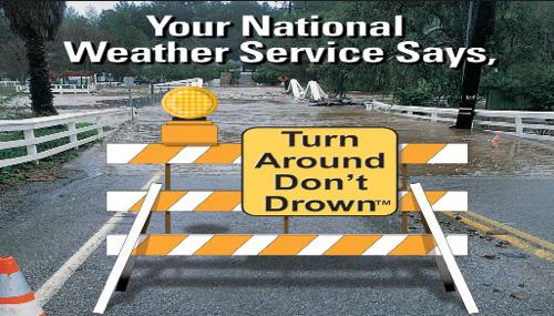
... TURN AROUND DONT DROWN...
ALTHOUGH THE HEAVY RAIN HAS LEFT THE QUAD STATE REGION... THE DANGERS OF FLOODING STILL REMAIN IN AND NEAR MAJOR RIVER SYSTEMS IN OUR AREA. DONT BECOME A FLOOD STATISTIC... KEEP YOU AND YOUR FAMILY FROM HARMS WAY NEAR FLOOD WATERS.
THE RECENT HEAVY RAIN... SNOW AND ICE THAT FELL ACROSS THE MIDWEST THE LAST SEVERAL DAYS IS DRAINING FROM CREEKS AND STREAMS INTO MAJOR RIVERS ACROSS OUR AREA. AS THESE LARGER RIVERS CONTINUE TO RISE... SOME TO NEAR RECORD LEVELS... THE WATER WILL BACK UP INTO SMALL RIVERS THAT FEED INTO THEM.
IF YOUR TRAVELS TAKE YOU ACROSS BRIDGES OR ROADS THAT ARE PRONE TO RIVER FLOODING... PLEASE KEEP POSTED ON ANY ROAD CLOSURES ALONG YOUR ROUTE. MAKE PLANS TO USE ALTERNATE ROUTES TO REACH YOUR DESTINATION UNTIL THE FLOOD THREAT HAS LEFT THE AREA.
PLEASE CONTACT YOUR LOCAL HIGHWAY OR ROAD DEPARTMENT TO SEE WHERE ROADS ARE CLOSED IN YOUR AREA.
DO NOT DRIVE AROUND ANY POSTED BARRICADES... YOU ARE PUTTING YOURSELF... YOUR FAMILY... AND EMERGENCY WORKERS WHO MAY HAVE TO RESCUE YOU IN GRAVE DANGER. THE BARRICADES ARE THERE FOR YOUR SAFETY... DONT IGNORE THEM.
THE BEST ADVICE IS TO TURN AROUND... DONT DROWN. WHETHER THE WATER OVER THE ROAD IS OR IS NOT MOVING... THE ROAD MAY BE WASHED OUT AND COULD ALLOW YOUR CAR TO SINK IN THE WATER.
THESE FLOOD WATERS WILL EVENTUALLY RECEDE IN EARLY JANUARY. IN THE MEANTIME... AVOID FLOODED ROADS AT ALL COSTS... YOUR LIFE MAY DEPEND ON IT.
Stoddard County, Missouri - The National Weather Service issued a Flood Warning for the St. Francis River at Fisk.
THE NATIONAL WEATHER SERVICE IN PADUCAH, KENTUCKY HAS ISSUED
* FLOOD WARNING FOR THE ST. FRANCIS RIVER AT FISK. * FROM LATE FRIDAY NIGHT UNTIL FURTHER NOTICE. * AT 6 AM WEDNESDAY THE STAGE WAS 18.5 FEET. * FLOOD STAGE IS 20.0 FEET. * MINOR FLOODING IS FORECAST. * FORECAST... RISE ABOVE FLOOD STAGE SATURDAY MORNING AND CREST NEAR 21.1 FEET FRIDAY, JANUARY 8TH. * IMPACT... AT 20.0 FEET... CONSIDERABLE FLOODING OCCURS
... THE NATIONAL WEATHER SERVICE IN PADUCAH, KENTUCKY HAS ISSUED A FLOOD WARNING FOR THE ST. FRANCIS RIVER IN SOUTHEAST MISSOURI...
AT FISK AFFECTING BUTLER AND STODDARD COUNTIES
.DUE TO THE HEAVY RAINS ACROSS SOUTHEAST MISSOURI DURING THE PAST WEEK, THE WAPPAPELLO DAM WILL BE RELEASING A LARGE ABOUT OF WATER OVER THE NEXT COUPLE OF DAYS. MINOR FLOODING WILL DEVELOP ALONG THE ST. FRANCIS RIVER AT FISK EARLY THIS WEEKEND.
PRECAUTIONARY/PREPAREDNESS ACTIONS...
SAFETY MESSAGE...
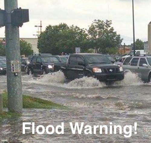
NEVER DRIVE CARS... TRUCKS OR SPORT UTILITY VEHICLES THROUGH FLOODED AREAS. THE WATER MAY BE TOO DEEP TO ALLOW SAFE PASSAGE. NEVER ALLOW CHILDREN TO PLAY IN OR NEAR FLOOD WATERS.

|
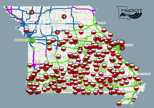
The Missouri Department of Transportation has closed routes in Southeast Missouri due to the recent flooding. Motorists are urged to use extreme caution and plan alternate routes. Routes that are closed include: Bollinger County
Butler County
Cape Girardeau County
Carter County
Douglas County
Dunklin County
Howell County
Iron County
Madison County
Mississippi County
New Madrid
Oregon County
Ozark County
Perry County
Reynolds County
Ripley County
Scott County
Shannon County
Ste. Genevieve County
St. Francois County
Stoddard County
Texas County
Wayne County
Wright County
|
|
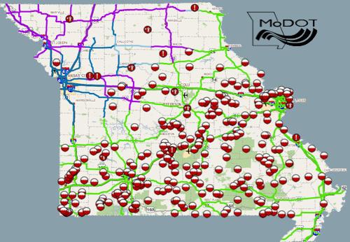
The Missouri Department of Transportation has closed routes in Southeast Missouri due to the recent flooding. Motorists are urged to use extreme caution and plan alternate routes. Routes that are closed include: Bollinger County
Butler County
Cape Girardeau County
Carter County
Douglas County
Dunklin County
Howell County
Iron County
Madison County
New Madrid
Oregon County
Ozark County
Perry County
Reynolds County
Ripley County
Scott County
Shannon County
Ste. Genevieve County
St. Francois County
Stoddard County
Texas County
Wayne County
Wright County
For more information, please contact MoDOT's Customer Service Center toll-free at 1-888-ASK-MODOT (1-888-275-6636) or visit the Traveler Information Map at: http://maps.modot.mo.gov/timi/index.aspx?district=10 |

Stoddard County, Missouri - The National Weather Service in Paducah, Kentucky has issued a Wind Advisory for Stoddard County, Missouri.
.. WIND ADVISORY IN EFFECT UNTIL 6 PM CST THIS EVENING...
THE NATIONAL WEATHER SERVICE IN PADUCAH HAS ISSUED A WIND ADVISORY... WHICH IS IN EFFECT UNTIL 6 PM CST THIS EVENING.
* TIMING... STRONG WINDS WILL BEGIN BETWEEN OVER SOUTHEAST MISSOURI BETWEEN NOON AND 100 PM... THEN SPREAD INTO WEST KENTUCKY AND SOUTHERN ILLINOIS BY 200 PM.
* WINDS... WIND GUSTS TO 45 MPH ARE POSSIBLE
* IMPACTS... RECENT AND ON-GOING HEAVY RAINS HAVE SATURATED THE GROUND. ANY STRONG WINDS HAVE THE POTENTIAL TO UPROOT TREES. POWER OUTAGES ARE POSSIBLE IF THE TREES FALL ON POWER LINES.
PRECAUTIONARY/PREPAREDNESS ACTIONS...
A WIND ADVISORY IS ISSUED WHEN SUSTAINED WINDS ARE EXPECTED TO REACH 30 MPH OR GREATER FOR LONGER THAN ONE HOUR... OR WIND GUSTS ARE EXPECTED TO REACH 45 MPH FOR ANY DURATION.
&&
|
Missouri - The Missouri Department of Transportation has closed routes in Southeast Missouri due to the recent flooding. Motorists are urged to use extreme caution and plan alternate routes. Routes that are closed include: Bollinger County
Butler County
Cape Girardeau County
Carter County
Douglas County
Dunklin County
Howell County
Iron County
Madison County
New Madrid
Oregon County
Ozark County
Perry County
Reynolds County
Ripley County
Scott County
Shannon County
Texas County
Wayne County
Wright County
For more information, please contact MoDOT's Customer Service Center toll-free at 1-888-ASK-MODOT (1-888-275-6636) or visit the Traveler Information Map at: http://maps.modot.mo.gov/timi/index.aspx?district=10 |

Stoddard County, Missouri - The National Weather Service in Paducah, Kentucky has issued a Flash Flood Watch from Saturday, noon through Monday afternoon for Stoddard County, Missouri.
... FLASH FLOOD WATCH REMAINS IN EFFECT FROM SATURDAY AFTERNOON THROUGH MONDAY AFTERNOON...
THE FLASH FLOOD WATCH CONTINUES FOR
* PORTIONS OF SOUTHERN ILLINOIS AND SOUTHEAST MISSOURI... INCLUDING THE FOLLOWING AREAS... IN SOUTHERN ILLINOIS... EDWARDS... FRANKLIN... HAMILTON... JACKSON... JEFFERSON... PERRY IL... WABASH AND WAYNE IL. IN SOUTHEAST MISSOURI... BOLLINGER... BUTLER... CAPE GIRARDEAU... CARTER... NEW MADRID... PERRY MO... RIPLEY... SCOTT... STODDARD AND WAYNE MO.
* FROM SATURDAY AFTERNOON THROUGH MONDAY AFTERNOON
* RAIN WILL DEVELOP AGAIN BY SATURDAY... AND CONTINUE OFF AND ON THROUGH THE REMAINDER OF THE CHRISTMAS HOLIDAY WEEKEND AND ON INTO MONDAY. RAIN WILL BE HEAVY AT TIMES. FORECAST STORM TOTAL RAINFALL COULD EXCEED 4 INCHES BY THE TIME THE SYSTEM IS DEPARTING MONDAY EVENING. ISOLATED THUNDERSTORMS COULD CAUSE LOCALIZED HIGHER RAINFALL TOTALS... ESPECIALLY SUNDAY NIGHT AND MONDAY.
* THE GROUND IS WET AND WILL SATURATE QUICKLY WITH ADDITIONAL RAINS. MANY STREAMS AND CREEKS ARE ALREADY AT OR NEAR BANKFULL. ADDITIONAL ACCUMULATED INCHES OF RAINFALL WILL CAUSE SMALL RIVERS AND STREAMS TO REACT QUICKLY. LOW LYING AND FLOOD PRONE AREAS WILL BE PARTICULARLY PRONE TO FLOODING.
PRECAUTIONARY/PREPAREDNESS ACTIONS...
A FLASH FLOOD WATCH MEANS THAT CONDITIONS MAY DEVELOP THAT LEAD TO FLASH FLOODING. FLASH FLOODING IS A VERY DANGEROUS SITUATION.
YOU SHOULD MONITOR LATER FORECASTS AND BE PREPARED TO TAKE ACTION SHOULD FLASH FLOOD WARNINGS BE ISSUED.

