
|
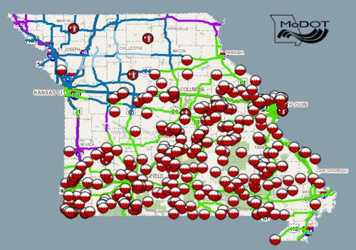
The Missouri Department of Transportation has closed routes in Southeast Missouri due to the recent flooding. Motorists are urged to use extreme caution and plan alternate routes. Routes that are closed include: Bollinger County
Butler County
Cape Girardeau County
Carter County
Douglas County
Dunklin County
Howell County
Iron County
Madison County
Mississippi County
New Madrid
Oregon County
Ozark County
Perry County
Reynolds County
Ripley County
Scott County
Shannon County
Ste. Genevieve County
St. Francois County
Stoddard County
Texas County
Wayne County
Wright County
|
|
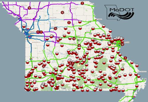
The Missouri Department of Transportation has closed routes in Southeast Missouri due to the recent flooding. Motorists are urged to use extreme caution and plan alternate routes. Routes that are closed include: Bollinger County
Butler County
Cape Girardeau County
Carter County
Douglas County
Dunklin County
Howell County
Iron County
Madison County
New Madrid
Oregon County
Ozark County
Perry County
Reynolds County
Ripley County
Scott County
Shannon County
Ste. Genevieve County
St. Francois County
Stoddard County
Texas County
Wayne County
Wright County
For more information, please contact MoDOT's Customer Service Center toll-free at 1-888-ASK-MODOT (1-888-275-6636) or visit the Traveler Information Map at: http://maps.modot.mo.gov/timi/index.aspx?district=10 |

Stoddard County, Missouri - The National Weather Service in Paducah, Kentucky has issued a Wind Advisory for Stoddard County, Missouri.
.. WIND ADVISORY IN EFFECT UNTIL 6 PM CST THIS EVENING...
THE NATIONAL WEATHER SERVICE IN PADUCAH HAS ISSUED A WIND ADVISORY... WHICH IS IN EFFECT UNTIL 6 PM CST THIS EVENING.
* TIMING... STRONG WINDS WILL BEGIN BETWEEN OVER SOUTHEAST MISSOURI BETWEEN NOON AND 100 PM... THEN SPREAD INTO WEST KENTUCKY AND SOUTHERN ILLINOIS BY 200 PM.
* WINDS... WIND GUSTS TO 45 MPH ARE POSSIBLE
* IMPACTS... RECENT AND ON-GOING HEAVY RAINS HAVE SATURATED THE GROUND. ANY STRONG WINDS HAVE THE POTENTIAL TO UPROOT TREES. POWER OUTAGES ARE POSSIBLE IF THE TREES FALL ON POWER LINES.
PRECAUTIONARY/PREPAREDNESS ACTIONS...
A WIND ADVISORY IS ISSUED WHEN SUSTAINED WINDS ARE EXPECTED TO REACH 30 MPH OR GREATER FOR LONGER THAN ONE HOUR... OR WIND GUSTS ARE EXPECTED TO REACH 45 MPH FOR ANY DURATION.
&&
|
Missouri - The Missouri Department of Transportation has closed routes in Southeast Missouri due to the recent flooding. Motorists are urged to use extreme caution and plan alternate routes. Routes that are closed include: Bollinger County
Butler County
Cape Girardeau County
Carter County
Douglas County
Dunklin County
Howell County
Iron County
Madison County
New Madrid
Oregon County
Ozark County
Perry County
Reynolds County
Ripley County
Scott County
Shannon County
Texas County
Wayne County
Wright County
For more information, please contact MoDOT's Customer Service Center toll-free at 1-888-ASK-MODOT (1-888-275-6636) or visit the Traveler Information Map at: http://maps.modot.mo.gov/timi/index.aspx?district=10 |

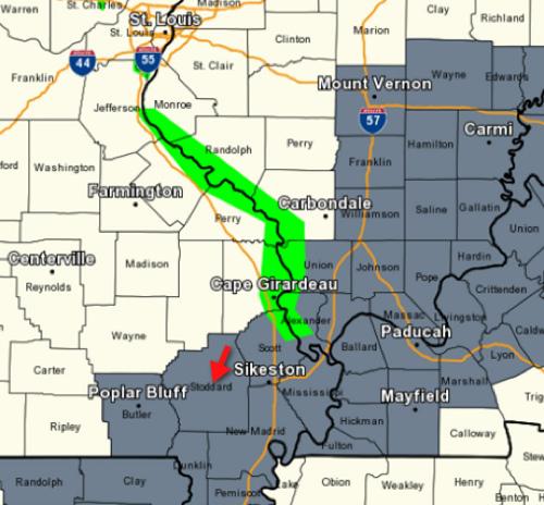
Stoddard County, Missouri - The National Weather Service in Paducah, Kentucky has issued a Flash Flood Watch from Saturday, noon through Monday afternoon for Stoddard County, Missouri.
... FLASH FLOOD WATCH REMAINS IN EFFECT FROM SATURDAY AFTERNOON THROUGH MONDAY AFTERNOON...
THE FLASH FLOOD WATCH CONTINUES FOR
* PORTIONS OF SOUTHERN ILLINOIS AND SOUTHEAST MISSOURI... INCLUDING THE FOLLOWING AREAS... IN SOUTHERN ILLINOIS... EDWARDS... FRANKLIN... HAMILTON... JACKSON... JEFFERSON... PERRY IL... WABASH AND WAYNE IL. IN SOUTHEAST MISSOURI... BOLLINGER... BUTLER... CAPE GIRARDEAU... CARTER... NEW MADRID... PERRY MO... RIPLEY... SCOTT... STODDARD AND WAYNE MO.
* FROM SATURDAY AFTERNOON THROUGH MONDAY AFTERNOON
* RAIN WILL DEVELOP AGAIN BY SATURDAY... AND CONTINUE OFF AND ON THROUGH THE REMAINDER OF THE CHRISTMAS HOLIDAY WEEKEND AND ON INTO MONDAY. RAIN WILL BE HEAVY AT TIMES. FORECAST STORM TOTAL RAINFALL COULD EXCEED 4 INCHES BY THE TIME THE SYSTEM IS DEPARTING MONDAY EVENING. ISOLATED THUNDERSTORMS COULD CAUSE LOCALIZED HIGHER RAINFALL TOTALS... ESPECIALLY SUNDAY NIGHT AND MONDAY.
* THE GROUND IS WET AND WILL SATURATE QUICKLY WITH ADDITIONAL RAINS. MANY STREAMS AND CREEKS ARE ALREADY AT OR NEAR BANKFULL. ADDITIONAL ACCUMULATED INCHES OF RAINFALL WILL CAUSE SMALL RIVERS AND STREAMS TO REACT QUICKLY. LOW LYING AND FLOOD PRONE AREAS WILL BE PARTICULARLY PRONE TO FLOODING.
PRECAUTIONARY/PREPAREDNESS ACTIONS...
A FLASH FLOOD WATCH MEANS THAT CONDITIONS MAY DEVELOP THAT LEAD TO FLASH FLOODING. FLASH FLOODING IS A VERY DANGEROUS SITUATION.
YOU SHOULD MONITOR LATER FORECASTS AND BE PREPARED TO TAKE ACTION SHOULD FLASH FLOOD WARNINGS BE ISSUED.

Stoddard County, Missouri - The National Weather Service has issued a Tornado Watch for Stoddard County, Missouri.
THE NATIONAL WEATHER SERVICE HAS ISSUED TORNADO WATCH 558 IN EFFECT UNTIL 5 PM CST THIS AFTERNOON FOR THE FOLLOWING AREAS
IN ILLINOIS THIS WATCH INCLUDES 19 COUNTIES
IN SOUTHERN ILLINOIS
ALEXANDER EDWARDS FRANKLIN GALLATIN HAMILTON HARDIN JACKSON JEFFERSON JOHNSON MASSAC PERRY POPE PULASKI SALINE UNION WABASH WAYNE WHITE WILLIAMSON
IN INDIANA THIS WATCH INCLUDES 3 COUNTIES
IN SOUTHWEST INDIANA
GIBSON POSEY VANDERBURGH
IN KENTUCKY THIS WATCH INCLUDES 14 COUNTIES
IN WESTERN KENTUCKY
BALLARD CALDWELL CALLOWAY CARLISLE CRITTENDEN FULTON GRAVES HENDERSON HICKMAN LIVINGSTON LYON MARSHALL MCCRACKEN UNION
IN MISSOURI THIS WATCH INCLUDES 11 COUNTIES
IN SOUTHEAST MISSOURI
BOLLINGER BUTLER CAPE GIRARDEAU CARTER MISSISSIPPI NEW MADRID PERRY RIPLEY SCOTT STODDARD WAYNE
THIS INCLUDES THE CITIES OF... ALBION... BARDWELL... BENTON... BLOOMFIELD... CAIRO... CAPE GIRARDEAU... CARBONDALE... CARMI... CHARLESTON... CLINTON... DONIPHAN... EDDYVILLE... ELIZABETHTOWN... EVANSVILLE... FAIRFIELD... FORT BRANCH... GOLCONDA... HARRISBURG... HENDERSON... HERRIN... HICKMAN... JONESBORO... MARBLE HILL... MARION... MAYFIELD... MCLEANSBORO... METROPOLIS... MORGANFIELD... MOUND CITY... MOUNT CARMEL... MOUNT VERNON... MURRAY... NEW MADRID... PADUCAH... PERRYVILLE... PIEDMONT... PINCKNEYVILLE... POPLAR BLUFF... POSEYVILLE... PRINCETON... SHAWNEETOWN... SIKESTON... SMITHLAND... VAN BUREN... VIENNA... WEST FRANKFORT AND WICKLIFFE.
Stoddard County, Missouri - The National Weather Service has issued a Dense Fog Advisory for Stoddard County, Missouri and most of the Heartland.
... DENSE FOG ADVISORY IN EFFECT UNTIL MIDNIGHT CST TONIGHT...
THE NATIONAL WEATHER SERVICE IN PADUCAH HAS ISSUED A DENSE FOG ADVISORY... WHICH IS IN EFFECT UNTIL MIDNIGHT CST TONIGHT.
VISIBILITY... VISIBILITIES FROM ONE QUARTER MILE TO NEAR ZERO CAN BE EXPECTED. AREAS AFFECTED ARE GENERALLY EAST OF A LINE FROM MOUNT VERNON ILLINOIS TO CAPE GIRARDEAU TO POPLAR BLUFF MISSOURI... AND NORTH AND WEST OF A LINE FROM CALHOUN TO MAYFIELD KENTUCKY.
* IMPACTS... MOTORISTS ACROSS THIS REGION SHOULD ALLOW EXTRA TIME TO REACH THEIR DESTINATIONS THIS EVENING AND BE PREPARED FOR SUDDEN DEVELOPMENT OF VERY THICK FOG AND DRIZZLE.
PRECAUTIONARY/PREPAREDNESS ACTIONS...
A DENSE FOG ADVISORY MEANS VISIBILITIES WILL FREQUENTLY BE REDUCED TO LESS THAN ONE QUARTER MILE. IF DRIVING... SLOW DOWN... USE YOUR LOW BEAM HEADLIGHTS... AND LEAVE PLENTY OF DISTANCE AHEAD OF YOU.

