
The National Weather Service in Paducah has issued a Severe Thunderstorm Warning for... West central New Madrid County in southeastern Missouri... Western Stoddard County in southeastern Missouri... Eastern Butler County in southeastern Missouri...
Until 1130 PM CDT.
At 1052 PM CDT, severe thunderstorms were located along a line extending from near Hendrickson to near Harviell to near Glennonville to Holcomb, moving north at 45 mph.
HAZARD...60 mph wind gusts and penny size hail.
SOURCE...Radar indicated.
IMPACT...Expect damage to roofs, siding, and trees.
Severe thunderstorms will be near... Poplar Bluff around 1100 PM CDT. Fisk and Dudley around 1110 PM CDT.
Other locations in the path of these severe thunderstorms include Puxico and Dexter.
PRECAUTIONARY/PREPAREDNESS ACTIONS...
For your protection move to an interior room on the lowest floor of a building.
To report severe weather, contact your nearest law enforcement agency. They will send your report to the National Weather Service office in Paducah.
HAIL THREAT...RADAR INDICATED; MAX HAIL SIZE...0.75 IN; WIND THREAT...RADAR INDICATED; MAX WIND GUST...60 MPH

Stoddard County, MO - Weather provided by Bagby Wealth Management - The National Weather Service in Paducah, KY has issued a Lake Wind Advisory in effect until 6 p.m. today.
Affected Area
Southwest Indiana, southeast Missouri, western Kentucky and southern Illinois
Description
...LAKE WIND ADVISORY IN EFFECT UNTIL 6 PM CDT THIS EVENING...
WHAT...South winds 15 to 20 mph with gusts up to 30 mph expected.
WHERE...Southwest Indiana, southeast Missouri, western Kentucky and southern Illinois.
WHEN...Until 6 PM CDT this evening.
IMPACTS...Strong winds and rough waves on area lakes will create hazardous conditions for small craft.
PRECAUTIONARY/PREPAREDNESS ACTIONS...
Boaters on area lakes should use extra caution since strong winds and rough waves can overturn small craft.

The National Weather Service in Paducah, Kentucky has issued a Frost Advisory from 3 a.m. to 8 a.m. Wednesday, April 27th.
Affected Area
Portions of southeast Missouri, much of southern Illinois, northwest Kentucky, and the Kentucky Pennyrile
Description
...FROST ADVISORY IN EFFECT FROM 3 AM TO 8 AM CDT WEDNESDAY...
WHAT...Temperatures as low as 35 degrees will result in frost formation.
WHERE...Portions of southeast Missouri, much of southern Illinois, northwest Kentucky, and the Kentucky Pennyrile.
WHEN...From 3 AM to 8 AM CDT Wednesday.
IMPACTS...Frost could damage sensitive outdoor vegetation if left uncovered.
PRECAUTIONARY/PREPAREDNESS ACTIONS...
Take steps now to protect tender plants from the cold.

Stoddard County, MO - The National Weather Service in Paducah, KY has issued a FROST ADVISORY for 2 a.m. - 8 a.m. Tuesday morning.
In southeast Missouri, along and south of a Doniphan to Cape Girardeau line, in southern Illinois along and south of the Shawnee Hills, and in west Kentucky, the Purchase area and Livingston county
Description
...FROST ADVISORY IN EFFECT FROM 2 AM TO 8 AM CDT TUESDAY...
WHAT...Temperatures as low as 33 will result in frost formation.
WHERE...In southeast Missouri, along and south of a Doniphan to Cape Girardeau line, in southern Illinois along and south of the Shawnee Hills, and in west Kentucky, the Purchase area and Livingston county.
WHEN...From 2 AM to 8 AM CDT Tuesday.
IMPACTS...Frost could kill sensitive outdoor vegetation if left uncovered.
PRECAUTIONARY/PREPAREDNESS ACTIONS...
Take steps now to protect tender plants from the cold.

Stoddard County, MO - The National Weather Service in Paducah, Kentucky has issued a Special Weather Statement with regards to frost late tonight.
...SPECIAL WEATHER STATEMENT...
Isolated areas across southwest Indiana, west Kentucky, the southern tip of southern Illinois, and the southern half of southeast Missouri may experience a brief freeze or patchy frost late tonight, mainly in sheltered areas. Drier air moving in tonight along with a persistent northwest breeze should prevent widespread frost formation.

Stoddard County, MO - The National Weather Service in Paducah,Kentucky has issued a Tornado Watch for Stoddard County.
Affected Area
Stoddard County
Description
MO . MISSOURI COUNTIES INCLUDED ARE
BOLLINGER BUTLER CAPE GIRARDEAU CARTER CRAWFORD DENT DOUGLAS HOWELL IRON JEFFERSON MADISON MISSISSIPPI NEW MADRID OREGON OZARK PERRY REYNOLDS RIPLEY SCOTT SHANNON ST. FRANCOIS STE. GENEVIEVE STODDARD TEXAS WASHINGTON WAYNE
More Information
TORNADO WATCH 121 IS IN EFFECT UNTIL 400 PM CDT FOR THE FOLLOWING LOCATIONS
The National Weather Service in Paducah, KY has issued a Hazardous Weather Outlook for southeast Missouri for early Wednesday through the evening hours.
This Hazardous Weather Outlook is for portions of southern Illinois, southwest Indiana, western Kentucky, and southeast Missouri.
DAY ONE...Tonight
Scattered thunderstorms will be possible late tonight. Locally heavy rainfall and lightning are expected to be the primary hazards, though some small hail cannot be ruled out.
DAYS TWO THROUGH SEVEN...Wednesday through Monday
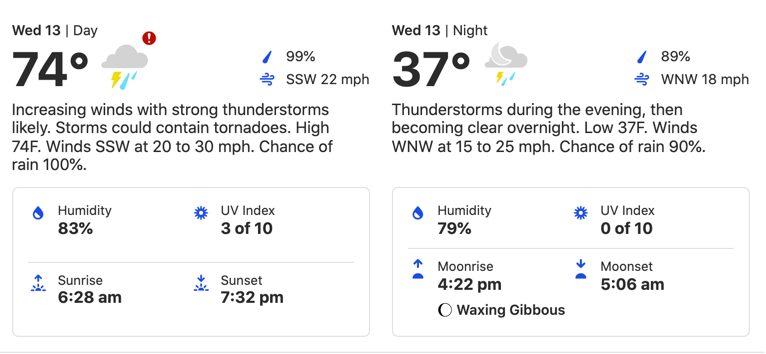
Severe thunderstorms are expected to develop over southeast Missouri early Wednesday afternoon, then progress eastward through the rest of the region later Wednesday afternoon and evening along and ahead of a cold front. Damaging winds, large hail, and even some tornadoes will all be possible with this system.
In addition, torrential rainfall with these thunderstorms may produce flash flooding, especially in southern portions of western Kentucky where 2 to 5 inches of rain fell last night.
SPOTTER INFORMATION STATEMENT...
Skywarn spotter activation will likely be needed, especially Wednesday afternoon and Wednesday evening.

