
Stoddard County, MO - The National Weather Service in Paducah, Kentucky has issued a Lake Wind Advisory for Stoddard County until 5 p.m. today, Monday, September 27, 2021.
Affected Area
Portions of southeast Missouri, southern Illinois, southwest Indiana, and western Kentucky
Description
...LAKE WIND ADVISORY IN EFFECT FROM 10 AM THIS MORNING TO 5 PM CDT THIS AFTERNOON...
WHAT...Southwest winds 15 to 20 mph with gusts of 20 to 25 mph on area lakes.
WHERE...Portions of southeast Missouri, southern Illinois, southwest Indiana, and western Kentucky.
WHEN...From 10 AM this morning to 5 PM CDT this afternoon.
IMPACTS...Strong winds and rough chop on area lakes will create hazardous conditions for small craft.
ADDITIONAL DETAILS...Some lakes impacted include Rend Lake, Crab Orchard Lake, Kinkaid Lake, Cedar Lake, Devil's Kitchen Lake, Little Grassy Lake, Lake of Egypt, Lake Wappapello, Clearwater Lake, Lake Barkley, and Kentucky Lake.
PRECAUTIONARY/PREPAREDNESS ACTIONS...
Boaters on area lakes should use extra caution since strong winds and rough waves can overturn small craft.

Stoddard County, MO - The National Weather Service in Paducah, KY has issued a Lake Wind Advisory for Stoddard County.
Affected Area
Portions of southwest Indiana, southeast Missouri, western Kentucky and southern Illinois
Description
...LAKE WIND ADVISORY IN EFFECT FROM 10 AM THIS MORNING TO 5 PM CDT THIS AFTERNOON...
WHAT...North winds 10 to 20 mph with gusts up to 30 mph expected.
WHERE...Portions of southwest Indiana, southeast Missouri, western Kentucky and southern Illinois.
WHEN...From 10 AM this morning to 5 PM CDT this afternoon.
IMPACTS...Strong winds and rough waves on area lakes will create hazardous conditions for small craft.
PRECAUTIONARY/PREPAREDNESS ACTIONS...
Boaters on area lakes should use extra caution since strong winds and rough waves can overturn small craft.

Stoddard County, MO - The National Weather Service in Paducah, KY has issued a HEAT ADVISORY until 7 p.m. Thursday evening for Stoddard County.
...HEAT ADVISORY REMAINS IN EFFECT UNTIL 7 PM CDT THIS EVENING...
WHAT...Heat index values from 102 to 107 degrees are expected again this afternoon.
WHERE...Southwest Indiana, western Kentucky, southern Illinois, and southeast Missouri.
WHEN...Through 7 PM CDT Thursday.
IMPACTS...Hot temperatures and high humidity may cause heat illnesses to occur. The cumulative effect of several days of high heat indices can be greater than a single day of excessive heat.
ADDITIONAL DETAILS...Outdoor events especially vulnerable to heat include after-school athletic games and practices.
PRECAUTIONARY/PREPAREDNESS ACTIONS...
Drink plenty of fluids, stay in an air-conditioned room, stay out of the sun, and check up on relatives and neighbors. To reduce risk during outdoor work, take frequent rest breaks in shaded or air conditioned environments. Make sure outdoor pets have plenty of fresh water. Bring them indoors out of the heat if possible, especially during the heat of the day.

Stoddard County, MO - The National Weather Service in Paducah, KY has issued a Heat Advisory until 7 p.m. Thursday, August 26th.
...HEAT ADVISORY REMAINS IN EFFECT FROM NOON TODAY TO 7 PM CDT THURSDAY...
WHAT...Daily heat index values of 100 to 108 are expected.
WHERE...Southeast Missouri, far west Kentucky and southwest Illinois.
WHEN...From noon today to 7 PM CDT Thursday.
IMPACTS...Hot temperatures and high humidity may cause heat illnesses to occur.
PRECAUTIONARY/PREPAREDNESS ACTIONS...
Drink plenty of fluids, stay in an air-conditioned room, stay out of the sun, and check up on relatives and neighbors. Young children and pets should never be left unattended in vehicles under any circumstances.
Take extra precautions if you work or spend time outside. When possible reschedule strenuous activities to early morning or evening. Know the signs and symptoms of heat exhaustion and heat stroke. Wear lightweight and loose fitting clothing when possible. To reduce risk during outdoor work, the Occupational Safety and Health Administration recommends scheduling frequent rest breaks in shaded or air conditioned environments. Anyone overcome by heat should be moved to a cool and shaded location. Heat stroke is an emergency! Call 9 1 1.

Stoddard County, MO - The National Weather Service has issued a Flash Flood Warning for Stoddard County. The Puxico area has been hit pretty hard with up to 3 inches of rain.
...FLASH FLOOD WARNING REMAINS IN EFFECT UNTIL 245 PM CDT THIS AFTERNOON FOR WESTERN STODDARD COUNTY...
At 1128 AM CDT, emergency management reported flash flooding in Puxico. Between 1.5 and 3 inches of rain have fallen. The expected rainfall rate is 0.5 to 1 inch in 1 hour. Additional rainfall amounts of 0.5 to 1 inch are possible in the warned area.
HAZARD...Flash flooding caused by heavy rain.
SOURCE...Emergency management reported.
IMPACT...Flash flooding of small creeks and streams, urban areas, highways, streets and underpasses as well as other poor drainage and low-lying areas.
Some locations that will experience flash flooding include... Puxico, Fisk and Dudley.
PRECAUTIONARY/PREPAREDNESS ACTIONS...
Turn around, don't drown when encountering flooded roads. Most flood deaths occur in vehicles.
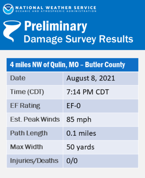
From the National Weather Service in Paducah, KY states a brief EF-0 Tornado touched down 4 miles northwest of Qulin in Butler County on Sunday evening around 7:15 p.m.. This is the same cell that passed between Malden and Bernie.
Below is the report from the National Weather Service:
...NWS DAMAGE SURVEY FOR 08/08/21 TORNADO EVENT...
.OVERVIEW...A BRIEF EF-0 TORNADO TOUCHED DOWN 4 MILES NORTHWEST OF
QULIN IN BUTLER COUNTY MISSOURI.
.TORNADO NORTHWEST OF QULIN...
RATING: EF-0
ESTIMATED PEAK WIND: 85 MPH
PATH LENGTH/STATUTE/:0.1 MILES
PATH WIDTH/MAXIMUM/: 50 YARDS
FATALITIES: 0
INJURIES: 0
START DATE: AUG 8 2021
START TIME: 7:14 PM CDT
START LOCATION: 4.3 MI NW OF QULIN, MISSOURI
START LAT/LON: 36.64 / -90.3016
END DATE: AUG 8 2021
END TIME: 7:14 PM CDT
END LOCATION: 4.3 MI NW OF QULIN, MISSOURI
END LAT/LON: 36.6404 / -90.3001
SURVEY SUMMARY:
A BRIEF TORNADO TOUCHED DOWN AT A RESIDENCE ALONG HIGHWAY 53 TO THE NORTHWEST OF QULIN, MO. IT LIFTED THE FRONT PORCH ROOF COVERING UP AND OVER THE HOUSE, CAUSING DAMAGE TO THE BACKSIDE OF THE ROOF BEFORE LANDING IN THE BACKYARD. A FEW TREES WERE SNAPPED ON THE PROPERTY AS WELL.
EF SCALE: THE ENHANCED FUJITA SCALE CLASSIFIES TORNADOES INTO THE FOLLOWING CATEGORIES.
EF0...WEAK......65 TO 85 MPH
EF1...WEAK......86 TO 110 MPH
EF2...STRONG....111 TO 135 MPH
EF3...STRONG....136 TO 165 MPH
EF4...VIOLENT...166 TO 200 MPH
EF5...VIOLENT...>200 MPH
NOTE:
THE INFORMATION IN THIS STATEMENT IS PRELIMINARY AND SUBJECT TO CHANGE PENDING FINAL REVIEW OF THE EVENT AND PUBLICATION IN NWS STORM DATA.

