ShowMe Weather
Subscribe to "ShowMe Weather"

ShowMe Gold Sponsors

Slight Risk of Severe Weather Today
June 15th 2016 by Dee Loflin
Slight Risk of Severe Weather Today
Stoddard County, Missouri -  There is a slight risk for severe storms today in the Stoddard County area.

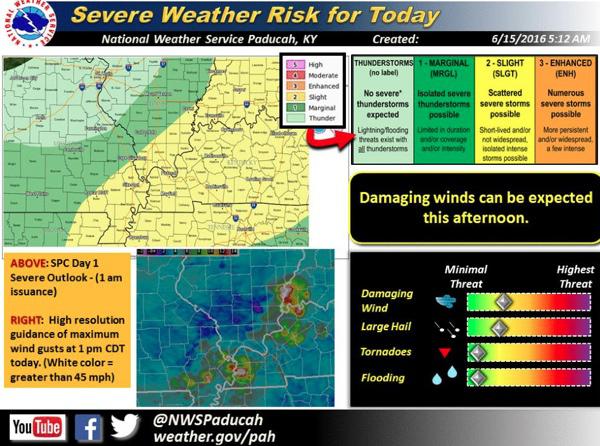
This graphic depicts an assessment of the severe weather risk today (mainly this afternoon) for the Quad State region. A majority of the area is included in a “Slight” coverage for severe storms for today.

The biggest concerns will be damaging thunderstorm wind gusts and hail. The image is in the upper left is the graphical depiction from the Storm Prediction Center of the severe weather risk today.

The legend showing what each color means is to the right of this image. To the lower right, the relative threat of various severe weather hazards (e.g., wind, hail) is shown. The image displayed on the lower left comes from a high resolution numerical computer model.

This image depicts expected wind gusts from thunderstorms around 1 pm CDT today.

The red and white spots are wind speeds between 40 and 50 mph, the lighter blue color represents winds less than 10 mph. Even though the actual winds that occur may be different than what is displayed in this image, it suggests that strong and potential severe winds will be possible this afternoon.

The SPC “Slight” Risk area shows the most likely area for these strong and damaging winds today. The time period of greatest concern for the Quad State region will range from Noon to 5 pm CDT.

Last Updated on June 15th 2016 by Dee Loflin


More from ShowMe Times:
Flash Flood Watch Issued for Stoddard County
May 26th 2016 by Dee Loflin
Flash Flood Watch Issued for Stoddard County

Stoddard County, Missouri - The National Weather Service in Paducah, Kentucky has issued a FLASH FLOOD WATCH FROM 12PM CDT THU UNTIL 8PM CDT THURSDAY!

... FLASH FLOOD WATCH IN EFFECT UNTIL 8 PM CDT THIS EVENING...

THE NATIONAL WEATHER SERVICE IN PADUCAH HAS ISSUED A

* FLASH FLOOD WATCH FOR PORTIONS OF SOUTHERN ILLINOIS... WESTERN KENTUCKY AND SOUTHEAST MISSOURI... INCLUDING THE FOLLOWING AREAS... IN SOUTHERN ILLINOIS... ALEXANDER... GALLATIN... HARDIN... JACKSON... JOHNSON... MASSAC... POPE... PULASKI... SALINE... UNION AND WILLIAMSON. IN WESTERN KENTUCKY... BALLARD... CALDWELL... CALLOWAY... CARLISLE... CHRISTIAN... CRITTENDEN... FULTON... GRAVES... HICKMAN... HOPKINS... LIVINGSTON... LYON... MARSHALL... MCCRACKEN... MUHLENBERG... TODD... TRIGG... UNION KY AND WEBSTER. IN SOUTHEAST MISSOURI... BOLLINGER... BUTLER... CAPE GIRARDEAU... CARTER... MISSISSIPPI... NEW MADRID... PERRY MO... RIPLEY... SCOTT... STODDARD AND WAYNE MO.

* UNTIL 8 PM CDT THIS EVENING

* A LINE OF THUNDERSTORMS ORIENTED FROM WEST TO EAST OVER SOUTHERN ILLINOIS WILL SAG SLOWLY SOUTH ACROSS SOUTHEAST MISSOURI AND WESTERN KENTUCKY THIS AFTERNOON. RAINFALL RATES OVER AN INCH PER HOUR WILL BE QUITE COMMON IN THE STORMS. THE LINE MAY STALL OVER PARTS OF THE REGION... CAUSING LOCALIZED FLASH FLOODING.

* THESE STORMS MAY HAVE A LARGE IMPACT ON THE EVENING COMMUTE. TRAVEL MAY BE SLOWER THAN USUAL DUE TO PONDING ON ROADS AND POOR VISIBILITY. LOCAL FLASH FLOODING MAY CAUSE SOME ROAD CLOSURES.

PRECAUTIONARY/PREPAREDNESS ACTIONS...

A FLASH FLOOD WATCH MEANS THAT CONDITIONS MAY DEVELOP THAT LEAD TO FLASH FLOODING. FLASH FLOODING IS A VERY DANGEROUS SITUATION.

YOU SHOULD MONITOR LATER FORECASTS AND BE PREPARED TO TAKE ACTION SHOULD FLASH FLOOD WARNINGS BE ISSUED.


Last Updated on May 26th 2016 by Dee Loflin


More from ShowMe Times:
Severe Thunderstorm Watch Issued for Stoddard County
May 09th 2016 by Dee Loflin
Severe Thunderstorm Watch Issued for Stoddard County

Stoddard County, Missouri - THE NATIONAL WEATHER SERVICE HAS ISSUED SEVERE THUNDERSTORM WATCH 158 IN EFFECT UNTIL 2 AM CDT TUESDAY FOR THE FOLLOWING AREAS

IN ILLINOIS THIS WATCH INCLUDES 11 COUNTIES

IN SOUTHERN ILLINOIS

ALEXANDER GALLATIN HARDIN JACKSON JOHNSON MASSAC POPE PULASKI SALINE UNION WILLIAMSON

IN KENTUCKY THIS WATCH INCLUDES 7 COUNTIES

IN WESTERN KENTUCKY

BALLARD CARLISLE FULTON GRAVES HICKMAN LIVINGSTON MCCRACKEN

IN MISSOURI THIS WATCH INCLUDES 11 COUNTIES

IN SOUTHEAST MISSOURI

BOLLINGER BUTLER CAPE GIRARDEAU CARTER MISSISSIPPI NEW MADRID PERRY RIPLEY SCOTT STODDARD WAYNE

THIS INCLUDES THE CITIES OF... BARDWELL... BLOOMFIELD... CAIRO... CAPE GIRARDEAU... CARBONDALE... CHARLESTON... CLINTON... DONIPHAN... ELIZABETHTOWN... GOLCONDA... HARRISBURG... HERRIN... HICKMAN... JACKSON... JONESBORO... LOWES... MARBLE HILL... MAYFIELD... METROPOLIS... MOUND CITY... MURPHYSBORO... NEW MADRID... PADUCAH... PERRYVILLE... PIEDMONT... POPLAR BLUFF... SHAWNEETOWN... SIKESTON... SILVER LAKE... SMITHLAND... SYMSONIA... VAN BUREN... VIENNA AND WICKLIFFE.


Last Updated on May 09th 2016 by Dee Loflin


More from ShowMe Times:
Stoddard County 5-Day Forecast
May 09th 2016 by Dee Loflin
Stoddard County 5-Day Forecast

Stoddard County, Missouri -  Five-day forecast predicts scattered thunderstorms on Monday, Tuesday and Wednesday.

Monday, May 9th -   Thunderstorms likely in the morning.  Then the chance of scattered thunderstorms this afternoon.  High 78F.  Winds south at 10 to 20 mph.  Chance of rain 80%.  Tonight a few storms may be severe.  Low near 65F.  Winds south at 10 to 20 mph.  Chance of rain 90% 

Tuesday, May 10th - Scattered showers and thunderstorms.  A few storms may be severe.  High 74F.  Winds south at 10 to 20 mph.  Chance of rain 50%.  Wednesday evening scattered showers and thunderstorms.  Low 67F.  Winds south at 5 to 10 mph.  Chance of rain 50%.

Wednesday, May 11th - Thunderstorms in the morning will give way to partly cloudy skies late.  High near 85F.  Winds SSW at 10 to 15 mph.  Chance of rain 90%.  Thursday evening mostly clear skies during the evening will give way to isolated thunderstorms overnight.  Low 67F. Winds SSW at 5 to 10 mph.  Chance of rain 30%. 

Thursday, May 12th - A stray shower of thunderstorm is possible early.  Overcast.  High 79F. Winds NW at 10 to 20 mph.  Thursday night a stray shower or thunderstorm is possible early.  A few clouds from time to time.  Low 54F. Winds NW at 5 to 10 mph.

Friday, May 13th - DEXTER GRADUATION EVENING! – A stray shower or thunderstorm is possible early.  Partly cloudy skies.  High 79F.  Winds NW at 5 to 10 mph.  Friday evening a mostly clear sky with a low of 57F.  Winds SW at 5 to 10 mph.

Saturday, May 14th - Generally sunny despite a few afternoon clouds.  High around 75F. Winds NNW at 10 to 15 mph.  Saturday night mostly clear skies in the evening then becoming cloudy overnight.  Low 52F.  Winds NNE at 5 to 10 mph.


Last Updated on May 09th 2016 by Dee Loflin


More from ShowMe Times:
Special Weather Statement for Stoddard County, Missouri
April 26th 2016 by Dee Loflin
Special Weather Statement for Stoddard County, Missouri

Stoddard County, Missouri - The National Weather Service in Paducah, Kentucky has issued a SPECIAL WEATHER STATEMENT UNTIL 6PM CDT TUE

... HEAVY RAIN UP TO AN INCH LIKELY WITH LINE OF THUNDERSTORMS THROUGH 6 PM CDT...

HEAVY RAIN... WITH RAINFALL TOTALS RANGING FROM SIX TENTHS TO ONE INCH... WILL BE LIKELY WITH THE LEADING EDGE OF THE LINE OF THUNDERSTORMS MOVING ACROSS SOUTHERN ILLINOIS... SOUTHEAST MISSOURI... SOUTHWEST INDIANA... AND NORTHWEST KENTUCKY THIS AFTERNOON.

THE HEAVY RAIN WILL LAST APPROXIMATELY A HALF HOUR BEFORE THE RAIN INTENSITY LESSENS DRAMATICALLY.

THIS RAIN WILL LIKELY OVERWHELM SMALL DITCHES AND STREAMS BRIEFLY AFTER THE STORMS ROLL THROUGH YOUR AREA. THIS MAY ALSO CAUSE MOMENTARY PONDING OF WATER ON ROADWAYS... ESPECIALLY IN URBAN AND POORLY DRAINED LOCATIONS.

IF YOU ARE ABLE... PLEASE DELAY TRAVEL UNTIL THE RAINFALL HAS TIME TO RUNOFF AND DRAIN AWAY FROM YOUR AREA. AVOID TRAVEL ON ROADS THAT ARE COVERED WITH WATER.

LIGHT RAIN WILL LIKELY FOLLOW THE HEAVY RAIN UP TO AN HOUR FOLLOWING THE PASSAGE OF THE INITIAL LINE OF THUNDERSTORMS.


Last Updated on April 26th 2016 by Dee Loflin


More from ShowMe Times:
Severe Thunderstorm Watch in Effect for Stoddard County
April 26th 2016 by Dee Loflin
Severe Thunderstorm Watch in Effect for Stoddard County

Stoddard County, Missouri - The National Weather Service in Paducah, Kentucky has issued a Severe Thunderstorm Watch for Stoddard County, Missouri.

SEVERE THUNDERSTORM WATCH FROM 11:58AM CDT TUE UNTIL 7PM CDT TUE

WATCH COUNTY NOTIFICATION FOR WATCH 106 NATIONAL WEATHER SERVICE PADUCAH KY 1158 AM CDT TUE APR 26 2016

ILC077-145-MOC017-023-031-035-157-181-207-223-270000- /O.NEW.KPAH.SV.A.0106.160426T1658Z-160427T0000Z/

THE NATIONAL WEATHER SERVICE HAS ISSUED SEVERE THUNDERSTORM WATCH 106 IN EFFECT UNTIL 7 PM CDT THIS EVENING FOR THE FOLLOWING AREAS

IN ILLINOIS THIS WATCH INCLUDES 2 COUNTIES

IN SOUTHERN ILLINOIS

JACKSON PERRY

IN MISSOURI THIS WATCH INCLUDES 8 COUNTIES

IN SOUTHEAST MISSOURI

BOLLINGER BUTLER CAPE GIRARDEAU CARTER PERRY RIPLEY STODDARD WAYNE

THIS INCLUDES THE CITIES OF... BLOOMFIELD... CAPE GIRARDEAU... CARBONDALE... DONIPHAN... JACKSON... MARBLE HILL... MURPHYSBORO... PERRYVILLE... PIEDMONT... PINCKNEYVILLE... POPLAR BLUFF... SILVER LAKE AND VAN BUREN.


Last Updated on April 26th 2016 by Dee Loflin


More from ShowMe Times:
Severe Storms Likely on Tuesday Evening into Wednesday
April 25th 2016 by Dee Loflin
Severe Storms Likely on Tuesday Evening into Wednesday

Stoddard County, Missouri - Severe thunderstorms likely on Tuesday into Wednesday. 

"Tuesday night into Wednesday is looking potentially nasty," commented Adam Clark, Central Elementary teacher and local weather enthusiast.  "I am mostly concerned about Wednesday at this point.  Looks like it won't be one storm that rolls through, could be multiple storms scattered throughout the day."  Adam is locally known as Cloudy Clark and keeps us informed of major weather happenings!

This Week's Forecast:

Monday, April 25th Mostly Sunny - High 82, Low 66

Tuesday, April 26th Scattered Thunderstorms - High 84, Low 66  50% Chance of rain

Wednesday, April 27th Thunderstorms - High 78, Low 62 90% Chance of rain

Thursday, April 28th Partly Cloudy Skies - High 87, Low 58 10% Chance of rain

Friday, April 29th Partly Cloudy - High 77, Low 62 10% Chance of rain

Saturday, April 30th Thunderstorms –-High 78, Low 62 80% Chance of rain


Last Updated on April 25th 2016 by Dee Loflin


More from ShowMe Times: