The Stoddard County Commission meeting began with the Pledge of Allegiance and a prayer.
New Business:
Proposal for Conducting a Low-to-Moderate Income (LMI) Survey for any projec related to CDGB grants moniest. The study has to be done every four years for CDBG grants for Stoddard County.
Motion to employee Bootheel Regional Planning Commission to conduct a Low-to-Moderate Income (LMI) Survey made by Commissioner C. D. Stewart, seconded by Commissioner Wes Howard. All three voted yes and motion passed.
SB40 Board
"We are trying to get a meeting with both the Sheltered Workshop and the SB40 Board; however there are people out of town etc." commented Presiding Commissioner Greg Mathis. "But we will try to meet all together."
Motion to accept the resignation of Don Abner from the SB 40 Board made by Commissioner C.D. Stewart, seconded by Commissioner Wes Howard. All voted yes and motion passed.
Motion to accept the resignation of Judy Overbey, effective June 2025, made by by Commissioner Wes Howard, seconded by Commissioner C.D. Stewart. All voted yes and motion passed.
Other Business:
Motion to accept the meeting minutes from March 31, 2025 made by Commissioner C.D. Stewart, seconded by Commissioner Wes Howard. All voted yes and motion passed.
Motion to accept the March 2025 Ads and Abates from Josh Speakman Collector/Treasurer made by Commissioner C.D. Stewart, seconded by Commissioner Wes Howard. All voted yes and motion passed.
Motion to enter into closed session at 11:00 a.m. made by Commissioner C.D. Stewart, seconded by Commissioner Wes Howard. All votes yes and motion passed.


GOVERNOR KEHOE ORDERS FLAGS TO FLY AT HALF-STAFF IN HONOR OF WHITEWATER FIRE PROTECTION DISTRICT CHIEF GARRY MOORE
Today, in honor of Whitewater Fire Protection District Chief Garry Moore, Governor Mike Kehoe ordered U.S. and Missouri flags be flown at half-staff at government buildings in Cape Girardeau County, the Fire Fighters Memorial of Missouri in Kingdom City, and firehouses statewide on Thursday, April 10, 2025, from sunrise to sunset.
“Garry Moore’s life was devoted to serving his community, state and nation,” Governor Mike Kehoe said. “He served 20 years in the U.S. Navy, during which he first joined the fire service. After retiring from the Navy, he joined the Whitewater Fire Protection District, was soon promoted to chief, and spent over three decades responding to fires and other emergencies. Selfless people like Chief Moore are the foundation upon which our strong Missouri communities are built. Claudia and I are keeping his family and community in our prayers during this difficult time.”
On April 2, Chief Moore, 68, responded to the Delta, Missouri area after an EF-2 tornado caused widespread destruction. He was fatally injured while responding to a stranded vehicle.
The flags will be held at half-staff on the day of Chief Moore’s memorial services. To view the Governor’s proclamation


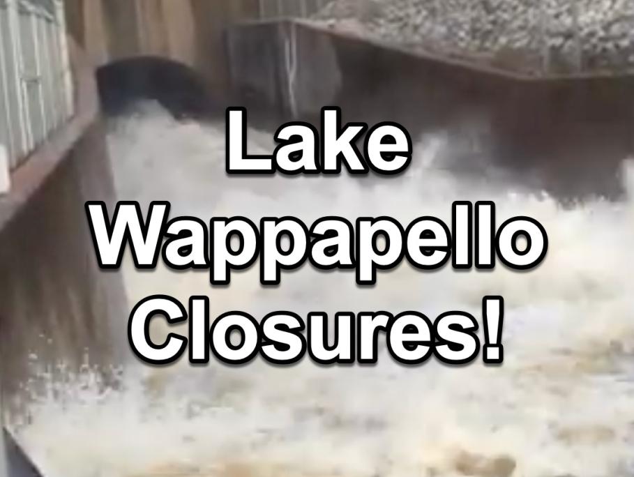
The U.S. Army Corps of Engineers has announced closures at Wappapello Lake due to rising water levels. Key recreational sites and access points are affected to ensure public safety and protect infrastructure.
The U.S. Army Corps of Engineers has announced a series of closures at Wappapello Lake as water levels are expected to crest at less than 384.5 feet on April 10. The anticipated discharge is set to reach 10,000 cubic feet per second by April 13, pending no additional rainfall in the watershed. These measures are being taken to ensure public safety and protect infrastructure as the lake experiences elevated water levels.
Flood impact levels
410.4 - Maximum Pool Level.
394.74 - Spillway Elevation.
359.74 - Recreational/Summer Pool.
Historic Crests
400.01 ft on 05-03-2011
The closures affect a wide range of recreational and access points around the lake, according to information released Sunday morning by the U.S. Army Corps of Engineers. Among the affected areas are Perkins Branch Road, Lost Creek Landing Boat Ramp, Warner Davis, and Berry Springs. Several campsites, including Island Campsites #2, #3, #4, and #5, are also closed. Popular boat ramps such as Walnut Cove, Paradise Point, and Cozart Point are inaccessible, along with numerous other locations.
These closures are part of a broader effort to manage the lake's water levels and ensure the safety of visitors. The U.S. Army Corps of Engineers has a history of implementing such measures, as seen in previous events like the cancellation of the drawdown and periodic inspection
Safety Precautions and Further Information
Visitors to Wappapello Lake are urged to exercise caution and adhere to safety guidelines. The Corps of Engineers emphasizes the importance of not driving through flooded roadways, a critical safety measure during periods of high water. For those seeking more information on the current lake level and closures, updates can be found on the U.S. Army Corps of Engineers website
As the situation evolves, the Corps will continue to monitor water levels and make adjustments as necessary to ensure public safety and the preservation of the lake's infrastructure.
Closures
- Perkins Branch Road, RD-13
- Lost Creek Landing Boat Ramp, RD-9A
- Warner Davis, RD-10
- Berry Springs, RD-16
- Island Campsites #2 & 3
- Lost Creek Low Water Bridge Boat Ramp, RD-8
- Caldwell Creek, RD-31
- Lost Creek Point, 4-Mile Road Boat Ramp, RD-11
- Possum Creek Parking Area
- Walnut Cove Boat Ramp
- Paradise Point Boat Ramp
- Cozart Point Boat Ramp
- Strickland Point Boat Ramp
- Hatties ford Road South
- Piso Point Boat Ramp
- Redman Creek Beach
- Redman Creek Fishing Pier
- Holiday Landing Bridge Site
- Island Campsite #4
- Davis Schoolhouse
- Possum Creek Boat Ramp
- Island Campsites 1 & 6
- Hatties Ford Road, North
- Lost Creek Trail
- Carlton Place
- Walnut Cove
- Page Branch Boat Ramp
- Lost Creek Landing Road to Shook
- Holliday Landing Boat Ramp
- Lost Creek Recreation Boat Ramp, Lodge
- Piso Point Boat Ramp
- Joe Bill Bluff, Sheets Hole
- County Road 543, Caldwell Creek (Wayne County)
- Blue Springs Boat Ramp
- Peoples Creek Day Use and Campground
- Rockwood Point
- Island Campsite 5
- Wet Fork Access
- Otter Creek Upper Parking Lot
- North Greenville Access
- Blue Water Creek Access
- North Haggot Hole
- 34 Bridge Recreation Area
- Sulphur Spring Boat Ramp
- Rockwood Landing
- Greenville Campground and Day-Use
- Bounds Creek
- Sundowner Boat Ramp
- North Perkins Branch Boat Ramp and Road
- Lost Creek Lodge Road/ Recreation
- Chaonia Landing


|
Route F in Stoddard County will be reduced to one lane as Missouri Department of Transportation crews perform drainage repairs. This section of roadway is located from Route 60 to County Road 468 near Dexter, Missouri. Weather permitting, work will take place Monday, March 31 through Wednesday, April 30 from 8 a.m. to 5 p.m. daily. The work zones will be marked with signs. Motorists are urged to use extreme caution while traveling near these areas. |


|
|
|
Route U in Butler and Stoddard Counties will be reduced to one lane with a 14-foot width restriction as contractor crews perform bridge maintenance. This section of roadway is located from County Road 668 in Butler County to County Road 681 in Stoddard County. Weather permitting, work will take place Thursday, March 13 and Friday, March 14 from 6:30 a.m. to 5 p.m. daily. The work zone will be marked with signs. Motorists are urged to use extreme caution while traveling near the area. For additional information, contact MoDOT’s Customer Service Center toll-free at 1-888-ASK-MODOT |


