Dee Loflin, SMT Manager/Editor
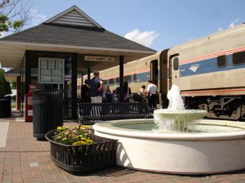
Missouri - The weather outside might get frightful, but this winter, savings on Amtrak travel are delightful. Missouri River Runner passengers can save 20 percent on adult fares for travel January 2 through March 31.
Book your seat using discount code V539 effective January 1, 2014. Reservations are required at least one day in advance of travel on the route between Kansas City and St. Louis, which includes stops at Kirkwood, Washington, Hermann, Jefferson City, Sedalia, Warrensburg, Lee's Summit and Independence.
Complete your plans now for the lowest fares. Savings are possible by booking through the "Deals" tab at Amtrak.com or by calling 800-USA-RAIL.You can also purchase tickets using Amtrak eTicketing and simply print your boarding documents from any printer or present them on board electronically via your smartphone.
Terms and conditions vary. Some blackout dates and other applicable restrictions apply, including advance reservation and purchase requirements, which are displayed on Amtrak.com. The offer is valid for coach seats and is dependent upon availability.

Dee Loflin, SMT Manager/Editor
Missouri - There are no excuses for driving drunk. The consequences are known: fines, jail time or even death.
As you prepare for your New Year's Eve, top your list with a designated driver. The Missouri Department of Transportation wants to remind those who plan to drink alcohol to designate a sober driver or call a cab.
Statewide, law enforcement is on the lookout for impaired drivers. Many municipalities will be shoring up their patrols with a focus on intoxicated drivers.
"Don't become a New Year's Eve statistic," said Dave Nichols, MoDOT director. "Last year, 12 people were killed and 63 were seriously injured in Missouri traffic crashes over the New Year's holiday."
Nichols noted that four of the fatalities and 11 of the serious injuries involved a substance-impaired driver.
"We are making a special effort to reach motorists with reminders to plan ahead if they're going to drink tonight," Nichols said. "This is a time of celebration, but it's also a time to use forethought and common sense."
Light snow is also forecasted for many parts of the state over the next 24 hours, adding to the need for caution when operating a vehicle.

Written by
Dee Loflin, SMT Manager/Editor
Dexter, Missouri – Santa has been spotted by NORAD! Did you know that children all over the United States can track Santa Clause? The North American Aerospace Defense Command (NORAD) is set to start tracking St. Nick’s travels tonight.
You can head over to NoradSanta.org to see the countdown clock ticking down to that final hour. NORAD has been tracking Santa via its high-tech instruments since 1955 with its festive annual program designed to show children how the red-suited, jolly fellow makes his way to chimneys all over the world.
Children can explore the North Pole and see Santa’s Village. There are games, movies and music to keep the children entertained for hours as they wait for Santa.
How did all this get started? Go to the Secret Santa Files and learn how Sears Roebuck & Co. misprinted a telephone number for children to call Santa. The phone number put kids through to the CONAD Commander-in-Chief’s operations “hotline”. OOPS! Not to disappoint all the children, the Director had his staff check the radar for Santa and so it became tradition. CONAD was later renamed to NORAD.
Satellites help track Rudolph’s red nose with no problem. The satellites are only 22,300 miles above the earth each with infrared sensors searching for heat. Rudolph's red nose sure puts off some heat with that GLOW!
NORAD intelligence even posts videos almost every hour on Christmas Eve of Santa making his way around the world. There is even specific technical data about Santa’s sleight. Did you know it is 75 candy canes long and 40 candy canes wide? Or that the maximum speed is faster than starlight? Or that the fuel consists of hay, oats and carrots to keep his nine reindeer in tiptop shape? There is so much to learn at NoradSanta.org. Go check it out this holiday season.
HO! HO! HO! Merry Christmas to all!
Dee Loflin, SMT Manager/Editor
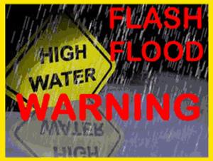
THE NATIONAL WEATHER SERVICE IN PADUCAH HAS ISSUED A FLASH FLOOD WARNING FOR... BOLLINGER COUNTY IN SOUTHEAST MISSOURI... BUTLER COUNTY IN SOUTHEAST MISSOURI... CAPE GIRARDEAU COUNTY IN SOUTHEAST MISSOURI... CARTER COUNTY IN SOUTHEAST MISSOURI... MISSISSIPPI COUNTY IN SOUTHEAST MISSOURI... NEW MADRID COUNTY IN SOUTHEAST MISSOURI... PERRY COUNTY IN SOUTHEAST MISSOURI... RIPLEY COUNTY IN SOUTHEAST MISSOURI... SCOTT COUNTY IN SOUTHEAST MISSOURI... STODDARD COUNTY IN SOUTHEAST MISSOURI... WAYNE COUNTY IN SOUTHEAST MISSOURI...
* UNTIL 100 PM CST.
* AT 656 AM CST... HEAVY RAINFALL CONTINUED TO TRACK ACROSS MUCH OF SOUTHEAST MISSOURI REPORTS OF CREEKS, DITCHES AND SMALL RIVERS APPROACHING BANKFULL OR OUT OF BANKS. SEVERAL REPORTS OF 3 TO NEARLY 4 INCHES OF RAINFALL ACCUMULATIONS HAVE BEEN RECEIVED.
* LOCATIONS IN THE WARNED AREA INCLUDE... GREENVILLE... SAM A. BAKER STATE PARK... ADVANCE... PIEDMONT... MARBLE HILL... ORAN... BOLLINGER MILL STATE HISTORIC SITE... CHAFFEE... VAN BUREN... BENTON... JACKSON... SCOTT CITY... CAPE GIRARDEAU... TRAIL OF TEARS STATE PARK... PERRYVILLE... SHOOK... LODI... GRASSY... CASCADE AND BELL CITY.
PRECAUTIONARY/PREPAREDNESS ACTIONS...
ADDITIONAL RAINFALL AMOUNTS OF 2 TO 3 INCHES ARE POSSIBLE IN THE WARNED AREA THROUGH THE MORNING HOURS.
EXCESSIVE RUNOFF FROM HEAVY RAINFALL WILL CAUSE FLOODING OF SMALL CREEKS AND STREAMS... HIGHWAYS AND UNDERPASSES. ADDITIONALLY... COUNTRY ROADS AND FARMLANDS ALONG THE BANKS OF CREEKS... STREAMS AND OTHER LOW LYING AREAS ARE SUBJECT TO FLOODING.
DO NOT DRIVE YOUR VEHICLE INTO AREAS WHERE THE WATER COVERS THE ROADWAY. THE WATER DEPTH MAY BE TOO GREAT TO ALLOW YOUR CAR TO CROSS SAFELY. MOVE TO HIGHER GROUND.
MOST FLOOD DEATHS OCCUR IN AUTOMOBILES. NEVER DRIVE YOUR VEHICLE INTO AREAS WHERE THE WATER COVERS THE ROADWAY. FLOOD WATERS ARE USUALLY DEEPER THAN THEY APPEAR. JUST ONE FOOT OF FLOWING WATER IS POWERFUL ENOUGH TO SWEEP VEHICLES OFF THE ROAD. WHEN ENCOUNTERING FLOODED ROADS MAKE THE SMART CHOICE... TURN AROUND... DONT DROWN.

Dee Loflin, SMT Manager/Editor
Flood Watch for Stoddard, MO
From 6:00 PM CST, Fri., Dec 20, 2013 until 6:00 AM CST, Sun., Dec 22, 2013
... FLOOD WATCH IN EFFECT FROM FRIDAY EVENING THROUGH LATE SATURDAY NIGHT...
THE NATIONAL WEATHER SERVICE IN PADUCAH HAS ISSUED A
* FLOOD WATCH FOR ALL OF SOUTHEAST MISSOURI... SOUTHERN ILLINOIS... SOUTHWEST INDIANA AND WESTERN KENTUCKY.
* FROM FRIDAY EVENING THROUGH LATE SATURDAY NIGHT.
* 3 TO 5 INCHES OF RAINFALL IS FORECAST FROM FRIDAY THROUGH SATURDAY NIGHT WITH THE HEAVIEST RAINFALL EXPECTED FROM LATE FRIDAY NIGHT THROUGH ABOUT MIDNIGHT SATURDAY NIGHT.
* GROUND CONDITIONS REMAIN SATURATED FROM RECENT SNOW MELT AND PAST PRECIPITATION EVENTS. HEAVY RAINFALL WILL RESULT IN CREEKS AND SMALL STREAMS COMING OUT OF THEIR BANKS. ROADS THAT TYPICALLY FLOOD... WILL DO SO DURING THIS EVENT. THE HEAVY RAIN ACROSS THE OHIO VALLEY REGION WILL LIKELY HAVE SOME INFLUENCE ON LARGER RIVERS AND THEIR LEVELS OVER THE NEXT WEEK OR SO
...HEAVY RAIN LIKELY LATE FRIDAY THROUGH EARLY SUNDAY...FLOODING POSSIBLE...RECENT PRECIPITATION AND SNOW MELT WILL COMBINE WITH EXPECTED RAINFALL LATE THIS WEEK...TO INCREASE THE CHANCE OF FLOODING. MODEL PROJECTIONS SUGGEST GENERALLY 3 TO 4 INCHES OF RAIN WILL FALL STARTING THURSDAY NIGHT...CONTINUING THROUGH EARLY SUNDAY ACROSS MOST OF SOUTHEASTERN MISSOURI...SOUTHERN ILLINOIS...SOUTHWESTERN INDIANA AND WESTERN KENTUCKY. WET SOILS WILL INCREASE THE CHANCE FOR FLASH FLOODING. DITCHES...CREEKS AND SMALLER RIVERS MAY FILL QUICKLY AND OVERFLOW. ROADS MAY BECOME WATER COVERED QUICKLY...ESPECIALLY THOSE TYPICALLY AFFECTED BY FLOOD WATERS.
LONGER RANGE MODEL OUTPUT SUGGESTS MINOR RIVER FLOODING MAY BE POSSIBLE DURING CHRISTMAS WEEK. WITH RESPECT TO THE LARGER RIVERS...ONLY LOW LAND RIVER FLOODING IS EXPECTED THAT MAY IMPACT AGRICULTURAL LAND AND A FEW ROADS CLOSEST TO THE RIVER.
WE WILL CONTINUE TO MONITOR THE LATEST FORECAST DATA...AND MAKE NECESSARY ADJUSTMENTS TO WHERE THE HEAVIEST RAIN IS EXPECTED TO OCCUR.

