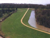
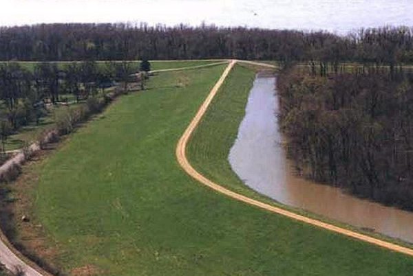
Southeast Missouri - The Missouri Department of Transportation has closed several state routes in Southeast Missouri due to the recent flooding.
In addition, motorists are encouraged to watch for flash flooding. This could cause water to quickly rise in areas that were previously safe. MoDOT crews will continually monitor state routes, but motorists are also urged to stop and turn around if they discover a roadway has high water.
Routes that are closed include:
Butler County:
Route 142-Route 67 to Route HH and north to Route 158
Route N-CRD 243 to CRD 232
Route HH-from Route H to CRD 329
Route H-from Route HH to near the end of state maintenance
Cape Girardeau County:
Kingshighway-Route 74 to Castor River Diversion Channel at Scott City
Route 177-from County Road 657 to East Cape Rock Drive in Cape Girardeau, Mo. and from Route J to CRD 610
Route 25-from County Road 216 at Dutchtown to Blomeyer roundabout
Route A-from the Route 25/A/74 junction at Dutchtown to County Road 234
Route 74-from Outer 55 to CRD 205 and the Route 25/A/74 junction at Dutchtown to CRD 214
Ramp at SB I-55 at MM 93 onto Route 74
Ramp at SB US 61/South Kingshighway onto Route 74
Carter County:
Route Y
Route M-near Rogers Creek and Mill Creek
Douglas County:
Route EE-at North Fork River; near Route AD
Route U-at Bryant Creek; south of Olathia
Route Y-at Cowskin Creek; approximately 3.5 miles after Route 76
Route 14-from Route 95 at Gentryville to Route AC
Route C-between CRD C-128 to just past the Wright/Douglas County line
Route AB-at Vera Cruz Access
Route AP-from Route 181 in Douglas County to Route 14 in Howell County
Route FF-east of Ava, Mo. at Hunter Creek
Dunklin County:
Route DD-west of Route 53; from CRD 213 to CRD 203
Howell County:
Route 142-Route E to Route FF
Route UU-from Route 63 to east of CRD 2150
Route U-from Route UU to Route N
Route 63-from West Plains to south of Willow Springs, Mo.
Route N-from Route 17 to US 63
Route CC-from Dora, Mo. in Ozark County to Route AD in Howell County
Route AP-from Route 181 in Douglas County to Route 14 in Howell County
Route Z-from Route P to Route 76
Route AB-west of Route 160
Route K-from Route KK to Route MM
Iron County:
Route D
Route F-at Crane Pond Creek
Madison County:
Route V-CRD 243 to Route F
Mississippi County:
Route 77-from Levee Road to stateline
Route 80-from Levee Road to stateline
New Madrid County:
Route 162-from CRD 439 to stateline
Route P-at St. John’s Diversion Channel from Route BB to CRD 727
Route WW-from Route P to Route AB
Oregon County:
Route 142-at Eleven Point River
Ozark County:
Route 181-at Bryant Creek at Sycamore
Route 95-at Bryant Creek; between CRD 164 and CRD 156 and at Spring Creek; between CRD 136 and CRD 138
Route H-from CRD 352 to CRD 346
Route 160-at Norfolk Lake at Tecumseh
Route JJ-from CRD 920 to CRD 916 at Thornfield, Mo.
Route CC-from Dora, Mo. in Ozark County to Route AD in Howell County
Route J-Lick Creek; north of Howards Ridge
Route PP-North Fork River; near Route 160
Perry County:
Chester Bridge on Route 51
Route E-from CRD 534 to CRD 322
Route AA-between CRD 508/510 and CRD 522
Route A-from Wittenberg to CRD 448
Route B-from Route K to CRD 5
Route C-at Menfro
Reynolds County:
Route F-at Logan Creek
Route K-east of Route O to west of CRD 440
Route B-CRD 786 to CRD 785 and CRD 758
Route HH-from Route RA in Reynolds County to Tacketts Pocket near Piedmont in Wayne County
Ripley County:
Route AA
Route H
Route W
Scott County:
Route E-at Commerce
Shannon County:
Route NN
Route 106-from Alley Spring to Route E (due to slide)
Route T-near CRD 687
Ste. Genevieve County:
Route 32-from Gisi Road to Siebert Road
Route J-from Route 61 to Buehler Road
Route 61-from Route H to Route M
Route V-from 61 to Sugar Bottom Road
Route U-at Route 61 at Saint Mary
Route M-from Route J to Eisenbeis Road
Route H-from Route 61 to Ste. Genevieve/Perry County line.
Stoddard County:
Eastbound Route 60 Ramp at Route 51 (Fisk/Puxico)
Texas County:
Route EE-from Route 181 to Route AD
Route BB-at Boiling Spring Access
Wayne County:
Route FF-CRD 378 to CRD 380
Route KK-south of CRD 456
Business 67-from Route D to US 67; near Greenville, Mo.
Route HH-from Route RA in Reynolds County to Tacketts Pocket near Piedmont in Wayne County
Route D-at East Fork Lost Creek
Route T-from the Wayne/Butler County line to Route D
Wright County:
Route AB-Wolf Creek; near Adamson Road
Route E-north of Route 60 at Norwood; near Kempt Road and Williams Road
Route Z-Elk Creek-between Emmerson Road and Clayton Road
Route C-between CRD C-128 to just past the Wright/Douglas County line
Route V-from Route 5 in Wright County to Route C in Webster County
Motorists are encouraged to use extreme caution and plan alternate routes.
MoDOT also offers the following driving tips that can help avoid delays and unsafe conditions during rainy weather:
Turn on your headlights when windshield wipers are needed. It's the law.
Slow down, use caution, and don't use cruise control when driving in rain to avoid skidding and hydroplaning.
Leave plenty of following distance behind the vehicle in front of yours.
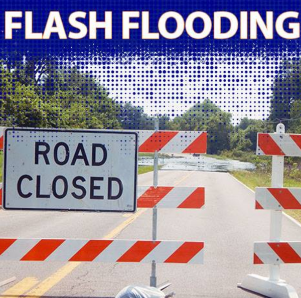
Never move or drive around barricades placed on roadways due to high water. Barricades are a warning designed to protect you from an unsafe condition. You can put yourself at serious risk if you proceed into a flooded section of road.
If a road is closed, find another route.
Do NOT drive into high water. Stop and turn around. Notify local police, the sheriff or the Missouri State Highway Patrol.
"Turn Around - Don't Drown" as highways become impassable.
For more information, please contact MoDOT's Customer Service Center toll-free at 1-888-ASK-MODOT (1-888-275-6636


EMPHASIS: Announcement Of Sobriety Checkpoint.
Police Chief Sammy Stone with the Dexter Police Department announces that sometime during the month of May, 2017, the Dexter Police Department will conduct a sobriety check point within the city limits of Dexter MO.
The operation will be conducted by the Dexter Police Department in cooperation with other local area law enforcement agencies.
The checkpoint is a static operation on a specific highway that is designed to check every driver to ensure they are sober.
The Dexter Police Department urges all citizens to report any vehicle they observe operating in a careless manner to their local authorities.
The public can contact the Dexter Police Department at 573-624-5512.


Flooded Roads in Southeast Missouri
Update May 3 at 9 p.m.
Missouri - The Missouri Department of Transportation has closed several state routes in Southeast Missouri due to the recent flooding.
In addition, motorists are encouraged to watch for flash flooding. This could cause water to quickly rise in areas that were previously safe. MoDOT crews will continually monitor state routes, but motorists are also urged to stop and turn around if they discover a roadway has high water.
Routes that are closed include:
Butler County:
Route 142-Route B in Ripley County to Route HH near Vastus in Butler County and from Route HH north to Route 158
Route N-CRD 243 to CRD 232
Route 53-from Route UU to Route 51
Route HH-from Route H to CRD 329
Route H-from Route HH to near the end of state maintenance
Cape Girardeau County:
Route N-from Route U/Route T to Route NN
Kingshighway-Route 74 to Castor River Diversion Channel at Scott City
Route 177-from CRD 651 to Cape Rock Drive in Cape Girardeau, Mo.
Route 25-from County Road 216 at Dutchtown to Blomeyer roundabout
Route A-from the Route 25/A/74 junction at Dutchtown to County Road 234
Route 74-from Outer 55 to CRD 205 and the Route 25/A/74 junction at Dutchtown to CRD 214
Carter County:
Route Y
Douglas County:
Route EE-at North Fork River; near Route AD
Route U-at Bryant Creek; south of Olathia
Route Y-at Cowskin Creek; approximately 3.5 miles after Route 76
Route 14-from Route 95 at Gentryville to Route AC
Route C-between CRD C-128 to just past the Wright/Douglas County line
Route AB-at Vera Cruz Access
Route AP-from Route 181 in Douglas County to Route 14 in Howell County
Dunklin County:
Route UU-from Route NN to CRD 711/end of state maintenance
Route DD-west of Route 53; from CRD 213 to CRD 203
Howell County:
Route 142-Route E to Route FF
Route UU-from Route 63 to east of CRD 2150
Route U-from Route UU to Route N
Route 63-from West Plains to south of Willow Springs, Mo.
Route N-from Route 17 to US 63
Route CC-from Dora, Mo. in Ozark County to Route AD in Howell County
Route AP-from Route 181 in Douglas County to Route 14 in Howell County
Route Z-from Route P to Route 76
Route AB-west of Route 160
Iron County:
Route C-east of Route 49 to west of CRD 424 in Madison County
Route D
Route F-at Crane Pond Creek
Route 143-Route 34 in Wayne County to Route 49 in Iron County
Madison County:
Route C-east of Route 49 in Iron County to west of CRD 424 in Madison County
Route V-CRD 243 to Route F
Mississippi County:
Route 77-from Levee Road to stateline
Route 80-from Levee Road to stateline
New Madrid County:
Route 162-from CRD 439 to stateline
Route P-at St. John’s Diversion Channel from Route BB to CRD 727
Ozark County:
Route 181-at Bryant Creek at Sycamore
Route 95-at Bryant Creek; between CRD 164 and CRD 156 and at Spring Creek; between CRD 136 and CRD 138
Route H-from CRD 352 to CRD 346
Route 160-at Norfolk Lake at Tecumseh
Route JJ-from CRD 920 to CRD 916 at Thornfield, Mo.
Route CC-from Dora, Mo. in Ozark County to Route AD in Howell County
Route J-Lick Creek; north of Howards Ridge
Route PP-North Fork River; near Route 160
Route O-from Route 101 at Bakersfield to end of state maintenance
Route V-from Route O to US 160
Perry County:
Route E-from CRD 534 to CRD 322
Route AA-between CRD 508/510 and CRD 522
Route A-from Wittenberg to CRD 448
Route B-from Route K to CRD 5
Route C-at Menfro
Reynolds County:
Route F-at Logan Creek
Route K-east of Route O to west of CRD 440
Route B-CRD 786 to CRD 785 and CRD 758
Route HH-from Route RA in Reynolds County to Tacketts Pocket near Piedmont in Wayne County
Ripley County:
Route 142-from Route B in Ripley County to Route HH near Vastus in Butler County (and in Butler County from Route HH north to Route 158)
Route AA
Route H
Route W
Scott County:
Route E-at Commerce
Shannon County:
Route KK-Piatt Road to Route K at Akers
Route NN
Route 106-from Alley Spring to Route E (due to slide)
Route M-from Route 60 to end of state maintenance
Ste. Genevieve County:
Route 32-from Gisi Road to Siebert Road
Route J-from Route 61 to Buehler Road
Route 61-from Route H to Route M
Route V-from 61 to Sugar Bottom Road
Route U-at Route 61 at Saint Mary
Stoddard County:
Route T-from CRD 404 in Stoddard County to the Wayne/Butler County line
Eastbound Route 60 Ramp at Route 51 (Fisk/Puxico)
Texas County:
Route EE-from Route 181 to Route AD
Wayne County:
Route 143-Route 34 in Wayne County to Route 49 in Iron County
Route FF-CRD 378 to CRD 380
Route KK-south of CRD 456
Business 67-from Route D to US 67; near Greenville, Mo.
Route 49-from Mill Spring, Mo. to CRD 440
Route HH-from Route RA in Reynolds County to Tacketts Pocket near Piedmont in Wayne County
Route D-at East Fork Lost Creek
Route T-from CRD 404 in Stoddard County to the Wayne/Butler County line
Wright County:
Route AB-Wolf Creek; near Adamson Road
Route E-Gasconade River; from Robinette Drive to north of Broyles Road
Route Z-Elk Creek-between Emmerson Road and Clayton Road
Route C-between CRD C-128 to just past the Wright/Douglas County line
Motorists are encouraged to use extreme caution and plan alternate routes.
MoDOT also offers the following driving tips that can help avoid delays and unsafe conditions during rainy weather:
Turn on your headlights when windshield wipers are needed. It's the law.
Slow down, use caution, and don't use cruise control when driving in rain to avoid skidding and hydroplaning.
Leave plenty of following distance behind the vehicle in front of yours.
Never move or drive around barricades placed on roadways due to high water. Barricades are a warning designed to protect you from an unsafe condition. You can put yourself at serious risk if you proceed into a flooded section of road.
If a road is closed, find another route.
Do NOT drive into high water. Stop and turn around. Notify local police, the sheriff or the Missouri State Highway Patrol.
"Turn Around - Don't Drown" as highways become impassable.
For more information, please contact MoDOT's Customer Service Center toll-free at 1-888-ASK-MODOT (1-888-275-6636)
Flooded Roads in Southeast Missouri
Update May 3 at 9 a.m.
SIKESTON – The Missouri Department of Transportation has closed several state routes in Southeast Missouri due to the recent flooding.
In addition, motorists are encouraged to watch for flash flooding. This could cause water to quickly rise in areas that were previously safe. MoDOT crews will continually monitor state routes, but motorists are also urged to stop and turn around if they discover a roadway has high water.
Routes that are closed include:
Butler County:
Route 158-from Route 142 to US 67
Route 142-Route B in Ripley County to Route HH near Vastus in Butler County and from Route HH north to Route 158
Route N-CRD 243 to CRD 232
Route 53-from Route UU to Route HH
Route HH-from Route H to CRD 329
Cape Girardeau County:
Route N-from Route U to Route NN and CRD 253 to CRD 254
Route HH-from Route OO to end of state maintenance
Route U-from Route T to Route A
Kingshighway-Route 74 to Castor River Diversion Channel at Scott City
Route 74-Route 25 to CRD 214
Route 177-from CRD 651 to Cape Rock Drive in Cape Girardeau, Mo.
Carter County:
Route Y
Douglas County:
Route EE-at North Fork River; near Route AD
Route U-at Bryant Creek; south of Olathia
Route Y-at Cowskin Creek; approximately 3.5 miles after Route 76
Route 14-from Route 95 at Gentryville to Route AC
Route C-between CRD C-128 to just past the Wright/Douglas County line
Route AB-at Vera Cruz Access
Route AP-from Route 181 in Douglas County to Route 14 in Howell County
Dunklin County:
Route UU-from Route NN to CRD 711/end of state maintenance
Route DD-west of Route 53; from CRD 213 to CRD 203
Howell County:
Route 142-Route E to Route FF
Route UU-from Route 63 to east of CRD 2150
Route U-from Route UU to Route N
Route 63-from West Plains to south of Willow Springs, Mo.
Route N-from Route 17 to US 63
Route CC-from Dora, Mo. in Ozark County to Route AD in Howell County
Route AP-from Route 181 in Douglas County to Route 14 in Howell County
Route Z-from Route P to Route 76
Route AB-west of Route 160
Iron County:
Route C-east of Route 49 to west of CRD 424 in Madison County
Route D
Route F-at Crane Pond Creek
Route 143-Route 34 in Wayne County to Route 49 in Iron County
Madison County:
Route C-east of Route 49 in Iron County to west of CRD 424 in Madison County
Route V-CRD 243 to Route F
Ozark County:
Route 181-from Route H at Crossroads to Route N
Route 95-at Bryant Creek; between CRD 164 and CRD 156 and at Spring Creek; between CRD 136 and CRD 138
Route H-from CRD 352 to CRD 346
Route 160-at Norfolk Lake at Tecumseh
Route JJ-from CRD 920 to CRD 916 at Thornfield, Mo.
Route CC-from Dora, Mo. in Ozark County to Route AD in Howell County
Route J-Lick Creek; north of Howards Ridge
Route PP-North Fork River; near Route 160
Route O-from Route 101 at Bakersfield to end of state maintenance
Route V-from Route O to US 160
Perry County:
Route E-from CRD 534 to CRD 322
Route AA-between CRD 508/510 and CRD 522
Route A-from Wittenberg to CRD 448
Route B-from Route K to CRD 5
Route C-at Menfro
Reynolds County:
Route F-at Logan Creek
Route K-east of Route O to west of CRD 440
Route B-CRD 786 to CRD 785 and CRD 758
Route HH-from Route RA in Reynolds County to Tacketts Pocket near Piedmont in Wayne County
Ripley County:
Route 142-at Doniphan, Mo. and Route B in Ripley County to Route HH near Vastus in Butler County
Route 21-in Doniphan, Mo.
Route A-near 21S-3 to CRD A-7
Scott County:
Route E-at Commerce
Shannon County:
Route KK-Piatt Road to Route K at Akers
Route NN
Route 106-from Alley Spring to Route E (due to slide)
Route 99-at Spring Creek; north of Route MM
Route M-from Route 60 to end of state maintenance
Ste. Genevieve County:
Route 32-from Gisi Road to Siebert Road
Route J-from Route 61 to Buehler Road
Route 61-from Route H to Route M
Route V-from 61 to Sugar Bottom Road
Stoddard County:
Route T-from CRD 404 in Stoddard County to the Wayne/Butler County line
Eastbound Route 60 Ramp at Route 51 (Fisk/Puxico)
Texas County:
Route 32-from Hillcrest Road to Mason Drive
Route EE-from Route 181 to Route AD
Wayne County:
Route 143-Route 34 in Wayne County to Route 49 in Iron County
Route FF-CRD 378 to CRD 380
Route KK-south of CRD 456
Business 67-from Route D to US 67; near Greenville, Mo.
Route 49-from Mill Spring, Mo. to CRD 440
Route HH-from Route RA in Reynolds County to Tacketts Pocket near Piedmont in Wayne County
Route D-at East Fork Lost Creek
Route T-from CRD 404 in Stoddard County to the Wayne/Butler County line
Wright County:
Route AB-Wolf Creek; near Adamson Road
Route E-Gasconade River; from Robinette Drive to north of Broyles Road
Route Z-Elk Creek-between Emmerson Road and Clayton Road
Route C-between CRD C-128 to just past the Wright/Douglas County line
Motorists are encouraged to use extreme caution and plan alternate routes.
MoDOT also offers the following driving tips that can help avoid delays and unsafe conditions during rainy weather:
Turn on your headlights when windshield wipers are needed. It's the law.
Slow down, use caution, and don't use cruise control when driving in rain to avoid skidding and hydroplaning.
Leave plenty of following distance behind the vehicle in front of yours.
Never move or drive around barricades placed on roadways due to high water. Barricades are a warning designed to protect you from an unsafe condition. You can put yourself at serious risk if you proceed into a flooded section of road.
If a road is closed, find another route.
Do NOT drive into high water. Stop and turn around. Notify local police, the sheriff or the Missouri State Highway Patrol.
"Turn Around - Don't Drown" as highways become impassable.
For more information, please contact MoDOT's Customer Service Center toll-free at 1-888-ASK-MODOT (1-888-275-6636)

Charleston, Missouri - The Mississippi County Sheriff's Department that the levee between Bird's Point - New Madrid is now closed to traffic until the river stages return to below 43 feet at Cairo and 34 feet at New Madrid.
They must maintain these precautions so no unnecessary strain is put on the levee.
The National Weather Service is now predicting the river will crest at 51 feet at Cairo on May 6th, which is well above the 40 foot flood stage. At New Madrid the river will reach 47 feet, 14.8 feet above flood stage, on May 7th.