Local News

Hunters Harvest 11,061 Deer During Alternative-Methods Portion
January 02nd 2016 by Dee Loflin
Hunters Harvest 11,061 Deer During MO Alternative-Methods Portion of Deer Season

Jefferson City, Missouri - Preliminary data from the Missouri Department of Conservation (MDC) shows that deer hunters in Missouri harvested 11,061 deer during the alternative-methods portion of the 2015-2016 Missouri firearms deer-hunting season, which ran Dec. 19-29. Of the total harvest, 2,994 were antlered bucks, 1,594 button bucks, and 6,473 does. Top harvest counties were Franklin with 260 deer harvested, Howell with 247, and Texas with 235.

The harvest total for last year's alternative-methods portion was 11,067 and consisted of 2,851 antlered bucks, 1,503 button bucks, and 6,713 does.

For 2015 harvest totals by county and season portion, visit the MDC website and under “Telecheck: Deer and Turkey Harvest Data.” For past season numbers, visit the same link under “Deer Harvest Summaries.”

Deer hunting continues for this season with statewide archery hunting through Jan. 15 and the statewide firearms late youth weekend Jan. 2-3.

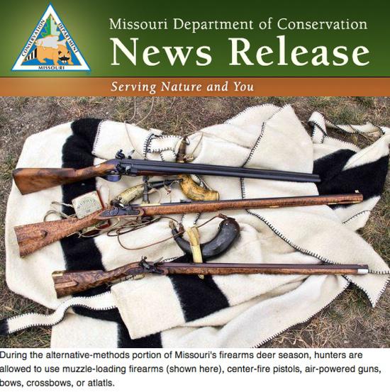
During the alternative-methods portion of firearms deer season, hunters are allowed to use muzzle-loading firearms, center-fire pistols, air-powered guns, bows, crossbows, or atlatls.

Missouri offers some of the best deer hunting in the country, and deer hunting is an important part of many Missourians' lives and family traditions. Deer hunting is also an important economic driver in Missouri and gives a $1 billion annual boost to the state and local economies. For more on Missouri deer hunting, go online to the MDC website at www.mdc.mo.gov and click on Hunting/Trapping at the top of the home page.

Press Release and Photo submitted by Joe Jerek, MDC Statewide New Service Coordinator.


Last Updated on January 02nd 2016 by Dee Loflin


Ohio River Bridge to Close at Midnight Thursday
December 30th 2015 by Dee Loflin
Ohio River Bridge to Close at Midnight Thursday

Ballard County, Kentucky - The Kentucky Transportation will close the Ohio River “Cairo” Bridge and US 51 South of Wickliffe near the Ballard-Carlisle County line at midnight on Thursday, December 31, 2015.

According to Kentucky Transportation Cabinet District #1 they are required to close US 51 at the 6-mile marker between Wickliffe and the bridge at a little over 55 feet, thus cutting off access to the bridge.

There are about 5,000 plus cars and trucks that cross the bridge each day.  Drivers are advised to plan ahead and consider alternate routes of travel.


Last Updated on December 30th 2015 by Dee Loflin


Updated Road Closures Due to High Water
December 30th 2015 by Dee Loflin
Updated Road Closures Due to High Water

Missouri - Flooded Roadways in Southeast Missouri as of 10:00 a.m. Wednesday, December 30, 2015.

Update 10 am

Flooded Roadways Southeast MO


Bollinger County

  • Route H – from CR 702 to Route 51

Butler County

  • Route 158 – from Route 67 to Route 142
  • Route 142 – from Route EE to CR 353
  • Route N – from CR 243 to CR 231
  • Route 53 – from Route HH to Route 51
  • Route MM – from CR 355 to end of state maintenance

Cape Girardeau County

  • South Kingshighway in Cape – from Route 74 to Diversion Channel
  • Route 74 – from Route 25 to Diversion Channel
  • Route U – from Route A to CR 391
  • Route 177 – from Cape Rock to CR 640
  • Route A – over Hubble Creek
  • Route 25 – from Route 74 to Blomeyer
  • Route N/U/T junction
  • Ramp I-55 SB to MO 74
  • Route 61 – right lane closed to Route 74

Carter County

  • Route M – over Mill Creek
  • Route Z – near CR 206
  • Route Z – Skyline Drive to end of state maintenance

Douglas County

  • Route Y – over Cowskin Creek
  • Route FF- over Hunter Creek
  • Route U – over Bryant Creek
  • Route EE – over North Fork River

 Dunklin County

  • Route DD – from Route 53 to CR 228
  • Route ZZ – from CR 721 to end of state maintenance
  • Route F – from Route AC to Arkansas line

 Howell County

  • Route 142 – from 17 to CR 9330

Iron County

  • Route F – from CR 164 to CR 165 (Crane Pond Creek)

Madison County

  • Route V – from Rt F to CR 243
  • Route 162 – from CR 439 to end of state maintenance

New Madrid

  • Route V – from CR 702 to CR 708
  • Route 77 – from Route A to the Ferry
  • Route 80 – from Levee Rd to end of state maintenance

Oregon County

  • Route 142 – over the Eleven Point River

Ozark County

  • Route 95 – over Bryant Creek
  • Route 95 – from Route N to CR 167
  • Route H – over North Fork River
  • Route T – from CR 527 to CR 512


Perry County

  • Route E – from CR 322 to CR 354
  • Route A – at CR 460
  • Route C – from CR 352 to CR 354
  • Route M – from CR 924 to Route H
  • Route 61 – from CR 502 to CR 506
  • Route 51 – Chester bridge
  • Route U – from Route 61 to end of state maintenance

Reynolds County

  • Route F – over Logan Creek
  • Route CC – From CR 464 to Wayne County line


Ripley County

  • Route H – from CR H-8 to Route KK
  • Route H – from Route KK to CR H-9
  • Route 142 – from Route 67 to Naylor

Scott County

  • Route E – from CR 342 to Washington Street

Shannon County

  • Route KK – over Gladder Creek
  • Route H – over Rocky Creek
  • Route NN – over Rocky Creek
  • Route HH – over Carr Creek

Ste. Genevieve County

  • Route J – from Buehler Road to Route 61
  • Route 61 – from Route M to Route H

Stoddard County

  • Route D – from CR 725 to CR 751 

Texas County

  • Route BB – over Big Piney River
  • Route U – from Route HH to Route 137

Wayne County                                                              

  • Route KK – south of CR 456
  • Route FF – from CR 380 to Route 67
  • Route C – over Bear Creek

Wright County

  • Route Z – over Elk Creek
  • Route AB – over Wolf Creek
  • Route E – from Kempt Road to Dake Road
  • Route E – from Day Road to Wylie Road

For more information, please contact MoDOT's Customer Service Center toll-free at 1-888-ASK-MODOT (1-888-275-6636) or visit the Traveler Information Map at:

http://traveler.modot.org/map/?district=SOUTHEAST


Last Updated on December 30th 2015 by Dee Loflin


Flooded Roadways in Southeast Missouri
December 29th 2015 by Dee Loflin
Flooded Roadways in Southeast Missouri

Southeast Missouri - Flooded Roadways Southeast MO


Bollinger County

  • Route H – from CR 702 to Route 51

Butler County

  • Route 158 – from Route 67 to Route 142
  • Route 142 – from Route EE to CR 353
  • Route 142 – Route 67 to Naylor City Limits
  • Route N – from CR 243 to CR 231
  • Route B – from CR 542 to Route O

Cape Girardeau County

  • Route A – from Route U to CR 255
  • South Kingshighway in Cape – from Route 74 to Diversion Channel
  • Route 74 – from Route 25 to Diversion Channel

Carter County

  • Route M – over Mill Creek
  • Route Z – near CR 206

Douglas County

  • Route Y – over Cowskin Creek
  • Route FF- over Hunter Creek
  • Route U – over Bryant Creek
  • Route EE – over North Fork River


Dunklin County

  • Route DD – from Route 53 to CR 228
  • Route ZZ – from CR 721 to end of state maintenance


Howell County

  • Route Y – from Route 60 to the Texas County line
  • Route U – from Route 60 to Route N
  • Route K – from Route KK to Route MM
  • Route 142 – over Bennetts River


Iron County

  • Route F – from CR 164 to CR 165 (Crane Pond Creek)


Madison County

  • Route V – from CR 238 to CR 243
  • Route C – from Route V to CR 238
  • Route C – From Route N to the Iron County line
  • Route O – from Route E to End of State Maintenance

New Madrid

  • Route V – from CR 702 to CR 708

Oregon County

  • Route K – over Whites Creek
  • Route 142 – over the Eleven Point River


Ozark County

  • Route 95 – over Bryant Creek
  • Route 95 – from Route N to CR 167
  • Route 181 – over Bryant Creek
  • Route H – over North Fork River
  • Route T – from CR 527 to CR 512


Perry County

  • Route E – from CR 322 to CR 354
  • Route A – at CR 460
  • Route C – from CR 352 to CR 354

Reynolds County

  • Route F – over Logan Creek
  • Route 106 – near Logan Creek
  • Route CC – From CR 465 to Wayne County line


Ripley County

  • Route K – over South Prong Beaverdam Creek
  • Route K – over Little Black River
  • Route NN – over North Prong Little Black River
  • Route H – from CR H-8 to Route KK
  • Route H – from Route KK to CR H-9

Scott County

  • Route E – from CR 342 to Washington Street

Shannon County

  • Route NN – over Rocky Creek
  • Route MM – from CR 651 to CR 99
  • Route T – over Spring Creek
  • Route N – over Spring Valley Creek


Ste. Genevieve County

  • Route C – from Lawrencton Cut Off Road to Sprott Road
  • Route 61 – from Route M to Route H


St. Francois County

  • Route 221 – over the St. Francis River
  • Route F – from Old Jackson Road to Wolf Creek Bridge


Stoddard County

  • Route K from Route M to Route BB


Texas County

  • Route BB – over Big Piney River
  • Route U – from Route HH to Route 137
  • Route VV – from Laner Road to Shepard Drive

Last Updated on December 29th 2015 by Dee Loflin


Gov. Jay Nixon Declares State of Emergency in Missouri
December 27th 2015 by Dee Loflin
Gov. Jay Nixon Declares State of Emergency in Missouri

Missouri - Gov. Jay Nixon today declared a state of emergency in Missouri as heavy rain, flooding and flash flooding continue to impact much of the state.

Heavy rains have led to widespread flooding and at least eight fatalities have been reported. More heavy rain and additional flooding is expected through Monday, and river levels are forecast to continue to rise over the next several days.

Since the latest round of severe weather began, the Missouri State Highway Patrol has conducted dozens of water rescues, and assisted in the evacuation of residents from flooded areas.  Multiple roadways have been closed due to floods and the Governor urged Missourians in flood-affected areas to avoid travel if possible.

“Widespread flooding and continued rainfall are causing very dangerous conditions across much of central and southern Missouri,” said Gov. Nixon. “Multiple fatalities due to flash flooding have already been reported, and I urge Missourians in flood-affected areas to stay alert, avoid travel if possible and never drive into a flooded roadway. With more heavy rain expected tonight and tomorrow, state emergency management personnel will be working around the clock to keep Missourians safe.”

The Governor also urged residents to use caution in northern Missouri, where snow and freezing rain are expected as temperatures drop and wind gusts increase. 

The State Emergency Operations Center has been actively monitoring the storm system, and Gov. Nixon has been receiving updates from his emergency management team to assess the current weather situation and address local needs. The team includes senior officials from the Missouri Department of Public Safety, Missouri National Guard, Missouri State Highway Patrol and the State Emergency Management Agency. The Missouri State Emergency Operations Plan also has been activated, allowing state agencies to coordinate directly with local jurisdictions to provide emergency services.

The Governor urged residents of flood-affected areas of Missouri to pay close attention to weather warnings and follow the safety instructions of local officials as the potential for additional dangerous flooding continues. Missourians, especially motorists, are encouraged to remember these important safety tips on flooding and high water:

  • Do not walk through moving water. Six inches of moving water can make you fall. If you have to walk in water, walk where the water is not moving. Use a stick to check the firmness of the ground in front of you.
  • Do not drive into flooded areas. If floodwaters rise around your car, abandon the car and move to higher ground if you can do so safely. You and the vehicle can be quickly swept away. Six inches of water will reach the bottom of most passenger cars, causing loss of control and possible stalling.
  • A foot of water will float many vehicles. Two feet of rushing water can carry away most vehicles, including sport utility vehicles and pick-ups. Even if the water appears shallow enough to cross, don’t try it. Water hides dips in the road. Worse yet, there may be no road at all under the water. Flooding can scour away the entire road surface and a significant amount of ground beneath.

Missourians who need disaster information, shelter information, and referrals are urged to call 211. The 211 service is now available throughout Missouri.


Last Updated on December 27th 2015 by Dee Loflin


Subscribe to "Local News"

ShowMe Gold Sponsors