ShowMe Weather
Snow Likely in Southeast MO on Super Bowl Sunday
February 01st 2014 by Jeff Huffman
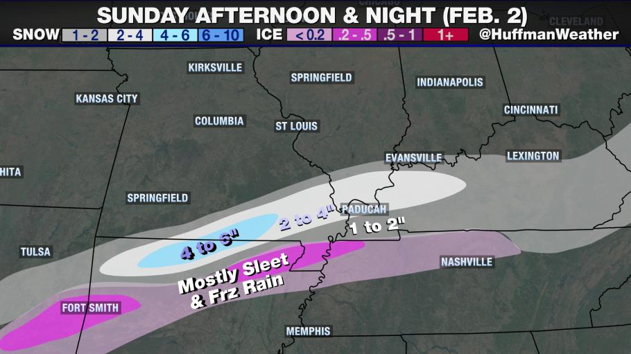
The air will likely be cold enough north and west of a Corning, AR to Sikeston, MO line for mostly sleet and snow from this event. This includes Dexter, and in these locations accumulations will range 1 to 2 inches where sleet mixes in initially, to as many as 4 inches near a Poplar Bluff to Cape Girardeau line where it will be nearly all snow. Temperatures during the event will be falling into the middle and upper 20's by Sunday evening, likely resulting in snow-covered roads through Monday morning.
TIMING AND AMOUNTS:
Margin for error is +/- 2 hours on the timing and +/- 1" on amounts
- Dexter: starts Sun 2p, ends Mon 4a - 4"
- Sikeston: starts Sun 3p, ends Mon 5a - 3" (sleet/snow mix)
- Poplar Bluff: starts Sun 1p, ends Mon 3a - 5"
- Cape Girardeau: starts Sun 6p, ends Mon 4a - 3"
- Kennett: starts Sun 2p, ends Mon 5a - 2" (sleet/snow mix)
Last Updated on February 01st 2014 by Jeff Huffman
https://showmetimes.com/Blogpost/uqil/Snow-Likely-in-Southeast-MO-on-Super-Bowl-Sunday-

