Submitted by Dee Loflin, SMT Manager/Editor
news@showmetimes.com
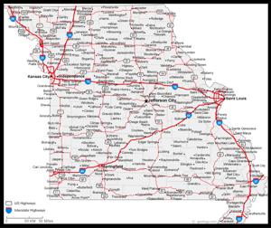
Jefferson City, Missouri - The official 2013 Missouri State Highway Map is hot off the presses and available free of charge.
The map features up-to-date route information and its cover celebrates the Missouri Department of Transportation's centennial of service.
"MoDOT has been around for a hundred years and we want to celebrate that fact with the citizens of Missouri," said Dave Nichols, director of MoDOT.
"The cover features the new Christopher S. Bond Bridge in Kansas City and has inset pictures dating back to the times when Missouri still had mud roads."
In addition to showing 33,891 miles of state-maintained routes (252 more than the last map), this edition displays several new features, including the Chicago to Kansas City Expressway (Missouri Route 110), the Stan Musial Veterans Memorial Bridge (opening in early 2014), an updated Katy Trail inset and the newly signed US Bike Route 76 Transamerica Trail in Missouri.
State parks, conservation areas, historic sites, hospitals, airports, Amtrak stations, colleges, universities and other destinations also are displayed on the map.
Other helpful bits of information include easy-to-locate emergency telephone numbers, and contact information for the Missouri State Highway Patrol and MoDOT district offices. The 2013 state highway map was printed on recycled paper using soy-based ink. It was printed by a St. Louis, Mo. company, Universal Printing.
To request a free map, contact MoDOT at 1-888-Ask MoDOT or visit www.modot.org. Sidebar: State Map History
The first Missouri road map, so far as State Highway Commission files reveal, was put out in 1851 by the federal government. Primary consideration was given to steamboat travel.
The first road map put out by the State of Missouri was in 1918. The map was printed in black and white with no photos.
25,000 copies of the 1924 map were printed, and the supply was quickly used up. That's compared to the 2.7 million printed this year.
To cover printing costs, the department sold the early maps to any individual, firm or company at cost, then allowed them to resell the maps for 25 cents to "make a fair profit."
There are two versions of the 1939 map. The maps have the same cover, but carry different information on the back.
The 1942 and 1944 maps have the same cover.
There was no map printed in 1943 because of World War II.
The 1966 map caused a bit of a stir because the cover featured two women in shorts.
A special map was printed in 2004 to commemorate the Lewis and Clark bicentennial.
Check out images from Missouri's official state highway maps here www.modot.org/historicmaps/index.htm.

