Written by
Dee Loflin, SMT Writer
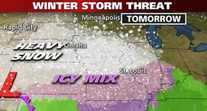
Dexter, Missouri – Well not really sure if Punxsutawney Phil had it right this year or not for Southeast Missouri as we are expecting some of that pretty white stuff to fall from the skies on Wednesday night, Thursday morning.
The National Weather Service in Paducah, Kentucky has issued a Special Weather Statement for Stoddard County, Missouri.
A powerful weather system will move from southern California through the desert southwest and onward to the Texas and Oklahoma Panhandles by late Wednesday.
It will bring a light wintry mix to the quad state region beginning late tonight and through the midday hours on Thursday.
A mix of snow and sleet will be likely over Southeast Missouri after midnight with minor accumulations possible west of the Mississippi before daybreak Thursday.
At this time, the best accumulations of snow and sleet will be over Southeast Missouri ranging from ½ inch to 1½ inches.
A Winter Weather Advisory has already been posted for Carter, Ripley, Wayne and Butler Counties between 3 a.m. and noon on Thursday.
By late morning on Thursday temperatures will continue to warm from south to north, changing the wintry mix to pure rain.
For those planning travel north and west early Thursday morning, please allow a little extra time to reach your destination. Some untreated roadways may be slick due to the sleet. Conditions should improve by Thursday afternoon.
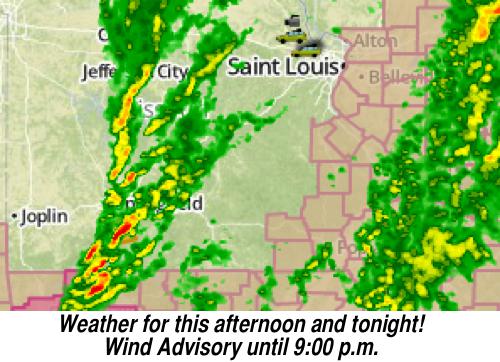
Dexter, Missouri - The National Weather Service has issued a Wind Advisory until 9:00 p.m. this evening. Winds south 20 to 35 MPH with gusts between 35 to 45 MPH.
A WIND ADVISORY is issued when sustained winds are expected to reach 30 MPH or greater for longer than one hour......or wind gusts are expected to reach 45 MPH for any duration.
Occasional showers and possibly a thunderstorm before midnight. Low around 32 degrees. Breezy, with a south wind 13 to 22 MPH becoming west northwest after midnight. Chance of precipitation is 100%.
The National Weather Service has also issued a Hazardous Weather Outlook for Wednesday night and Thursday. There is a 70% chance of rain/sleet aka, wintery weather in Southeast Missouri!

Dee Loflin, SMT Writer
Dexter, Missouri - The City of Dexter would like to announce that their offices will be closed on Monday, February 18th in observance of Presidents' Day.
Did you know that this holiday is actually designated as “Washington’s Birthday” and is a Federal Holiday according to section 6103(a) of title 5 of the United States Code, which is the law that specifies holidays for Federal employees? Though states and local governments and even private businesses may use other names, such as Presidents’ Day, it is the U.S.’s policy to always refer to holidays by the names designated in the law. It was made a federal holiday in 1885; however the District of Columbia did start celebrating Washington’s Birthday in 1880 which is February 22nd.
In 1968 Congress enacted the Uniform Monday Holiday Act. They moved Washington’s Birthday to the 3rd Monday in February each year. This meant it would fall between February 15th and February 21st each year and never actually land on Washington’s true birthday. As for the state of Missouri, we have designated it as Washington’s Birthday and all federal, state, local municipalities and schools are closed. Of course there are always exceptions.
So how did we end up calling it President’s Day? When the Uniform Monday Holiday Act was enacted it created three-day holidays for Memorial Day, Veterans Day and Washington’s Birthday. Some states were already celebrating Lincoln’s Birthday and Washington’s Birthday and when they made the holiday on the third Monday, many folks thought they were combining the two. Some states dropped Lincoln's Birthday as a holiday and it became known as Presidents’ Day. As society became more tv and radio savvy with advertising, the Presidents’ Day Sales began emerging.
There is still much controversy in the political ranks as to what the day should be called and what day we should celebrate. Even this week, Rep. Frank Wolf (R-VA) reintroduced legislation calling for George Washington’s birthday to be celebrated on his actual birthday of February 22nd. He is a longtime admirer of Washington’s life and leadership and has advocated for moving the date of this holiday for years. He even testified on the topic at a House Oversight and Government Reform Committee hearing in 2012.

So whatever day we call it or whatever day we actually observe, we should remember that George Washington was our first President of the United States and since that inauguration we have had a long line of presidents in a country that we are so very proud of and free to vote as we so choose. Like a marriage, for better or worse, until death do we part, we should be proud to be Americans and living in the greatest nation on this earth. Who knew that after 200 years we would still be discussing George Washington's Birthday and when to celebrate it.
Happy Presidents' Day and Happy Birthday George!

Dee Loflin, SMT Writer
Dexter, Missouri - Tracy Horton and Christy Dorton were the guests readers for this week's Children's Story Hour at the Keller Public Library on Tuesday.
The theme of this week’s library hour was “Roses and Valentines”. Tracy Horton read the book, “Roses are Pink, Your Feet Really Stink” by Diane de Groat.
The book is about poor little Gilbert who had to eat lunch by himself and everyone seemed to ignore him at recess. Gilbert’s problems all came about because of something he did. He wrote mean Valentine’s cards to two of his classmates and then did not sign his name, but sign their name to the cards.
Once his friends, Margaret and Lewis, figured out that it was Gilbert who wrote the cards, everyone got mad at him. Gilbert finally told them that he only did it because Margaret teased him about his glasses and Lewis was mean to him.
Margaret and Lewis never knew that the things they did hurt poor little Gilbert’s feelings. Now that everyone knew how each other felt, they all said they were sorry to each other and had a wonderful Valentine’s Day party!
The children enjoyed the book and listening to Tracy read. The children sang songs too. "Five Little Valentines at the Store" sung to the tune of "Five Little Monkeys Jumpin' on the Bed", and Ten Little Valentine sung to "Ten Little Indians".
They stood in a circle and sang "Pass the Heart" as each child handed a heart to the next. When the music stopped the one with the heart could enter Valentine's Land.
After singing a few songs and stretching, they made crafts. There were big hearts and little hearts, red ones and pink ones...lots of hearts for all the boys and girls.
Each child decorated their hearts with sprinkles, cute little owls and tiny purple and pink hearts. They even had marshmallow treats shaped like hearts.
Next week on Tuesday, February 12th at 10:15 a.m. Belinda Worley will be the guest reader with "Valentines and Hearts".
Check out the ShowMe Times Facebook page for more pictures of the Story Hour event and the wonderful children.

Written by
Dee Loflin, SMT Writer
Dexter, Missouri – February is Earthquake Awareness Month in Missouri and the Great Central U.S. ShakeOut Earthquake Drill is set for today at 10:30 a.m. CST.
Most area schools including the Dexter Public School system and several local businesses will be participating in this annual drill. According to the website, www.shakeout.org/centralus. Over 350,000 Missourians are registered to participate in the Great Central U.S. ShakeOut Drill.
Missouri is only one of nine states taking part in this “DROP, COVER, HOLD ON” technique that will last about 60 seconds. Students will be taught to DROP to the ground, take COVER by getting under a sturdy desk or table, HOLD ON to it until the shaking tops.
Today is the 201st anniversary of the largest earthquake to ever occur in Missouri, the famous New Madrid Earthquake. Many folks from southeast Missouri know the history of the earthquake, some even have heard of many tales passed down from grandparents and great-grandparents. There are many stories of how the Mississippi River flowed backwards for days and how our local fishing holes were created.
Even a few local residents remember the The Great Non-Event of 1990 as it is known today. A prediction of a major earthquake was set for December 3, 1990 and New Madrid, Missouri became the center of attention in the news media. But what did come out of all that was "AWARENESS". People learned about being prepared for an earthquake, whether they lived in Southeast Missouri or on the coast of California.
Earthquake Awareness Month is a great opportunity for schools and families to practice and discuss preparedness so that they know what to do before, during and after an earthquake.

The New Madrid Seismic Zone, centered in southeast Missouri, is the nation’s most active earthquake zone east of the Rocky Mountains. You can visit the Department of Natural Resources’ website for information about the science and history of earthquakes in the state at http://dnr.mo.gov/geology/geosrv/earthquakes.htm.
Also, SEMA is using Facebook (www.facebook.com/MissouriShakeOut) and Twitter (www.twitter.com/MOShakeOut) to provide additional information about earthquakes, earthquake preparedness and updates about the ShakeOut. This will continue through the month of February.

