Local News
Bargain Hunters Alert: 100-Mile Sale Begins!
May 26th 2011 by News
By Annabeth Miller,
ShowMe Times Editor
Bargain hunters on full alert: The annual 100-Mile Yard Sale is ready to begin!!
The Memorial Weekend tradition stretches from Jackson in the north, and follows Highway 25 through Delta, Advance, Bloomfield, and Dexter and continues south through Bernie, Malden, and Holcomb and finally ends in Kennett.
Along the way shoppers will find card tables set up in yards, tents full of “stuff” along the side of roads, and groups of folks selling everything from family treasures to treasured junk.
Chambers of Commerce directors along the sale route say those driving the 100-mile route will often find vendors at church parking lots, grouped together and that many often have their yard sales off the highway in communities along the way.
In Dexter the Chamber of Commerce is sponsoring space for yard sale vendors at the Stoddard County Fairgrounds, just east of Highway 25. Restrooms, concessions, inside and outside booth space, with plenty of parking are all available through the Chamber.
According to the Dexter Chamber, vendors can rent a space at the Fairgrounds for just $20 a day; all three days of the sale is just $50. Persons interested should contact the Dexter Chamber at 573.624.7458.
Use Caution Along 25
The 100-Mile Yard Sale can be a fun time for those hunt for treasures and collectables, but drivers should all remember that the greatest savings of the event could be a life.
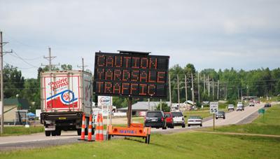
"It's a fun weekend that people look forward to each year," says Traffic Engineer Craig Compas, "but we want people to remember that there's more traffic and more congestion along Route 25 this weekend than any other and drivers need to keep that in mind."
MoDOT will do its part to bring the safety message to the forefront. Message boards will be in place along the route to alert drivers of the unusual traffic patterns and promote safe driving.
"We really want drivers to be alert-to be aware of their surroundings, to be aware of sudden stops and to look for pedestrian traffic," Compas says. "It's a big event locally, and we want everyone to enjoy themselves and be as safe as possible."
For more information, contact Compas at (573) 472-5310 or call MoDOT's Customer Service Center toll-free at 1-888-ASK-MODOT (1-888-275-6636).
The sale begins in earnest on Friday, with folks checking out the bargains throughout the holiday weekend. It’s highly recommended that buyers bring cash, since many “yard sale merchants” will not accept personal checks or credit and debit cards.
Photo Above: A MoDOT urging roadway safety along Highway 25 south of Dexter is visible for all the 100-Mile Yard Sale and others on the busy highway.
Last Updated on May 26th 2011 by Staff Writer
https://showmetimes.com/Blogpost/uiqh/Bargain-Hunters-Alert-100Mile-Sale-Begins
Storms Cause Major Damage In Area
May 25th 2011 by Staff Writer

As the clouds rolled through the area, the line of storms brought about more storm warnings than normally experienced. Local news broadcasts began at 5:00 PM and continued to after 7:30 PM strictly reporting of different storm cells from St. Louis down through Northeast Arkansas.
As the radar screen began to clear and the storm warnings were lifted, locals began to venture out into their yards and to inspect of any damage created by the storm. Throughout the community, broken branches as well as large trees were dropped in yards. Various building damage could be seen in certain area in the Northern section of town.
As a popular locally owned agricultural business, the Mule Barn owners and friends were immediately busy taking necessary steps to clean up the storm damage.
The Mule Barn is located 3 miles North of Hwy 60 on State Hwy F near Aid, Missouri.
Last Updated on May 25th 2011 by Staff Writer
https://showmetimes.com/Blogpost/uiq5/Storms-Cause-Major-Damage-In-Area
Local Churches Cancel Wednesday Events
May 25th 2011 by News
Due to severe weather forcasted for our region for Wednesday evening at soe area churches have reported cancellations to the ShowMe Times.
The ShowMe Times has been informed of the following cancellations:
- All functions at the First Baptist Church in Dexter
- The Chancel Choir at the First United Methodist Church in Dexter is cancelled. Choir Director MaryRuth Boone said "stay home and stay safe."
- The 6:30 Hope Epidemic Chapel service at the Sikeston First United Methodist Church
- All activities at the Risen Church (2nd General Church) in Dexter have been cancelled Wednesday evening.
- The Ecumenical Prayer Service at 6 p.m. this evening at the First Christian Church (Disciples of Christ) in Dexter has been postponed.
A major severe weather outbreak is expected across the region today and this evening. Storms are expected to quickly develop into supercells over southeast Missouri and southwest Illinois early this afternoon. These storms will move northeast across the area at 35 to 45 MPH. Individuals in the area should be on the alert all day Wednesday for severe weather and take necessary shelter if necessary.
Churches and organizations cancelling activities may send information to the ShowMe Times and information be updated.Please send information to amiller@showmetimes.com
Last Updated on May 25th 2011 by News
https://showmetimes.com/Blogpost/uiq3/Local-Churches-Cancel-Wednesday-Events
WEATHER STATUS BRIEFING: Noon 05252011
May 25th 2011 by Staff Writer
A STORM SHELTER HAVE BEEN OPENED IN THE FOLLOWING AREAS:
1. DEXTER AT THE FIRST BAPTIST
2. BLOOMFIELD CITY HALL
3. ADVANCE 1ST BAPTIST CHURCH
4. PUXICO LIFE CHAPEL ASSEMBLY
5. BERNIE COMMUNITY CENTER
6. DUDLEY—RICHLAND GRAIN
KDEX IS UPDATING THE PUBLIC OF THE SITUATION.
----------------------------------------------------------------------
A major severe weather outbreak is expected across the Quad State region today and this evening. Storms are expected to quickly develop into supercells over southeast Missouri and southwest Illinois late this morning or early this afternoon. These storms will move northeast across the area at 35 to 45 MPH.
More development will be possible farther east across the region later this afternoon. Any storm will be capable of producing strong long track tornadoes, very large hail 2" or greater in diameter, and damaging straight-line winds. Everyone is encouraged to keep abreast of the weather today and know where to take safe shelter no matter where they are today.
A final broken line of severe storms along a dry line will enter southeast Missouri around 5 PM. This line of storms will move east across the area through the evening. All severe weather should be east of the area by Midnight.
Last Updated on May 25th 2011 by Staff Writer
https://showmetimes.com/Blogpost/uiq2/WEATHER-STATUS-BRIEFING--Noon-05252011
WEATHER STATUS BRIEFING: From SCAD
May 25th 2011 by Staff Writer
A major severe weather outbreak is expected across the Quad State region today and this evening. Storms are expected to quickly develop into supercells over southeast Missouri and southwest Illinois late this morning or early this afternoon. These storms will move northeast across the area at 35 to 45 MPH.
More development will be possible farther east across the region later this afternoon. Any storm will be capable of producing strong long track tornadoes, very large hail 2" or greater in diameter, and damaging straight-line winds.
Everyone is encouraged to keep abreast of the weather today and know where to take safe shelter no matter where they are today. A final broken line of severe storms along a dry line will enter southeast Missouri around 5 PM.
This line of storms will move east across the area through the evening. All severe weather should be east of the area by Midnight.
HAZARDOUS WEATHER OUTLOOK
NATIONAL WEATHER SERVICE PADUCAH KY
813 AM CDT WED MAY 25 2011
COUNTIES EFFECTED: JEFFERSON-WAYNE IL-EDWARDS-WABASH-PERRY IL-FRANKLIN-HAMILTON- WHITE-JACKSON-WILLIAMSON-SALINE-GALLATIN-UNION IL-JOHNSON-POPE- HARDIN-ALEXANDER-PULASKI-MASSAC-GIBSON-PIKE-POSEY-VANDERBURGH- WARRICK-SPENCER-FULTON-HICKMAN-CARLISLE-BALLARD-MCCRACKEN-GRAVES- LIVINGSTON-MARSHALL-CALLOWAY-CRITTENDEN-LYON-TRIGG-CALDWELL- UNION KY-WEBSTER-HOPKINS-CHRISTIAN-HENDERSON-DAVIESS-MCLEAN- MUHLENBERG-TODD-PERRY MO-BOLLINGER-CAPE GIRARDEAU-WAYNE MO-CARTER- RIPLEY-BUTLER-STODDARD-SCOTT-MISSISSIPPI-NEW MADRID- 813 AM CDT WED MAY 25 2011
...AREA UPGRADED TO HIGH RISK...
...WIDESPREAD SEVERE THUNDERSTORMS EXPECTED THIS AFTERNOON AND EVENING...THIS HAZARDOUS WEATHER OUTLOOK IS FOR PORTIONS OF SOUTHERN ILLINOIS...SOUTHWEST INDIANA...WESTERN KENTUCKY AND SOUTHEAST MISSOURI.
WEDNESDAY, MAY 25, 2011 ...TODAY AND TONIGHT
THE ENTIRE QUAD STATE AREA IS IN A HIGH RISK OF SEVERE WEATHER TODAY AND TONIGHT. THIS IS A PARTICULARLY DANGEROUS SITUATION...AS THE POTENTIAL EXISTS FOR A SIGNIFICANT AND WIDESPREAD SEVERE WEATHER EVENT ACROSS THE REGION. SOME LOCATIONS MAY EXPERIENCE 2 OR 3 SEPARATE ROUNDS OF SEVERE WEATHER THROUGH THIS EVENING.
SCATTERED THUNDERSTORMS WILL DEVELOP OVER SOUTHEAST MISSOURI AND SOUTHERN ILLINOIS...POSSIBLY AS EARLY AS THE LATE MORNING HOURS. VERY STRONG WIND FIELDS AND PLENTIFUL INSTABILITY WILL ALLOW THE STORMS TO QUICKLY BECOME SEVERE...WITH LARGE HAIL...STRONG TORNADOES...AND DAMAGING WINDS. THE STORMS WILL MOVE RAPIDLY NORTHEAST ACROSS THE QUAD STATE REGION THROUGH THE AFTERNOON. OTHER SEVERE THUNDERSTORMS MAY DEVELOP FARTHER EAST ACROSS THE AREA DURING THE AFTERNOON.
FINALLY...A LINE OF SEVERE STORMS WITH AN INCREASING DAMAGING WIND THREAT WILL MOVE INTO WESTERN PORTIONS OF THE AREA AROUND 5 PM...AND THEN SWEEP THROUGH THE ENTIRE AREA THROUGH THE EVENING. TORNADOES...LARGE HAIL...AND HEAVY RAINFALL WILL ALSO BE POSSIBLE WITH THIS LINE. THE SEVERE WEATHER THREAT SHOULD BE EAST OF THE ENTIRE AREA BY MIDNIGHT.
OUTSIDE OF THUNDERSTORMS...STRONG SOUTH WINDS ARE EXPECTED TO GUST 25 TO 35 MPH THROUGH THE DAY AND INTO THE EARLY EVENING. CONSULT THE LAKE WIND ADVISORY FOR DETAILS.
MAY 26 THROUGH MAY 31: DAYS TWO THROUGH SEVEN...THURSDAY THROUGH TUESDAY
A FEW THUNDERSTORMS WILL BE POSSIBLE AS AN UPPER LEVEL LOW PRESSURE SYSTEM MOVES EAST THROUGH THE REGION THURSDAY. ANY THUNDERSTORMS ARE EXPECTED TO REMAIN BELOW SEVERE LIMITS.
ANOTHER UPPER LEVEL STORM SYSTEM WILL SWEEP THROUGH THE AREA WITH A CHANCE OF THUNDERSTORMS FRIDAY NIGHT. AT THIS TIME...SEVERE WEATHER IS NOT EXPECTED.
Last Updated on May 25th 2011 by Staff Writer
https://showmetimes.com/Blogpost/uipt/WEATHER-STATUS-BRIEFING--From-SCAD

