The population center of the nation remains in Missouri, just a little south and west of it’s previous location.
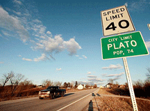
Plato, Missouri, population 109, is the new geographic center of the population of the United States. The community is located in Texas County, and is near Success, Roby and Lynchburg.
U.S. Census Bureau Director Robert Groves congratulated the southeast Missouri town during a news conference Thursday.
"2010 is a special decade in our nation’s history," Groves said. "The center of the population has moved in a southerly direction in the most extreme way we've ever seen."
The Census Bureau calculates the center of population after each decennial census. It determines the center based on where an "imaginary, flat, weightless and rigid map of the United States would balance perfectly" if all 308,745,538 residents weighed the same amounts.
The center has been located in Missouri since the 1980 census.
After analyzing the data from the 2010 Census, the new population center is 2.7 miles northeast of Plato in Texas County, Missouri.
The announcement was made today at the National Press Club in Washington, DC, by U.S. Census Director Robert Groves.
 “It’s a unique distinction for our congressional district to contain the population center of the entire country, and I think it is in many ways fitting that the center falls right in the middle of the Heartland,” U.S. Rep. Jo Ann Emerson said.
“Our congressional district is a patriotic place, we are home to strong communities, we place a high value on public service, and, to me, we represent the very heart and soul of our nation. No matter where you live in America, you would find a warm welcome if you came to Plato and sat down for coffee in the morning.”
Emerson also noted that the southward shift of the population center reflects the growth of population in southern U.S. states.
“It’s just a short drive from Edgar Springs to Plato in Missouri, but you think about the larger demographic shift in our country. It kind of boggles your mind to think about the movement of millions of people around our country and how we can simply represent that with the mean population center statistic. This is a great teaching tool for our local schools as well as for students around the nation who are learning more about the makeup of our country’s population and how the trends affect our national identity,” she said.
Ever since Chestertown, Md., was determined to be the center of population after the first census was conducted in 1790, the center of population has told the story of America, illustrating how we've grown as a nation. It follows a trail across the country — across Maryland, Virginia, West Virginia, Ohio, Kentucky, Indiana and Missouri — that reflects our history of settling the frontier, manifest destiny, waves of immigration and regional migration.
The Census Bureau reports it will install a commemorative “geodetic control mark” at a site near the official coordinates during a dedication ceremony in April 2011. This survey disc will be used by satellites and land surveyors to conduct scientific surveys to generate precise position data that serve as the foundation for accurate mapping and charting in America.

