
Stoddard County, MO - The National Weather Service in Paducah, KY has issued a Special Weather Statement for Stoddard County, MO.
Description
...WINTER WEATHER SYSTEM TO AFFECT THE AREA TONIGHT THROUGH SUNDAY...
We continue to monitor a winter weather system forecast to affect the area tonight through Sunday. Considerable uncertainty remains with respect to snowfall. The trend in the forecast data is for lower snow amounts. But that could still change.
The first round will be tonight into Saturday, as a transition from rain to a mix and then snow is forecast to occur from north to south across the four state region. Some areas in southern Illinois, southwest Indiana and southeast Missouri could see 1 to locally 2 inches of snow. However, much of this may be confined to grassy, elevated surfaces, as temperatures are forecast to be in the lower to mid 30s. Impacts to travel may be minimal. But a few slick spots cannot be ruled out.
For Saturday night through Sunday, the snow chances shift south. We cannot rule out a couple of inches of snow, and some travel impacts from the Land Between the Lakes area east to Hopkinsville. Meanwhile, for the Purchase area of west Kentucky into the southern tip of Illinois, west toward Sikeston Missouri, there may not be much in the way of snow accumulation with this storm system. But that could change if the storm track shifts. Continue to monitor the forecast closely today and this evening.

Stoddard County, MO - The National Weather Service in Paducah, KY has issued a Winter Weather Advisory until 4 p.m. today, Thursday, December 6, 2022.
Description
...WINTER WEATHER ADVISORY REMAINS IN EFFECT FROM 6 AM THIS MORNING TO 4 PM CST THIS AFTERNOON...
WHAT...Snow expected. Total snow accumulations of 1 to 3 inches. Highest amounts are expected across west Kentucky.
WHERE...Portions of southwest Indiana, southeast Missouri, western Kentucky and southern Illinois
WHEN...From 6 AM to 4 PM CST Thursday.
IMPACTS...Plan on slippery road conditions. The hazardous conditions could impact the morning commute.
PRECAUTIONARY/PREPAREDNESS ACTIONS...
Slow down and use caution while traveling.

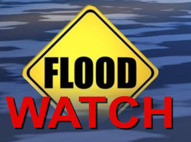
Stoddard County, MO - The national Weather Service in Paducah, KY has issued a Flood Watch for Stoddard County, Missouri.
Description
...FLOOD WATCH IN EFFECT FROM FRIDAY EVENING THROUGH SATURDAY AFTERNOON...
WHAT...Flooding caused by excessive rainfall is possible.
WHERE...Portions of southern Illinois south of Interstate 64, all of southwest Indiana, western Kentucky, and southeast Missouri.
WHEN...From Friday evening through Saturday afternoon.
IMPACTS...Flooding may occur in poor drainage and urban areas. Low-water crossings may be flooded. Tornado debris in the affected areas of western Kentucky could impede drainage.
ADDITIONAL DETAILS... - Widespread rainfall amounts of 2 to 4 inches are expected, with locally higher amounts possible. - http://www.weather.gov/safety/flood
PRECAUTIONARY/PREPAREDNESS ACTIONS...
You should monitor later forecasts and be alert for possible Flood Warnings. Those living in areas prone to flooding should be prepared to take action should flooding develop.
More Information
.A slow-moving cold front will be preceded by a surge of tropical moisture, which will result in widespread heavy rainfall and likely some flooding problems.
Stoddard County, MO - The National Weather Service in Paducah, KY has issued a Flood Watch for Stoddard County.
Affected Area
Portions of southern Illinois and southeast Missouri, including the following areas, in southern Illinois, Alexander, Franklin, Hamilton, Jackson, Johnson, Pulaski, Saline, Union and Williamson. In southeast Missouri, Bollinger, Butler, Cape Girardeau, Carter, Perry MO, Ripley, Scott, Stoddard and Wayne MO
Description
...FLOOD WATCH IN EFFECT THROUGH LATE TONIGHT...
WHAT...Flooding caused by excessive rainfall is possible.
WHERE...Portions of southern Illinois and southeast Missouri, including the following areas, in southern Illinois, Alexander, Franklin, Hamilton, Jackson, Johnson, Pulaski, Saline, Union and Williamson. In southeast Missouri, Bollinger, Butler, Cape Girardeau, Carter, Perry MO, Ripley, Scott, Stoddard and Wayne MO.
WHEN...Through late tonight.
IMPACTS...Excessive runoff may result in flooding of rivers, creeks, streams, and other low-lying and flood-prone locations. Flooding may occur in poor drainage and urban areas. Low-water crossings may be flooded.
ADDITIONAL DETAILS... - Multiple rounds of of heavy rain will be possible late this afternoon and overnight, especially where thunderstorms repeat over the same locations. Rain totals of 2 to 3 inches are expected in many locations. Locally higher amounts of 3 to 5 inches cannot be ruled out. - http://www.weather.gov/safety/flood
PRECAUTIONARY/PREPAREDNESS ACTIONS...
You should monitor later forecasts and be alert for possible Flood Warnings. Those living in areas prone to flooding should be prepared to take action should flooding develop.

Stoddard County, MO - The National Weather Service in Paducah, KY has issued a Wind Advisory until 3 a.m. Thursday morning.
Description
...WIND ADVISORY REMAINS IN EFFECT UNTIL 3 AM CST THURSDAY...
WHAT...South winds 15 to 30 mph with gusts from 40 to 45 mph expected.
WHERE...Most of southern Illinois and southeast Missouri.
WHEN...Until 3 AM CST Thursday.
IMPACTS...Gusty winds could blow around unsecured objects. Tree limbs could be blown down and a few power outages may result.
ADDITIONAL DETAILS...High profile vehicles and tractor trailers should use extra caution. Dangerous high wave conditions are expected on area lakes too.
PRECAUTIONARY/PREPAREDNESS ACTIONS...
Use extra caution when driving, especially if operating a high profile vehicle. Secure outdoor objects.

THE NATIONAL WEATHER SERVICE HAS ISSUED TORNADO WATCH 552 IN EFFECT UNTIL 11 PM CST THIS EVENING FOR THE FOLLOWING AREAS
IN ILLINOIS THIS WATCH INCLUDES 19 COUNTIES
IN SOUTHEAST ILLINOIS
EDWARDS
IN SOUTHERN ILLINOIS
ALEXANDER FRANKLIN GALLATIN HAMILTON HARDIN JACKSON JEFFERSON JOHNSON MASSAC PERRY POPE PULASKI SALINE UNION WABASH WAYNE WHITE WILLIAMSON
IN INDIANA THIS WATCH INCLUDES 6 COUNTIES
IN SOUTHWEST INDIANA
POSEY
IN SOUTHWEST INDIANA
GIBSON PIKE SPENCER VANDERBURGH WARRICK
IN KENTUCKY THIS WATCH INCLUDES 19 COUNTIES
IN WESTERN KENTUCKY
BALLARD CALDWELL CALLOWAY CARLISLE CRITTENDEN DAVIESS FULTON GRAVES HENDERSON HICKMAN HOPKINS LIVINGSTON LYON MARSHALL MCCRACKEN MCLEAN TRIGG UNION WEBSTER
IN MISSOURI THIS WATCH INCLUDES 11 COUNTIES
IN SOUTHEAST MISSOURI
BOLLINGER BUTLER CAPE GIRARDEAU CARTER MISSISSIPPI NEW MADRID PERRY RIPLEY SCOTT STODDARD WAYNE
THIS INCLUDES THE CITIES OF ALBION, BARDWELL, BENTON, BLOOMFIELD, BOONVILLE, CADIZ, CAIRO, CALHOUN, CAPE GIRARDEAU, CARBONDALE, CARMI, CHARLESTON, CLINTON, DIXON, DONIPHAN, EDDYVILLE, ELIZABETHTOWN, EVANSVILLE, FAIRFIELD, FORT BRANCH, GOLCONDA, GRAYVILLE, HARRISBURG, HENDERSON, HERRIN, HICKMAN, JACKSON, JONESBORO, MADISONVILLE, MARBLE HILL, MARION, MAYFIELD, MCLEANSBORO, METROPOLIS, MORGANFIELD, MOUND CITY, MOUNT CARMEL, MOUNT VERNON, MURPHYSBORO, MURRAY, NEW MADRID, OWENSBORO, PADUCAH, PERRYVILLE, PETERSBURG, PIEDMONT, PINCKNEYVILLE, POPLAR BLUFF, POSEYVILLE, PRINCETON, ROCKPORT, SHAWNEETOWN, SIKESTON, SMITHLAND, VAN BUREN, VIENNA, WEST FRANKFORT, WEST SALEM, AND WICKLIFFE.
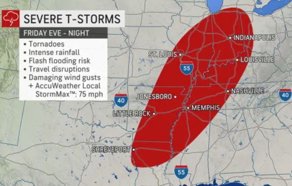
Stoddard County, MO - The National Weather Service has issued a Hazardous Weather Outlook for this evening in Stoddard County, Missouri.
...Storms with Damaging Winds and Tornadoes Possible This Evening and Overnight...
This Hazardous Weather Outlook is for portions of southern Illinois, southwest Indiana, western Kentucky, and southeast Missouri.
.DAY ONE...Today and Tonight
An organized outbreak of severe thunderstorms is possible starting this evening and continuing overnight. The main hazards will be damaging winds and tornadoes, including the potential for a couple of strong, destructive tornadoes.
Thunderstorms are expected to develop by late today into the early evening across southeast Missouri and southern Illinois and possibly far west Kentucky, then continue through the overnight hours across southwest Indiana and the rest of western Kentucky. Conditions will be favorable for damaging winds and tornadoes along a broken line of storms, and a couple long-track tornadoes are possible.
Outside of thunderstorms, strong gradient non-thunderstorm wind gusts of 30 to 40 mph are possible this evening into early Saturday morning.
SPOTTER INFORMATION STATEMENT...
Spotter activation will likely be needed this evening and overnight.

