
THE NATIONAL WEATHER SERVICE HAS ISSUED TORNADO WATCH 552 IN EFFECT UNTIL 11 PM CST THIS EVENING FOR THE FOLLOWING AREAS
IN ILLINOIS THIS WATCH INCLUDES 19 COUNTIES
IN SOUTHEAST ILLINOIS
EDWARDS
IN SOUTHERN ILLINOIS
ALEXANDER FRANKLIN GALLATIN HAMILTON HARDIN JACKSON JEFFERSON JOHNSON MASSAC PERRY POPE PULASKI SALINE UNION WABASH WAYNE WHITE WILLIAMSON
IN INDIANA THIS WATCH INCLUDES 6 COUNTIES
IN SOUTHWEST INDIANA
POSEY
IN SOUTHWEST INDIANA
GIBSON PIKE SPENCER VANDERBURGH WARRICK
IN KENTUCKY THIS WATCH INCLUDES 19 COUNTIES
IN WESTERN KENTUCKY
BALLARD CALDWELL CALLOWAY CARLISLE CRITTENDEN DAVIESS FULTON GRAVES HENDERSON HICKMAN HOPKINS LIVINGSTON LYON MARSHALL MCCRACKEN MCLEAN TRIGG UNION WEBSTER
IN MISSOURI THIS WATCH INCLUDES 11 COUNTIES
IN SOUTHEAST MISSOURI
BOLLINGER BUTLER CAPE GIRARDEAU CARTER MISSISSIPPI NEW MADRID PERRY RIPLEY SCOTT STODDARD WAYNE
THIS INCLUDES THE CITIES OF ALBION, BARDWELL, BENTON, BLOOMFIELD, BOONVILLE, CADIZ, CAIRO, CALHOUN, CAPE GIRARDEAU, CARBONDALE, CARMI, CHARLESTON, CLINTON, DIXON, DONIPHAN, EDDYVILLE, ELIZABETHTOWN, EVANSVILLE, FAIRFIELD, FORT BRANCH, GOLCONDA, GRAYVILLE, HARRISBURG, HENDERSON, HERRIN, HICKMAN, JACKSON, JONESBORO, MADISONVILLE, MARBLE HILL, MARION, MAYFIELD, MCLEANSBORO, METROPOLIS, MORGANFIELD, MOUND CITY, MOUNT CARMEL, MOUNT VERNON, MURPHYSBORO, MURRAY, NEW MADRID, OWENSBORO, PADUCAH, PERRYVILLE, PETERSBURG, PIEDMONT, PINCKNEYVILLE, POPLAR BLUFF, POSEYVILLE, PRINCETON, ROCKPORT, SHAWNEETOWN, SIKESTON, SMITHLAND, VAN BUREN, VIENNA, WEST FRANKFORT, WEST SALEM, AND WICKLIFFE.
Stoddard County, MO - The National Weather Service has issued a Hazardous Weather Outlook for this evening in Stoddard County, Missouri.
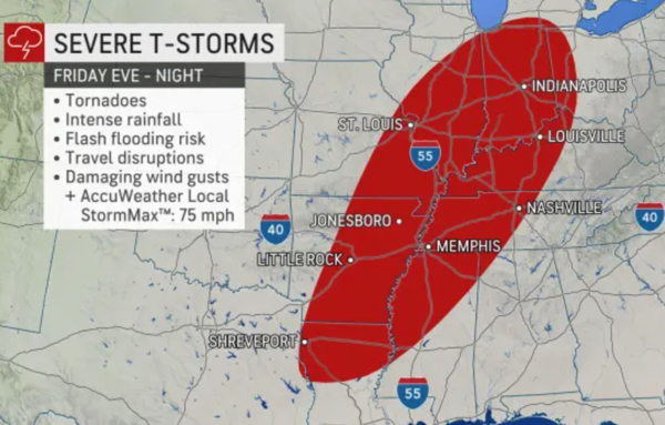
...Storms with Damaging Winds and Tornadoes Possible This Evening and Overnight...
This Hazardous Weather Outlook is for portions of southern Illinois, southwest Indiana, western Kentucky, and southeast Missouri.
.DAY ONE...Today and Tonight
An organized outbreak of severe thunderstorms is possible starting this evening and continuing overnight. The main hazards will be damaging winds and tornadoes, including the potential for a couple of strong, destructive tornadoes.
Thunderstorms are expected to develop by late today into the early evening across southeast Missouri and southern Illinois and possibly far west Kentucky, then continue through the overnight hours across southwest Indiana and the rest of western Kentucky. Conditions will be favorable for damaging winds and tornadoes along a broken line of storms, and a couple long-track tornadoes are possible.
Outside of thunderstorms, strong gradient non-thunderstorm wind gusts of 30 to 40 mph are possible this evening into early Saturday morning.
SPOTTER INFORMATION STATEMENT...
Spotter activation will likely be needed this evening and overnight.

THE NATIONAL WEATHER SERVICE HAS ISSUED TORNADO WATCH 551 IN EFFECT UNTIL 4 AM CST MONDAY FOR THE FOLLOWING AREAS
IN ILLINOIS THIS WATCH INCLUDES 10 COUNTIES
IN SOUTHERN ILLINOIS
ALEXANDER GALLATIN HARDIN JOHNSON MASSAC POPE PULASKI SALINE UNION WILLIAMSON
IN KENTUCKY THIS WATCH INCLUDES 22 COUNTIES
IN WESTERN KENTUCKY
BALLARD CALDWELL CALLOWAY CARLISLE CHRISTIAN CRITTENDEN DAVIESS FULTON GRAVES HENDERSON HICKMAN HOPKINS LIVINGSTON LYON MARSHALL MCCRACKEN MCLEAN MUHLENBERG TODD TRIGG UNION WEBSTER
IN MISSOURI THIS WATCH INCLUDES 10 COUNTIES
IN SOUTHEAST MISSOURI
BOLLINGER BUTLER CAPE GIRARDEAU CARTER MISSISSIPPI NEW MADRID RIPLEY SCOTT STODDARD WAYNE
THIS INCLUDES THE CITIES OF BARDWELL, BENTON, BLOOMFIELD, CADIZ, CAIRO, CALHOUN, CAPE GIRARDEAU, CHARLESTON, CLINTON, DIXON, DONIPHAN, EDDYVILLE, ELIZABETHTOWN, ELKTON, GOLCONDA, GREENVILLE, HARRISBURG, HENDERSON, HERRIN, HICKMAN, HOPKINSVILLE, JACKSON, JONESBORO, MADISONVILLE, MARBLE HILL, MARION, MAYFIELD, METROPOLIS, MORGANFIELD, MOUND CITY, MURRAY, NEW MADRID, OWENSBORO, PADUCAH, PIEDMONT, POPLAR BLUFF, PRINCETON, SHAWNEETOWN, SIKESTON, SMITHLAND, VAN BUREN, VIENNA, AND WICKLIFFE.

Stoddard County, MO - The National Weather Service in Paducah, KY has issued a Special Weather Statement for Stoddard County.
...Isolated thunderstorms expected today, with a few storms producing small hail...
An impressive early December weather disturbance will move across the Quad State region today.
There appears to be enough cold and unstable air aloft with this disturbance to generate a few thunderstorms as the system moves through the area.
Although the thunderstorms are expected to remain below severe limits, a few of the thunderstorms may generate some very small hail.
Rainfall associated with this fast moving weather system will remain quite light, generally a tenth of an inch or less.
The entire weather system should move east of the Quad State region by sunset today.

Stoddard County, MO - The National Weather Service in Paducah, KY has issued a Special Weather Statement for Stoddard County, Missouri.
...Wind Gusts 30 to 40 mph possible across parts of the Quad State region today...
Widespread wind gusts of 20 to 30 mph are expected to develop over parts of southeast Missouri and southwest Illinois around or slightly before 6 am CST, spreading south and east through the day in advance of a fast moving weather system crossing the area.
As the day progresses, wind gusts between 25 and 35 mph will become more common.
Wind gusts approaching or briefly exceeding 40 mph may be possible in an area stretching along and south of a line from Naylor, Poplar Bluff and Cape Girardeau in southeast Missouri, onward to Vienna in southern Illinois, and stretching northeast to Henderson and Owensboro in northwest Kentucky today.
The strongest winds will likely develop over southeast Missouri near 8 am CST and spread quickly across parts of extreme southern Illinois, the Purchase and Pennyrile areas of west Kentucky through 1 pm CST.
Some of the wind gusts may be locally enhanced by nearby shower activity.
The gusty winds will likely toss around unsecured objects left outdoors and could break small tree limbs. If these tree limbs fall on power lines, a brief interruption in electricity may result.
Drivers of high profile vehicles may experience difficulty driving due to the stronger winds.
These winds should rapidly subside after sunset across the Quad State region.

For those of you that are preparing for the return to Standard Time (or not) this weekend, it is always good to make sure you have a fresh set of batteries in your NOAA Weather Radio in the event of Severe or Winter Weather! Also don't forget to change those filters on your returns and furnaces! Check those smoke detectors as well and make sure the batteries are new.
Before you go to bed on Saturday night, turn your clocks one hour back. Your cell phones should automatically update at 2 a.m. Sunday morning.
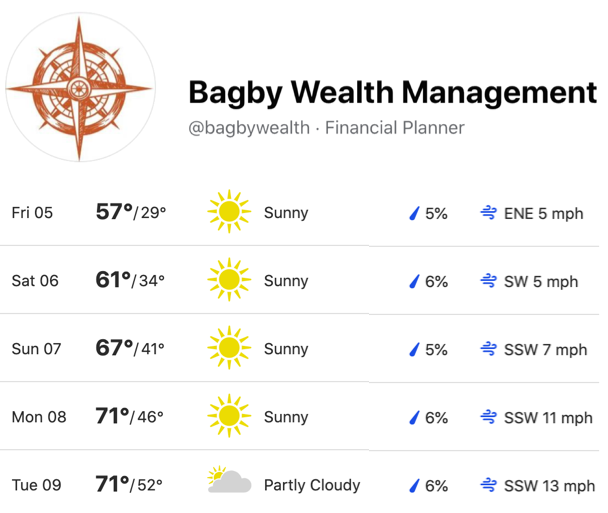
5-Day Forecast for Stoddard County, MO November 5th - 9th, 2021 Weather provided by Bagby Wealth Management.

