
Stoddard County, Missouri - The National Weather Service in Paducah, Kentucky has issued a Heat Advisory until 7 p.m. for Stoddard County.
...HEAT ADVISORY REMAINS IN EFFECT UNTIL 7 PM CDT MONDAY...
* HEAT INDEX...AFTERNOON VALUES WILL TOP OUT FROM 100 TO 105 DEGREES THROUGH MONDAY. LITTLE RELIEF IS EXPECTED AT NIGHT.
* IMPACTS...THE COMBINATION OF HOT TEMPERATURES AND HIGH HUMIDITY WILL LEAD TO AN INCREASED RISK OF HEAT RELATED STRESS AND ILLNESS. THE VERY YOUNG, THE ELDERLY, THOSE WITHOUT AIR CONDITIONING, AND THOSE PARTICIPATING IN STRENUOUS OUTDOOR ACTIVITIES WILL BE THE MOST SUSCEPTIBLE. ALSO, CAR INTERIORS CAN REACH LETHAL TEMPERATURES IN A MATTER OF MINUTES. PRECAUTIONARY/PREPAREDNESS ACTIONS
... TAKE EXTRA PRECAUTIONS.
..IF YOU WORK OR SPEND TIME OUTSIDE. WHEN POSSIBLE
...RESCHEDULE STRENUOUS ACTIVITIES TO EARLY MORNING OR EVENING. KNOW THE SIGNS AND SYMPTOMS OF HEAT EXHAUSTION AND HEAT STROKE.
WEAR LIGHT WEIGHT AND LOOSE FITTING CLOTHING WHEN POSSIBLE AND DRINK PLENTY OF WATER. MAKE SURE OUTDOOR PETS HAVE PLENTY OF SHADE AND FRESH WATER.


Stoddard County, Missouri - The National Weather Service in Paducah, Kentucky has issued a Tornado Watch until 8 p.m. for Stoddard County.
TORNADO WATCH 138 REMAINS VALID UNTIL 8 PM CDT THIS EVENING FOR THE FOLLOWING AREAS IN ILLINOIS THIS WATCH INCLUDES 8 COUNTIES IN SOUTHERN ILLINOIS ALEXANDER FRANKLIN JACKSON JOHNSON PERRY PULASKI UNION WILLIAMSON IN MISSOURI THIS WATCH INCLUDES 11 COUNTIES IN SOUTHEAST MISSOURI BOLLINGER BUTLER CAPE GIRARDEAU CARTER MISSISSIPPI NEW MADRID PERRY RIPLEY SCOTT STODDARD WAYNE THIS INCLUDES THE CITIES OF BLOOMFIELD, CAIRO, CAPE GIRARDEAU, CARBONDALE, CHARLESTON, DONIPHAN, HERRIN, JACKSON, JONESBORO, MARBLE HILL, MOUND CITY, MURPHYSBORO, NEW MADRID, PERRYVILLE, PIEDMONT, PINCKNEYVILLE, POPLAR BLUFF, SIKESTON, VAN BUREN, VIENNA, AND WEST FRANKFORT.
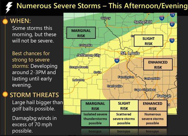

Stoddard County, Missouri - The National Weather Service in Paducah, Kentucky has issued a Severe Thunderstorm Watch for Stoddard County until 8 p.m.
THE NATIONAL WEATHER SERVICE HAS ISSUED SEVERE THUNDERSTORM WATCH 110 IN EFFECT UNTIL 8 PM CDT THIS EVENING FOR THE FOLLOWING AREAS IN ILLINOIS THIS WATCH INCLUDES 15 COUNTIES IN SOUTHERN ILLINOIS ALEXANDER FRANKLIN GALLATIN HAMILTON HARDIN JACKSON JOHNSON MASSAC PERRY POPE PULASKI SALINE UNION WHITE WILLIAMSON IN INDIANA THIS WATCH INCLUDES 3 COUNTIES IN SOUTHWEST INDIANA POSEY IN SOUTHWEST INDIANA VANDERBURGH WARRICK IN KENTUCKY THIS WATCH INCLUDES 17 COUNTIES IN WESTERN KENTUCKY BALLARD CALDWELL CALLOWAY CARLISLE CRITTENDEN FULTON GRAVES HENDERSON HICKMAN HOPKINS LIVINGSTON LYON MARSHALL MCCRACKEN TRIGG UNION WEBSTER
IN MISSOURI THIS WATCH INCLUDES 6 COUNTIES IN SOUTHEAST MISSOURI BUTLER CAPE GIRARDEAU MISSISSIPPI NEW MADRID SCOTT STODDARD
THIS INCLUDES THE CITIES OF BARDWELL, BENTON, BLOOMFIELD, BOONVILLE, CADIZ, CAIRO, CAPE GIRARDEAU, CARBONDALE, CARMI, CHARLESTON, CLINTON, DIXON, EDDYVILLE, ELIZABETHTOWN, EVANSVILLE, GOLCONDA, HARRISBURG, HENDERSON, HERRIN, HICKMAN, JACKSON, JONESBORO, MADISONVILLE, MARION, MAYFIELD, MCLEANSBORO, METROPOLIS, MORGANFIELD, MOUND CITY, MURPHYSBORO, MURRAY, NEW MADRID, PADUCAH, PINCKNEYVILLE, POPLAR BLUFF, POSEYVILLE, PRINCETON, SHAWNEETOWN, SIKESTON, SMITHLAND, VIENNA, WEST FRANKFORT, AND WICKLIFFE.

Stoddard County, Missouri - The National Weather Service in Paducah, Kentucky has issued a Severe Thunderstorm Watch for Stoddard County, Missouri.
THE NATIONAL WEATHER SERVICE HAS ISSUED SEVERE THUNDERSTORM WATCH 107 IN EFFECT UNTIL 8 PM CDT THIS EVENING FOR THE FOLLOWING AREAS IN KENTUCKY THIS WATCH INCLUDES 4 COUNTIES IN WESTERN KENTUCKY CARLISLE FULTON GRAVES HICKMAN IN MISSOURI THIS WATCH INCLUDES 8 COUNTIES IN SOUTHEAST MISSOURI BUTLER CARTER MISSISSIPPI NEW MADRID RIPLEY SCOTT STODDARD WAYNE THIS INCLUDES THE CITIES OF BARDWELL, BLOOMFIELD, CHARLESTON, CLINTON, DONIPHAN, HICKMAN, MAYFIELD, NEW MADRID, PIEDMONT, POPLAR BLUFF, SIKESTON, AND VAN BUREN.

