
Stoddard County, Missouri - The National Weather Service in Paducah, Kentucky has issued a Special Weather Statement until 4:15 p.m. for Stoddard County, Missouri.
SPECIAL WEATHER STATEMENT UNTIL 4:15PM CDT THU
... HEAT INDEX VALUES FROM 100 TO 105 BOTH THIS AFTERNOON AND FRIDAY AFTERNOON...
MORE HEAT AND HUMIDITY IS ON THE WAY FOR THE QUAD STATE REGION TODAY AND FRIDAY AS AN UPPER LEVEL HIGH PRESSURE SYSTEM BUILDS ACROSS THE SOUTHEAST UNITED STATES.
AFTERNOON TEMPERATURES RUNNING FROM NEAR 90 TO THE LOWER 90S WILL COMBINE WITH HIGH HUMIDITY LEVELS TO PRODUCE HEAT INDICES IN THE 100 TO 105 RANGE.
A FEW LOCATIONS MAY EXPERIENCE A HEAT BREAKING SHOWER OR THUNDERSTORM. WHERE STORMS DO MANAGE TO OCCUR... TORRENTIAL RAINFALL RATES CAN BE EXPECTED.
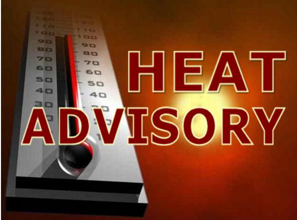
Stoddard County, Missouri - The National Weather Service in Paducah, Kentucky has issued a HEAT ADVISORY!
* TEMPERATURES/HEAT INDEX... TEMPERATURES CLIMBING INTO THE LOWER TO MID 90 COMBINED WITH VERY HUMID CONDITIONS WILL LEAD TO HEAT INDICES FROM 105 TO 108 THIS AFTERNOON OVER MOST OF SOUTHEAST MISSOURI... FAR SOUTHERN ILLINOIS... AND FAR WESTERN KENTUCKY.
* IMPACTS... A HEAT INDEX OF 105 DEGREES IS CONSIDERED THE LEVEL AT WHICH THE BODY BECOMES MORE SUSCEPTIBLE TO THE HEAT. TAKE EXTRA PRECAUTIONS... IF YOU WORK OR SPEND TIME OUTSIDE. WHEN POSSIBLE... RESCHEDULE STRENUOUS ACTIVITIES TO EARLY MORNING OR EVENING. DRINK PLENTY OF FLUIDS. LEAVING A PERSON OR PET IN AN ENCLOSED VEHICLE FOR EVEN A SHORT TIME CAN BE DEADLY. A HEAT ADVISORY MEANS THAT A PERIOD OF HOT TEMPERATURES IS EXPECTED. THE COMBINATION OF HOT TEMPERATURES AND HIGH HUMIDITY WILL COMBINE TO CREATE A SITUATION IN WHICH HEAT ILLNESSES ARE POSSIBLE. DRINK PLENTY OF FLUIDS... STAY IN AN AIR-CONDITIONED ROOM... STAY OUT OF THE SUN... AND CHECK UP ON RELATIVES AND NEIGHBORS. MAKE SURE OUTDOOR PETS HAVE PLENTY OF FRESH WATER.

Stoddard County, Missouri - The National Weather Service in Paducah, Kentucky has issued a Heat Advisory until 8:00 p.m.
HEAT ADVISORY FROM 1:05PM CDT THU UNTIL 8PM CDT FRI THE NATIONAL WEATHER SERVICE IN PADUCAH HAS ISSUED A HEAT ADVISORY...WHICH IS IN EFFECT UNTIL 8 PM CDT FRIDAY. * TEMPERATURES CLIMBING INTO THE LOWER HALF OF THE 90 COMBINED WITH VERY HUMID CONDITIONS WILL LEAD TO AFTERNOON HEAT INDICES AROUND 105 BOTH TODAY AND FRIDAY. A FEW LOCATIONS DOWN NEAR THE ARKANSAS BORDER AND NEAR THE BOOTHEEL OF MISSOURI MAY SEE INDICES CLOSER TO 110 DEGREES. * A HEAT INDEX OF 105 DEGREES IS CONSIDERED THE LEVEL AT WHICH THE BODY BECOMES MORE SUSCEPTIBLE TO THE HEAT. TAKE EXTRA PRECAUTIONS...IF YOU WORK OR SPEND TIME OUTSIDE. WHEN POSSIBLE...RESCHEDULE STRENUOUS ACTIVITIES TO EARLY MORNING OR EVENING. KNOW THE SIGNS AND SYMPTOMS OF HEAT EXHAUSTION AND HEAT STROKE. WEAR LIGHT WEIGHT AND LOOSE FITTING CLOTHING WHEN POSSIBLE AND DRINK PLENTY OF WATER. A HEAT ADVISORY MEANS THAT A PERIOD OF HOT TEMPERATURES IS EXPECTED. THE COMBINATION OF HOT TEMPERATURES AND HIGH HUMIDITY WILL COMBINE TO CREATE A SITUATION IN WHICH HEAT ILLNESSES ARE POSSIBLE. DRINK PLENTY OF FLUIDS...STAY IN AN AIR-CONDITIONED ROOM...STAY OUT OF THE SUN...AND CHECK UP ON RELATIVES AND NEIGHBORS.

Stoddard County, Missouri - The National Weather Service in Paducah, Kentucky has issued a Special Weather Statement until 4:00 p.m. today.
SPECIAL WEATHER STATEMENT UNTIL 4PM CDT THU ...HEAT INDEX CLIMBING TO BETWEEN 100 AND 105 TODAY AND FRIDAY... AN UPPER LEVEL HEAT DOME OF HIGH PRESSURE SYSTEM CURRENTLY CENTERED OVER THE SOUTHERN PLAINS STATES WILL BEGIN TO EXPAND EAST INTO THE REGION DURING THE NEXT DAY OR TWO. THIS WILL RESULT IN AFTERNOON HEAT INDICES IN THE 100 TO 105 RANGE IN MANY LOCATIONS ALONG AND WEST OF THE MISSISSIPPI RIVER BOTH TODAY AND FRIDAY. FRIDAY SHOULD BE THE HOTTEST AFTERNOON...AND A HEAT ADVISORY MAY BE REQUIRED IN THE NEAR FUTURE. ONLY SMALL CHANCES EXIST FOR A HEAT BREAKING THUNDERSTORM IN A FEW SPOTS.

Stoddard County, Missouri - Expect thunderstorms and scattered rain showers for the next seven days in Stoddard County, Missouri. Below is the local forecast by the National Weather Service.
Monday, July 25, 2016 - Scattered Thunderstorms with variable clouds. High 88F. Winds Southwest at 5 to 10 mph. Chance of rain 60%. Monday evening variable clouds with scattered thunderstorms. Low 74F. Winds light and variable. Chance of rain 40%.
Tuesday, July 26, 2016 - Thunderstorms likely in the morning. Then the chance of scattered thunderstorms in the afternoon. High 87F. Winds light and variable. Chance of rain 80%. Tuesday evening partly to mostly cloudy with scattered showers and thunderstorms developing late at night. Low 74F. Winds light and variable.
Wednesday, July 27, 2016 - Scattered thunderstorms. High 88F. Winds light and variable. Chance of rain 60%. Wednesday evening scattered thunderstorms, especially in the evening. Low 74F. Winds light and variable. Chance of rain 40%.
Thursday, July 28, 2016 - Scattered thunderstorms. High 83F with winds SSW at 5 to 10 mph. Chance of rain 60%. Thursday evening scattered showers and thunderstorms with a low of 72F. Winds light and variable with a chance of rain 60%.
Friday, July 29, 2016 - Variable clouds with scattered thunderstorms. High around 85F with winds SW at 5 to 10 mph. Chance of rain 60%. Friday night scattered showers and thunderstorms, mainly overnight. Low 71F with winds light and variable. Chance of rain 40%.
Saturday, July 30, 2016 - Clouds with scattered thunderstorm. High 84F. Winds SW at 5 to 10 mph. Chance of rain 40%. Saturday evening partly cloudy with a low of 71F.
Sunday, July 31, 2016 - Isolated thunderstorms in the morning then skies turning partly cloudy late. High around 85F with winds S at 5 to 10 mph. Chance of rain 30%. Sunday evening becoming partly cloudy with isolated thunderstorms developing overnight. Low 72F. Winds SSW at 5 to 10 mph. Chance of rain 30%.
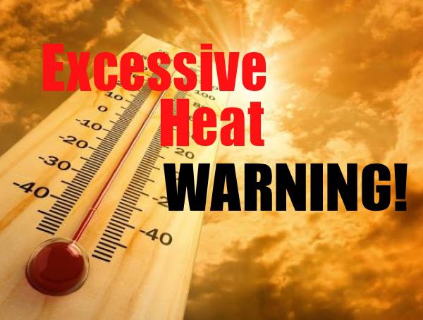
Stoddard County, Missouri - The National Weather Service in Paducah, Kentucky has issued an Excessive Heat Warning for our area until Sunday.
EXCESSIVE HEAT WARNING UNTIL 8PM CDT SUN
* THE COMBINATION OF HIGH TEMPERATURES IN THE MID TO UPPER 90S WILL COMBINE WITH OPPRESSIVE HUMIDITY TO PRODUCE HEAT INDICES FROM 105 TO 110 DEGREES.
* A HEAT INDEX OF 105 DEGREES OR HIGHER IS CONSIDERED THE LEVEL AT WHICH THE BODY BECOMES MORE SUSCEPTIBLE TO HEAT EXHAUSTION AND HEAT STROKE. YOUNG CHILDREN AND PETS SHOULD NEVER BE LEFT UNATTENDED IN VEHICLES UNDER ANY CIRCUMSTANCES. THIS IS ESPECIALLY TRUE DURING WARM OR HOT WEATHER WHEN CAR INTERIORS CAN REACH LETHAL TEMPERATURES IN A MATTER OF MINUTES.
DRINK PLENTY OF FLUIDS... STAY IN AN AIR-CONDITIONED ROOM... STAY OUT OF THE SUN... AND CHECK UP ON RELATIVES AND NEIGHBORS. MAKE SURE OUTDOOR PETS HAVE PLENTY OF FRESH WATER.
TAKE EXTRA PRECAUTIONS... IF YOU WORK OR SPEND TIME OUTSIDE. WHEN POSSIBLE... RESCHEDULE STRENUOUS ACTIVITIES TO EARLY MORNING OR EVENING. KNOW THE SIGNS AND SYMPTOMS OF HEAT EXHAUSTION AND HEAT STROKE. WEAR LIGHT WEIGHT AND LOOSE FITTING CLOTHING WHEN POSSIBLE AND DRINK PLENTY OF WATER.
AN EXCESSIVE HEAT WARNING MEANS THAT A PROLONGED PERIOD OF DANGEROUSLY HOT TEMPERATURES WILL OCCUR. THE COMBINATION OF HOT TEMPERATURES AND HIGH HUMIDITY WILL COMBINE TO CREATE A DANGEROUS SITUATION IN WHICH HEAT ILLNESSES ARE LIKELY.
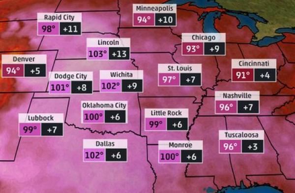
Stoddard County, Missouri - A dome of high pressure will expand across the nation next week. Hot temperatures and dangerous heat indices will be expected.
Beginning Sunday, July 27, 2016 the temperatures will be in the mid to upper 90s with heat index over 100 degrees. Lows will only drop to the mid to upper 70s with humidity just under 70%.
Since June, many regions of the U.S. have experienced periods of hot temperatures, but most heat waves have been relatively short-lived. That will all change next week as a dome of high pressure builds in the upper atmosphere, providing favorable conditions for expanding heat across much of the nation.
By Thursday, summer heat will be the dominant weather theme as temperatures really soar. We are going to be sweating next week, no way to get around it SUMMER is here! Don't be surprised if there will be Heat Advisory Statements issued by the National Weather Service. Also remember to check on elderly or those without air conditioning. Pets should have plenty of shade and water throughout the day and if on concrete remember it gets very hot on their foot pads.

