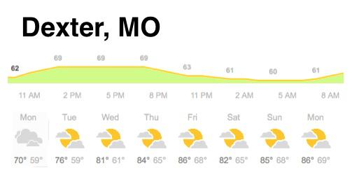
Dexter, Missouri - Weekly weather for Monday, June 1st - Sunday June 7th.
Monday Cloudy, with a high near 73.
Monday evening Mostly cloudy, with a low around 58.
Tuesday Mostly sunny, with a high near 77.
Tuesday Night Partly cloudy, with a low around 59.
Wednesday Mostly sunny, with a high near 82.
Wednesday Night Partly cloudy, with a low around 64.
Thursday Mostly sunny, with a high near 84.
Thursday Night A slight chance of showers and thunderstorms. Partly cloudy, with a low around 66.
Friday A chance of showers and thunderstorms. Mostly sunny, with a high near 85.
Saturday Partly cloudy with a slight chance of thunderstorms. High 84F. Winds SSE at 5 to 10 mph. Chance of rain 30%
Sunday Mixed clouds and sun with scattered thunderstorms. High 84F. Winds SE at 5 mph 10 mph. Chance of rain 40%.
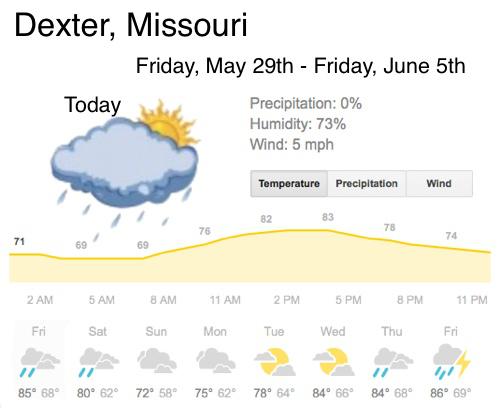
Friday A 50% chance of showers and thunderstorms after 1pm. Partly sunny, with a high near 85.
Friday Night A 40 percent chance of showers and thunderstorms. Mostly cloudy, with a low around 69.
Saturday Showers and thunderstorms likely. Mostly cloudy, with a high near 83. Chance of precipitation is 60%.
Saturday Night A chance of showers and thunderstorms. Mostly cloudy, with a low around 61.
Sunday A chance of showers and thunderstorms. Mostly cloudy, with a high near 73.
Sunday Night A slight chance of showers and thunderstorms. Mostly cloudy, with a low around 61.
Monday Cloudy with a high 77 and a low of 62.
Tuesday Partly sunny with a high of 80 and a low of 65.
Wednesday Partly sunny with a high of 85 and a low of 69.Thursday Partly cloudy early with thunderstorms becoming likely during the afternoon. High around 85F. Winds SSE at 5 to 10 mph. Chance of rain 80%
Friday Thunderstorms likely in the morning. Then the chance of scattered thunderstorms in the afternoon. High 86F. Winds light and variable. Chance of rain 80%
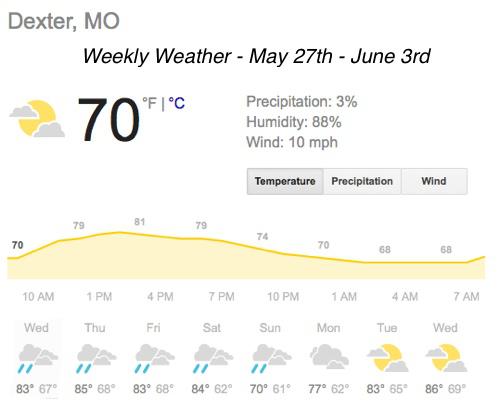
Dexter, Missouri - Weekly weather for Wednesday, May 27th - Wednesday, June 3rd.
Today A 30 percent chance of showers and thunderstorms. Partly sunny, with a high near 82.
Tonight A 30 percent chance of showers and thunderstorms, mainly before 1am. Mostly cloudy, with a low around 67.
Thursday A 20 percent chance of showers and thunderstorms before 1pm. Partly sunny, with a high near 84.
Thursday Night Mostly cloudy, with a low around 68.
Friday A 40 percent chance of showers and thunderstorms after 1pm. Partly sunny, with a high near 85.
Friday Night A 20 percent chance of showers and thunderstorms. Mostly cloudy, with a low around 69.
Saturday Showers and thunderstorms likely. Mostly cloudy, with a high near 83. Chance of precipitation is 60%.
Saturday Night A chance of showers and thunderstorms. Mostly cloudy, with a low around 61.
Sunday A chance of showers and thunderstorms. Mostly cloudy, with a high near 73.
Sunday Night A slight chance of showers and thunderstorms. Mostly cloudy, with a low around 61.
Monday Cloudy with a high 77 and a low of 62.
Tuesday Partly sunny with a high of 83 and a low of 65.
Wednesday Partly sunny with a high of 86 and a low of 69.
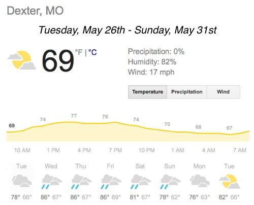
Dexter, Missouri - Weekly weather for Tuesday, May 26th - Sunday, May 31st.
Today A 40 percent chance of showers and thunderstorms. Mostly cloudy, with a high near 81.
Tonight A 20 percent chance of showers and thunderstorms. Mostly cloudy, with a low around 67.
Tomorrow A 30 percent chance of showers and thunderstorms, mainly after 1pm. Mostly cloudy, with a high near 83.
Tomorrow Night A 30 percent chance of showers and thunderstorms. Mostly cloudy, with a low around 67.
Thursday A 20 percent chance of showers and thunderstorms. Partly sunny, with a high near 86.
Thursday Night A 10 percent chance of showers and thunderstorms. Mostly cloudy, with a low around 69.
Friday A 30 percent chance of showers and thunderstorms. Partly sunny, with a high near 84.
Friday Night A slight chance of showers and thunderstorms. Mostly cloudy, with a low around 69.
Saturday A chance of showers and thunderstorms. Mostly cloudy, with a high near 83.
- ... SIGNIFICANT WEATHER ADVISORY FOR RIPLEY... WAYNE... CARTER... BOLLINGER... STODDARD AND BUTLER COUNTIES UNTIL 845 PM CDT...
- AT 711 PM CDT... DOPPLER RADAR WAS TRACKING STRONG THUNDERSTORMS OVER NORTHEAST ARKANSAS... AROUND POCAHONTAS... MOVING NORTHEAST AT 40 MPH.
- HALF INCH HAIL AND GUSTY WINDS TO 45 MPH WILL BE POSSIBLE WITH SOME OF THESE STORMS.
- LOCATIONS IMPACTED INCLUDE... POPLAR BLUFF... DEXTER... DONIPHAN... PIEDMONT... BERNIE... BLOOMFIELD... MARBLE HILL... ADVANCE... VAN BUREN... GREENVILLE... SAM A BAKER STATE PARK... WAPPAPELLO LAKE AREA... MOREHOUSE... PUXICO... NAYLOR... NEELYVILLE... ESSEX... QULIN... BELL CITY AND ELLSINORE.
- A TORNADO WATCH REMAINS IN EFFECT UNTIL 1000 PM CDT FOR SOUTHEASTERN MISSOURI.

- THE NATIONAL WEATHER SERVICE HAS ISSUED TORNADO WATCH 205 IN EFFECT UNTIL 10 PM CDT THIS EVENING FOR THE FOLLOWING AREAS
- IN ILLINOIS THIS WATCH INCLUDES 5 COUNTIES
- IN SOUTHERN ILLINOIS
- ALEXANDER JACKSON PERRY PULASKI UNION
- IN KENTUCKY THIS WATCH INCLUDES 4 COUNTIES
- IN WESTERN KENTUCKY
- BALLARD CARLISLE FULTON HICKMAN
- IN MISSOURI THIS WATCH INCLUDES 11 COUNTIES
- IN SOUTHEAST MISSOURI
- BOLLINGER BUTLER CAPE GIRARDEAU CARTER MISSISSIPPI NEW MADRID PERRY RIPLEY SCOTT STODDARD WAYNE
- THIS INCLUDES THE CITIES OF... BARDWELL... BLOOMFIELD... CAIRO... CAPE GIRARDEAU... CARBONDALE... CHARLESTON... CLINTON... DONIPHAN... HICKMAN... JONESBORO... MARBLE HILL... MOUND CITY... NEW MADRID... PERRYVILLE... PIEDMONT... PINCKNEYVILLE... POPLAR BLUFF... SIKESTON... VAN BUREN AND WICKLIFFE.

- THE NATIONAL WEATHER SERVICE HAS ISSUED TORNADO WATCH 112 IN EFFECT UNTIL 8 PM CDT THIS EVENING FOR THE FOLLOWING AREAS
- IN ILLINOIS THIS WATCH INCLUDES 19 COUNTIES
- IN SOUTHERN ILLINOIS
- ALEXANDER EDWARDS FRANKLIN GALLATIN HAMILTON HARDIN JACKSON JEFFERSON JOHNSON MASSAC PERRY POPE PULASKI SALINE UNION WABASH WAYNE WHITE WILLIAMSON
- IN INDIANA THIS WATCH INCLUDES 6 COUNTIES
- IN SOUTHWEST INDIANA
- GIBSON PIKE POSEY SPENCER VANDERBURGH WARRICK
- IN KENTUCKY THIS WATCH INCLUDES 22 COUNTIES
- IN WESTERN KENTUCKY
- BALLARD CALDWELL CALLOWAY CARLISLE CHRISTIAN CRITTENDEN DAVIESS FULTON GRAVES HENDERSON HICKMAN HOPKINS LIVINGSTON LYON MARSHALL MCCRACKEN MCLEAN MUHLENBERG TODD TRIGG UNION WEBSTER
- IN MISSOURI THIS WATCH INCLUDES 7 COUNTIES
- IN SOUTHEAST MISSOURI
- BOLLINGER CAPE GIRARDEAU MISSISSIPPI NEW MADRID PERRY SCOTT STODDARD
- THIS INCLUDES THE CITIES OF... ALBION... BARDWELL... BENTON... BLOOMFIELD... BOONVILLE... CADIZ... CAIRO... CALHOUN... CAPE GIRARDEAU... CARBONDALE... CARMI... CHARLESTON... CLINTON... DIXON... EDDYVILLE... ELIZABETHTOWN... ELKTON... EVANSVILLE... FAIRFIELD... FORT BRANCH... GOLCONDA... GREENVILLE... HARRISBURG... HENDERSON... HERRIN... HICKMAN... HOPKINSVILLE... JONESBORO... MADISONVILLE... MARBLE HILL... MARION... MAYFIELD... MCLEANSBORO... METROPOLIS... MORGANFIELD... MOUND CITY... MOUNT CARMEL... MOUNT VERNON... MURRAY... NEW MADRID... OWENSBORO... PADUCAH... PERRYVILLE... PETERSBURG... PINCKNEYVILLE... POSEYVILLE... PRINCETON... ROCKPORT... SHAWNEETOWN... SIKESTON... SMITHLAND... VIENNA... WEST FRANKFORT AND WICKLIFFE.

