Dee Loflin, SMT Manager/Editor
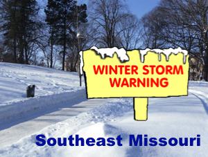
A WINTER STORM WARNING REMAINS IN EFFECT FROM 3 PM THURSDAY TO 6 PM CST FRIDAY.
* TIMING... FREEZING RAIN AND SLEET WILL OVERSPREAD THE AREA THURSDAY AFTERNOON... WITH THE PRECIPITATION TRANSITIONING TO SLEET AND SNOW QUICKLY THURSDAY NIGHT BEFORE WINDING DOWN FRIDAY AFTERNOON.
* AMOUNTS... 5 TO 7 INCHES OF SLEET AND SNOW ARE EXPECTED... WITH SOME VERY MINOR ICING POSSIBLE BENEATH IT.
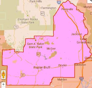
* MAIN IMPACTS... TREACHEROUS DRIVING CONDITIONS ARE LIKELY FROM THURSDAY AFTERNOON THROUGH FRIDAY. IN ADDITION... SOME ISOLATED POWER OUTAGES CANNOT BE RULED OUT... WHERE FREEZING RAIN IS MOST PREVALENT... MAINLY ACROSS THE SOUTHERN PORTIONS OF SOUTHEAST MISSOURI.
PRECAUTIONARY/PREPAREDNESS ACTIONS...
A WINTER STORM WARNING MEANS SIGNIFICANT AMOUNTS OF SNOW... SLEET... AND ICE ARE EXPECTED OR OCCURRING. STRONG WINDS ARE ALSO POSSIBLE. THIS WILL MAKE TRAVEL VERY HAZARDOUS OR IMPOSSIBLE. IF YOU MUST TRAVEL... KEEP AN EXTRA FLASHLIGHT... FOOD... AND WATER IN YOUR VEHICLE IN CASE OF AN EMERGENCY.
Submitted by
Dee Loflin, SMT Manager/Editor
Southeast Missouri - An Arctic cold front will move through the area tonight. A pair of disturbances will move northeast across the area beginning Thursday afternoon and continuing through the day Friday. As temperatures drop below freezing, a wintry mix of precipitation is expected across the entire region.
Winter Storm Warning remains in effect from 3 pm Thursday to 6 pm CST Friday.
A Winter Storm Warning remains in effect from 3 pm Thursday to 6 pm CST Friday.
- Timing: Freezing rain and sleet will overspread the area Thursday afternoon, with the precipitation transitioning to sleet and snow quickly Thursday night before winding down Friday afternoon.
- Amounts, 5 to 7 inches of sleet and snow are expected, with some very minor icing possible beneath it.
- Main impacts: treacherous driving conditions are likely from Thursday afternoon through Friday. In addition. Some isolated power outages cannot be ruled out, where freezing rain is most prevalent, mainly across the southern portions of southeast Missouri.

Dee Loflin, SMT Manager/Editor
The Missouri Department of Transportation is carefully monitoring weather forecasts and preparing to plow and treat state routes as needed. Travelers should also take their own precautions, as the first bout of snow or ice means motorists' winter driving skills may be a bit rusty.
Remember that even light precipitation can cause roads to become slick with ice or snow. While MoDOT works hard to treat and plow Missouri highways when winter weather hits, it's important to allow extra time for travel and to check road conditions before you head out. Remember the following tips when driving in inclement weather:
* Slow down
* Steer and brake gently
* Accelerate slowly at intersections
* Allow extra space between your vehicle and the one ahead of you
* Stay back 100 feet from snow plows that may be spreading salt
* Avoid passing snow plows, even when on a multi-lane road
* Be aware that bridges and overpasses generally experience
freezing conditions first
One of the best ways to prepare for winter travel is to check road conditions before you go. MoDOT's Traveler Information Map, at www.modot.org, provides current road conditions for Missouri's interstates and major highways. Conditions for these routes are color coded to give you the information you need at a glance.
For smartphone and tablet users, the Traveler Information App brings the same information to mobile devices. The app is available for free from the iPhone and Android app stores by searching for "MoDOT."
MoDOT also provides road conditions information through our Customer Service Center. Dial 888-ASK-MODOT (888-275-6636) to speak to one of our expert customer service representatives. They are available 24 hours a day, 365 days a year.
Dee Loflin, SMT Manager/Editor
Stoddard County, Missouri - The National Weather Service in Paducah Kentucky has issued a Winter Storm Watch for the Quad State Region for Thursday Night and Friday. Travel across the area during that time will be hazardous at times.
Click on the following link to learn more about the timing and impacts of the upcoming Winter Storm on your area.
Click HERE for the National Weather Service website.
Submitted by
Dee Loflin, SMT Manager/Editor
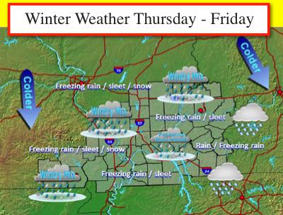
Stoddard County, Missouri - .......... WINTER WEATHER IMPACTS LIKELY THURSDAY NIGHT THROUGH FRIDAY...
ARCTIC AIR WILL SPREAD ACROSS THE REGION THURSDAY THROUGH FRIDAY IN THE WAKE OF A STRONG COLD FRONTAL PASSAGE WEDNESDAY NIGHT. MEANWHILE STRONG FLOW IN THE UPPER LEVELS OF THE ATMOSPHERE WILL CARRY DISTURBANCES FROM SOUTHWEST TO NORTHEAST ACROSS THE REGION. THE DISTURBANCES WILL GENERATE WINTRY PRECIPITATION IN THE COLD ARCTIC AIR.
THE PRECIPITATION SHOULD FIRST DEVELOP OVER SOUTHEAST MISSOURI INTO SOUTHERN ILLINOIS THURSDAY EVENING... THEN TOWARD THE OHIO RIVER AND POSSIBLY INTO FAR WEST KENTUCKY AND SOUTHWEST INDIANA LATER THURSDAY NIGHT. FREEZING RAIN AND SLEET APPEAR MOST LIKELY INITIALLY... POSSIBLY MIXING WITH SNOW BY FRIDAY MORNING OVER SOUTHERN ILLINOIS AND SOUTHEAST MISSOURI.
THE TRANSITION TO FREEZING RAIN... SLEET... AND POSSIBLY SOME SNOW... WILL CONTINUE TO EXPAND EAST FRIDAY OVER THE REMAINDER OF WEST KENTUCKY AND SOUTHWEST INDIANA AS ANOTHER WAVE OF PRECIPITATION MOVES ACROSS THE REGION. HIGHEST PRECIPITATION AMOUNTS FRIDAY SHOULD BE ALONG AND SOUTH AND EAST OF THE OHIO RIVER.
THIS IS A COMPLEX FORECAST WITH MANY VARIABLES IN PLAY. IT IS STILL TOO SOON TO FORECAST SPECIFIC AMOUNTS OF SNOW AND ICE AT THIS TIME. HOWEVER... GIVEN THE AMOUNT OF PRECIPITATION THAT IS BEING FORECAST IN OUR MODEL DATA... THE POTENTIAL DOES EXIST FOR MODERATE ACCUMULATIONS OF ICE OR SLEET... AND SOME SNOW... THAT COULD HAVE CONSIDERABLE IMPACTS ACROSS PORTIONS OF THE AREA.
For the latest click HERE.

