Local News
Local Churches Cancel Wednesday Events
May 25th 2011 by News
Due to severe weather forcasted for our region for Wednesday evening at soe area churches have reported cancellations to the ShowMe Times.
The ShowMe Times has been informed of the following cancellations:
- All functions at the First Baptist Church in Dexter
- The Chancel Choir at the First United Methodist Church in Dexter is cancelled. Choir Director MaryRuth Boone said "stay home and stay safe."
- The 6:30 Hope Epidemic Chapel service at the Sikeston First United Methodist Church
- All activities at the Risen Church (2nd General Church) in Dexter have been cancelled Wednesday evening.
- The Ecumenical Prayer Service at 6 p.m. this evening at the First Christian Church (Disciples of Christ) in Dexter has been postponed.
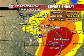
A major severe weather outbreak is expected across the region today and this evening. Storms are expected to quickly develop into supercells over southeast Missouri and southwest Illinois early this afternoon. These storms will move northeast across the area at 35 to 45 MPH. Individuals in the area should be on the alert all day Wednesday for severe weather and take necessary shelter if necessary.
Churches and organizations cancelling activities may send information to the ShowMe Times and information be updated.Please send information to amiller@showmetimes.com
Last Updated on May 25th 2011 by News
https://showmetimes.com/Blogpost/uiq3/Local-Churches-Cancel-Wednesday-Events
WEATHER STATUS BRIEFING: Noon 05252011
May 25th 2011 by Staff Writer
A STORM SHELTER HAVE BEEN OPENED IN THE FOLLOWING AREAS:
1. DEXTER AT THE FIRST BAPTIST
2. BLOOMFIELD CITY HALL
3. ADVANCE 1ST BAPTIST CHURCH
4. PUXICO LIFE CHAPEL ASSEMBLY
5. BERNIE COMMUNITY CENTER
6. DUDLEY—RICHLAND GRAIN
KDEX IS UPDATING THE PUBLIC OF THE SITUATION.
----------------------------------------------------------------------
A major severe weather outbreak is expected across the Quad State region today and this evening. Storms are expected to quickly develop into supercells over southeast Missouri and southwest Illinois late this morning or early this afternoon. These storms will move northeast across the area at 35 to 45 MPH.
More development will be possible farther east across the region later this afternoon. Any storm will be capable of producing strong long track tornadoes, very large hail 2" or greater in diameter, and damaging straight-line winds. Everyone is encouraged to keep abreast of the weather today and know where to take safe shelter no matter where they are today.
A final broken line of severe storms along a dry line will enter southeast Missouri around 5 PM. This line of storms will move east across the area through the evening. All severe weather should be east of the area by Midnight.
Last Updated on May 25th 2011 by Staff Writer
https://showmetimes.com/Blogpost/uiq2/WEATHER-STATUS-BRIEFING--Noon-05252011
WEATHER STATUS BRIEFING: From SCAD
May 25th 2011 by Staff Writer
A major severe weather outbreak is expected across the Quad State region today and this evening. Storms are expected to quickly develop into supercells over southeast Missouri and southwest Illinois late this morning or early this afternoon. These storms will move northeast across the area at 35 to 45 MPH.
More development will be possible farther east across the region later this afternoon. Any storm will be capable of producing strong long track tornadoes, very large hail 2" or greater in diameter, and damaging straight-line winds.
Everyone is encouraged to keep abreast of the weather today and know where to take safe shelter no matter where they are today. A final broken line of severe storms along a dry line will enter southeast Missouri around 5 PM.
This line of storms will move east across the area through the evening. All severe weather should be east of the area by Midnight.
HAZARDOUS WEATHER OUTLOOK
NATIONAL WEATHER SERVICE PADUCAH KY
813 AM CDT WED MAY 25 2011
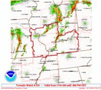
COUNTIES EFFECTED: JEFFERSON-WAYNE IL-EDWARDS-WABASH-PERRY IL-FRANKLIN-HAMILTON- WHITE-JACKSON-WILLIAMSON-SALINE-GALLATIN-UNION IL-JOHNSON-POPE- HARDIN-ALEXANDER-PULASKI-MASSAC-GIBSON-PIKE-POSEY-VANDERBURGH- WARRICK-SPENCER-FULTON-HICKMAN-CARLISLE-BALLARD-MCCRACKEN-GRAVES- LIVINGSTON-MARSHALL-CALLOWAY-CRITTENDEN-LYON-TRIGG-CALDWELL- UNION KY-WEBSTER-HOPKINS-CHRISTIAN-HENDERSON-DAVIESS-MCLEAN- MUHLENBERG-TODD-PERRY MO-BOLLINGER-CAPE GIRARDEAU-WAYNE MO-CARTER- RIPLEY-BUTLER-STODDARD-SCOTT-MISSISSIPPI-NEW MADRID- 813 AM CDT WED MAY 25 2011
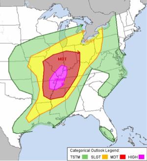
...AREA UPGRADED TO HIGH RISK...
...WIDESPREAD SEVERE THUNDERSTORMS EXPECTED THIS AFTERNOON AND EVENING...THIS HAZARDOUS WEATHER OUTLOOK IS FOR PORTIONS OF SOUTHERN ILLINOIS...SOUTHWEST INDIANA...WESTERN KENTUCKY AND SOUTHEAST MISSOURI.
WEDNESDAY, MAY 25, 2011 ...TODAY AND TONIGHT
THE ENTIRE QUAD STATE AREA IS IN A HIGH RISK OF SEVERE WEATHER TODAY AND TONIGHT. THIS IS A PARTICULARLY DANGEROUS SITUATION...AS THE POTENTIAL EXISTS FOR A SIGNIFICANT AND WIDESPREAD SEVERE WEATHER EVENT ACROSS THE REGION. SOME LOCATIONS MAY EXPERIENCE 2 OR 3 SEPARATE ROUNDS OF SEVERE WEATHER THROUGH THIS EVENING.
SCATTERED THUNDERSTORMS WILL DEVELOP OVER SOUTHEAST MISSOURI AND SOUTHERN ILLINOIS...POSSIBLY AS EARLY AS THE LATE MORNING HOURS. VERY STRONG WIND FIELDS AND PLENTIFUL INSTABILITY WILL ALLOW THE STORMS TO QUICKLY BECOME SEVERE...WITH LARGE HAIL...STRONG TORNADOES...AND DAMAGING WINDS. THE STORMS WILL MOVE RAPIDLY NORTHEAST ACROSS THE QUAD STATE REGION THROUGH THE AFTERNOON. OTHER SEVERE THUNDERSTORMS MAY DEVELOP FARTHER EAST ACROSS THE AREA DURING THE AFTERNOON.
FINALLY...A LINE OF SEVERE STORMS WITH AN INCREASING DAMAGING WIND THREAT WILL MOVE INTO WESTERN PORTIONS OF THE AREA AROUND 5 PM...AND THEN SWEEP THROUGH THE ENTIRE AREA THROUGH THE EVENING. TORNADOES...LARGE HAIL...AND HEAVY RAINFALL WILL ALSO BE POSSIBLE WITH THIS LINE. THE SEVERE WEATHER THREAT SHOULD BE EAST OF THE ENTIRE AREA BY MIDNIGHT.
OUTSIDE OF THUNDERSTORMS...STRONG SOUTH WINDS ARE EXPECTED TO GUST 25 TO 35 MPH THROUGH THE DAY AND INTO THE EARLY EVENING. CONSULT THE LAKE WIND ADVISORY FOR DETAILS.
MAY 26 THROUGH MAY 31: DAYS TWO THROUGH SEVEN...THURSDAY THROUGH TUESDAY
A FEW THUNDERSTORMS WILL BE POSSIBLE AS AN UPPER LEVEL LOW PRESSURE SYSTEM MOVES EAST THROUGH THE REGION THURSDAY. ANY THUNDERSTORMS ARE EXPECTED TO REMAIN BELOW SEVERE LIMITS.
ANOTHER UPPER LEVEL STORM SYSTEM WILL SWEEP THROUGH THE AREA WITH A CHANCE OF THUNDERSTORMS FRIDAY NIGHT. AT THIS TIME...SEVERE WEATHER IS NOT EXPECTED.
Last Updated on May 25th 2011 by Staff Writer
https://showmetimes.com/Blogpost/uipt/WEATHER-STATUS-BRIEFING--From-SCAD
Lake Ready For Summer; T Bypass Open
May 25th 2011 by News
By Annabeth Miller ,
ShowMe Times Editor
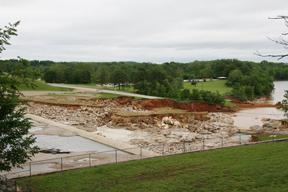
The U.S. Army Corps of Engineers held a set of three community meetings around Wappapello on Tuesday to update residents on the status of work and to allow them to ask questions and voice concerns.
The biggest news of the day was delivered by Lindell Huskey with the Missouri Deprtment of Transportation – welcome news for those who live, work and visit the lake area.
“The T Highway bypass will be completed this evening,”Huskey said to the applause of the large crowd at Crabb’s Fisherman’s Net restaurant Tuesday afternoon. “In fact, the folks who come to the meeting this evening (the second Corps meeting) should be able to go home on the new road.”
Officials with the Corps, the Missouri Department of Transportation, and a representative of State Sen. Rob Mayer’s office , Brad Jarrell, were all in attendance at the earl afternoon gathering.
The new road was built in less than two weeks, and is located along the Southside Spillway Access Road, which runs through the Blue Hole area. The roadway will be used until a decision is made about rebuilding the section of T Highway that was destroyed when the water overtook the spillway.
Wappapello Lake Operations Manager Cindy Jackson said the Corps of Engineers will work with the Missouri Department of Transportation and federal and state officials to develop ideas for how Highway T roadway will be rebuilt.
Open For Summer
This coming weekend is the traditional start of the summer season at Wappapello, and Jackson wants folks to realize that the lake is still “open”.
“I will open the campground at Redman on Thursday morning, and the upper campground at People’s Creek is already open,” she said. The Bill Emerson Visitor Center has reopened
A new road leading to the Redman Creek boat ramp is being constructed and should be open by Memorial Day weekend, Jackson said. The road will lead down the hillside from the Bill Emerson Visitor Center to the Redman launch area. The road will be gravel for now, until arrangements can be made for asphalting.
“The lake level is dropping 8 to 10 inches a day, she said, and as the water drops repairs and cleanup at recreational areas will begin. She stressed, however that visitors are indeed welcome during the upcoming holiday weekend. She said businesses have been readying for the holiday weekend and the summer season.
“I think this (the high water) has probably helped the crappie spawn,” Jackson said. “Nature takes care of things.”
“We’ve had floods before and we’ve done cleanup before – we’ll be business as usual with that,” she said. “I’ve got a resourceful staff.”
Summer pool at the lake is anticipated by early July at Wappapello.
Lake Wappapello
Lake Hotline
Last Updated on May 25th 2011 by News
https://showmetimes.com/Blogpost/uips/Lake-Ready-For-Summer-T-Bypass-Open
Huckabee Praises TRC Graduates
May 23rd 2011 by News

A SMT News Report
POPLAR BLUFF, M0. – The men and women who graduated from Three Rivers College on Sunday afternoon received praise for their tenacity and determination in completing a degree at the region’s community college.
Former Arkansas Gov. Mike Huckabee was the guest speaker at Sunday’s commencement, held in front of a crowd of more than 1,200 people at the Black River Coliseum.
“You know this was the path to a better job and a better future,” Huckabee told the graduates. Until last week, Huckabee was considered one of the leading contenders for the GOP nomination for president in 2012. "Your presence on this stage, receiving this diploma in an indication you are capable of doing what you wanted to do. Keep doing it.”
Huckabee praised Three Rivers and America’s community colleges in his Poplar Bluff address.
“The real builder of the workforce in America’s future is in community college,” Huckabee said. The former presidential candidate said that community colleges have the ability to meet changing needs of a workforce.
Friend and U.S. Rep. Jo Ann Emerson introduced Huckabee at the commencement ceremony. Emerson said Huckabee “understands our way of life” and appreciates the work ethic represented in the Three Rivers graduates.

Photos Above: Former Arkansas governor Mike Huckabee was the guest speaker at commencement at Three Rivers College on Sunday afternoon. Huckabee shared the stage with U.S. Rep. Jo Ann Emerson and TRC President Dr. Devin Stephenson (top photo). Huckabee (bottom photo) praised the college graduates for their hard work and dedication. (ShowMe Times photos by Andrew Cato)
Last Updated on May 23rd 2011 by Unknown
https://showmetimes.com/Blogpost/uiph/Huckabee-Praises-TRC-Graduates

