Local News
Corps: Goal Is To Not Execute Plan
April 29th 2011 by News
By Annabeth Miller,
ShowMe Times Editor
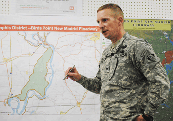
SIKESTON, Mo. - Fighting floods in 2011 is an art coupled with science, according to the commander of the U.S. Army Corps of Engineers in charge of directing efforts on the Mississippi River.
Col. Vernie L. Reichling, commander of the U.S. Army Corps of Engineers Memphis District, said the corps top priority is public safety as the floodfighting on the river is coming down to a matter of inches and cooperation from Mother Nature.
Reichling spoke Thursday afternoon at the corps information center in Sikeston. He explained that floodfighting in 2011 is taking a “systems-wide” approach – what one part of the river does affects the whole. “’Hold as much as you can.’ That is our message to our brothers north and east of us,” Reichling said. He explained the corps is holding back as much water as possible in Lakes Barkley and Kentucky, reducing the waters flowing into the Ohio and into the Mississippi. “This is a system approach to try to prevent not only the operation of the (Birds Point New Madrid) floodway, but reducing the risk of flooding all over.”
“We are not out of the woods yet,” he said. As of Thursday, Reichling reported the corps had a large contingent in the region fighting the flood.
“We have plenty of boots on the ground,” he said. There are currently 200 men and women in the field and the corps has spend $3.3 million in fighting the flood since it activated on Sunday, April 24.
Reichling is the officer in charge of the corps operation in the floodway, but he reports to Maj. Gen. Michael Walsh, president of the Mississippi River Commission. It is the commission that will issue any order to activate the floodway in Southeast Missouri.
Reichling and his staff said the corps was doing everything possible to avoid activating the floodway – accomplished by blowing holes in the Birds Point levee. However, the stage is set if such an action is ordered. The MV Mississippi, a corps motor vessel is currently at Hickman, Kent., with two barges carrying the munitions that would be used to blow three holes in the floodway levee – one at the northern end and two south. But this action would submerge over 130,000 acres of prime agriculture land, destroy homes and the livelihood of a region.
The corps has completed the ground preparations at two of the three sites on the levee system, and the third expected to be completed by the end of Thursday. But the munitions will remain downriver and no further action will be taken until – or if – the order is given to activate the floodway.
“We are listening to the river ,” Reichling said “This is not a science – it is an art. We are taking a holistic approach and reacting to the stresses on the system. We are constantly evaluation conditions,” he said. “Our goal is to not execute the floodway.”
Photo Above: Col. Vernie L. Reichling, Commander of the U.S. Army Corps of Engineers Memphis District, points out features of the Birds Point New Madrid Floodway during a briefing.
Last Updated on April 29th 2011 by News
https://showmetimes.com/Blogpost/uik0/Corps-Goal-Is-To-Not-Execute-Plan
Highway 60 Reopened Dexter To Sikeston
April 29th 2011 by News

By Annabeth Miller
[ShowMe Times Editor
U.S. Highway 60 between Sikeston and Dexter was closed at late Thursday afternoon as the Missouri Department of Transportation fought flooding across the roadway near Morehouse.
By 4:30 p.m. Thursday westbound traffic leaving Sikeston was delayed in two lane, bumper-to-bumper traffic that inched its way toward Morehouse. Once to Morehouse, traffic was turned as drivers returned to Sikeston and forced to find alternative routes.
Much westbound traffic toward Dexter was re-routed to I-55 to Portageville, and then Highway 62 to Malden where drivers were able to turn north onto Highway 25.
By 6:30 a.m. Friday, Highway 60 was re-opened to traffic. Motorists can expect two-lane traffic on the eastbound lanes from Route E to Route AH.
Motorists are urged to use extreme caution near the area.
Photo Above: An ariel photo of the Highway 60 at Morehouse, taken Thursday afternoon by the New Madrid County Sheriff's Department.
Last Updated on April 29th 2011 by News
https://showmetimes.com/Blogpost/uijv/Highway-60-Reopened-Dexter-To-Sikeston
Dexter Prepares To Honor Veterans
April 28th 2011 by News

By Annabeth Miller,
ShowMe Times Editor
The flags are being being unfurled and last minute preparations completed as Dexter citizens prepare to honor on Friday members of "the greatest generation" - veterans of World War II.
The Honor Tour organization will gather Friday morning and depart on another tour of Washington, D.C. with 30 veterans of World War II. The departure ceremony honoring these veterans and their colleagues will be held at 8:30 a.m., Friday, at the Bearcat Event Center on Grant Street in Dexter."
Three Dexter men are a part of this Honor Tour journey - Chet Medler, Joe Hutchason and Russell Orville. A total of 30 men from Missouri, Illinois, Kansas, and California will make the journey.
The 30 men on the tour will be recognized prior to their official departure on the tour. The tour is sponsored by the Honor Tour group and coordinated by Rob Callahan.
Students from all four Dexter schools will be attending the departure ceremony, with several high school students - including the Honors Choir and Jazz Band - participating.
"My hope is that the community will come and be a part of this ceremony,” said Dr. Roger Alsup, principal at Dexter’s T.S. Hill Middle School. He has chaired the community planning committee for Friday’s event.
A number of special displays will be featured both outside the BEC and inside for the public to view.
The bus with the veterans will leave Poplar Bluff early Friday morning and will arrive in Dexter by 7:30 a.m. The motorcade will enter the city at the Route AD exit off Highway 60, and will follow Business 60 to One Mile Road and the BEC. City crews will line the route with American flags.
Following the departure from the BEC, the motorcade will travel east on Grant Street to Catalpa, and then turn east onto Stoddard Street.
Event organizers encourage groups, businesses and individuals unable to attend the ceremony to line Stoddard Street from Catalpa to the Dexter City Administration Building as a tribute to the veterans. Boy Scout Troop 200 will post the American flags along the part of the motorcade, and individuals on the route are encouraged to have flags.
When: Friday, April 29
Time: 8:30 a.m.
Where: Bearcat Event Center on Grant Street
Last Updated on April 28th 2011 by News
https://showmetimes.com/Blogpost/uijs/Dexter-Prepares-To-Honor-Veterans
MoDOT Closes Area Roadways
April 27th 2011 by News

A SMT News Report
Flooded Roads in Southeast Missouri Update 6:00 a.m. SIKESTON - The Missouri Department of Transportation announced at 6 a.m. today the list of roadways in Southeast Missouri closed due to the recent flooding. Motorists are urged to use extreme caution and plan alternate routes.
Routes that are closed include:
Stoddard County
•· Route 51 - from Puxico to Route C (Bollinger County)
•· Route 60 - WB traffic diverted to EB lanes from CRD 785 to Route N
•· Route 91 - Diversion Channel to Route T
•· Route 91 - Route P to the Scott County line •· Route AB - beginning at 1 mile before Route N and ending at Route N
•· Route BB
•· Route D - from CRD 751 to CRD 725
•· Route E - Route FF/E Intersection to Route N/E at Circle City
•· Route K - from Route 51 to Route 25
•· Route M - from Leora and Route K
•· Route MM - from Route U in Stoddard County to County Road 102 in Dunklin County
•· Route N - from Route AB to Route 60
•· Route O - from Route P to CRD 309
•· Route P - Route O to Route 25
•· Route T - from Route 51 to the intersection of Routes T and J
•· Route V - Sturdivant
•· Route Y - from Route AB to Route Z
•· Route Z - from Route VV to West City Limits of Bernie
Bollinger County
•· Route 51 - from Route C to Puxico (Stoddard County)
•· Route 91 - Diversion Channel to Route T
•· Route H - from Route 51 to Route 142
•· Route N - Route F to Route 25
•· Route V - Sturdivant
•· Route W - Route 51 to the end of state maintenance
Butler County
•· Route 53 - from Route J to Route 67
•· Route 142 - from Route 67 to Route W (Ripley County)
•· Route 142 - from Route 158 ending 1 mile before Route 67
•· Route 158 - from Route BB to Route 142
•· Route AA - from Route 51 to Route B
•· Route B - at Route 51 and ending 2 miles after Route AA
•· Route BB - beginning 4 miles before Route 158 and ending at 158
•· Route CC - from Route 53 to Route U
•· Route EE
•· Route FF - from Route CC to Route 51
•· Route H
•· Route HH
•· Route N - near Oglesville from Route 53 to Route 51
•· Route OO - from Route FF to end of state maintenance
•· Route T - from Route D to CRD 517
•· Route W - from Route O to 1 mile from US67
Cape Girardeau County
•· MO 25 - closed from Route K to Route 77
•· Route 74 - from Route 25 to I-55
•· Route 177 - from CRD 657 to Cape Rock Drive
•· Route A - from Route U to Route F
•· Route N - Intersection of N, U and T to Route F
•· Route N - Allenville Spur to Route F (Bollinger County)
•· Route RA - from Route U to the end of state maintenance
•· Route T - Intersection of N, U and T to Route F
•· Route U - from Route N to Route A
Dunklin County
•· Route DD - from Route 53 to the end of state maintenance
•· Route MM - from CRD 102 to Route U (Stoddard County)
•· Route UU - from CRD 729 to the end of state maintenance
Mississippi County
•· Route 62 - City of Bertrand
•· Route 77 - at the Mississippi River
•· Route 77 - from Route D to Route A
•· Route 80 - from the Mississippi River to Belmont
•· Route 102 - from Route 105 to Route 77
•· Route 102 - from the levee to CRD 526
•· Route A - from Route 102 to Route 77
•· Route AA - from Route 80 to Route 77
•· Route F - beginning Route 77
•· Route FF
•· Route J - from US 60 to Route AB
•· Route NN - intersection of Routes NN and 62
•· Route OO - from Route BB to CRD 525
•· Route Y - from Route 60 to Route K
•· Route YY
New Madrid County
•· Route 80 West - from I-55 to Route H
•· Route 153 - 1 mile after Route EE to Gideon City limits
•· Route 162 - at the Mississippi River
•· Route H - from Route E to Route FF
•· Route M - from Route F to Route 162
•· Route MM - from Route D to CRD 621
•· Route P - from I-55 to Route BB
•· Route V - from Route P to Route 80
•· Route W - from CRD 621 to CRD 623
•· Route WW
Pemiscot County
•· Route 153 - 1 mile after Route EE for 2 miles (runs into New Madrid County)
•· Intersection of Route 164 and DD (Cottonwood Point Road)
•· Route EE - from Route 153 to Route A
•· Route T - from Hayward to the end of state maintenance
Scott County
•· Route 62 - east of Interstate 55 overpass
•· Route 91 - from CRD 413 to Route CC
•· Route 114-in Morehouse at Cole St.
•· Route BB - Intersection of Route Y and Route 114
•· Route CC - from Route 91 to Route W
•· Route E -from Route N to end of road at Commerce
•· Route EE - from Delta to Chaffee
•· Route HH - from Jennings Lane to St. Johns Ditch
•· Route N - from Route D to Route K
•· Route P
•· Route U - one mile west of Haywood City
•· Route W - from CRD to Route P
•· Route Z - from Route 61 to Route 114
For more information, please contact MoDOT's Customer Service Center toll-free at 1-888-ASK-MODOT (1-888-275-6636) or visit the Traveler Information Map at: http://maps.modot.mo.gov/timi/index.aspx?district=10
Last Updated on April 27th 2011 by News
https://showmetimes.com/Blogpost/uijb/MoDOT-Closes-Area-Roadways
Record Levels Expected At Wappapello
April 27th 2011 by News
By Annabeth Miller,
ShowMe Times Editor
Due to the significant rains in recent days, levels at the lake are closing recreation areas, boat landings, and beaches.
The scene Tuesday evening at the Bill Emerson Visitor Center as families stopped and walked along the top of the hillside looking out over the Reservoir, the lake and Redman Creek area. The parking lot at the Redman area had water at about the mid point by 5:30 Tuesday evening, and the entire recreation area – baskeball courts, playground equipment and picnic areas – were under several feet of water.
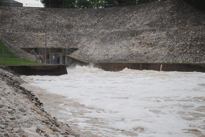
The Corps of Engineers reported that as of 3 p.m. on Tuesday the lake level was at 387.07 feet. The crest was forecast was set for Friday at 394.0 feet – but that was without additional rain. That rain did, indeed, arrive later Tuesday night.
The discharge at the spillway was increased on Tuesday to 10,000 cfs (cubic feet per second). The parking lot at the spillway was busy with visitors stopping to watch the cascade through the reservoir and hear the roar of the water.
At Girl Scout Cove, the water was covered the Holly Huntington Campfire Circle and lapped at the steps on the hillside – approximately 50 yards from the normal waterfront. Gazing out to the water the top12 inches of the flagpole at the Girl Scout waterfront is all that is visable above the water.
“Visitors to the lake are urged to use caution in flash flood-prone areas and when traveling low roads near the lake,” Doug Nichols of the Corps said. “D Highway at Hattie’s Ford floods at elevation 388.0 feet NGVD. All access to the Lake are either flooded or have been closed. Inflows have caused floating debris such as logs, limbs, etc., on the lake. Many recreational facilities are being closed due to this high water.”
For up-to-date lake information and facility closings, call the Wappapello Lake Hotline at (573) 222-8139 or toll-free at 1-877-LAKE-INFO (1-877-525-3463) or call the Wappapello Lake Management Office at (573) 222-8562. The website for the Lake office is www.mvs.usace.army.mil/wappapello.
ShowMe Times Photo Gallery
Last Updated on April 27th 2011 by News
https://showmetimes.com/Blogpost/uija/Record-Levels-Expected-At-Wappapello

