Local News
MoDOT Announces Road Closings
April 25th 2011 by News

BREAKING NEWS
1 p.m., Monday, April 25, 2011
A SMT News Report
SIKESTON, Mo. - The Missouri Department of Transportation District Office in Sikeston at 1 p.m., Monday, April 25 the following roadways in Southeast Missouri are closed to the recent flooding. Several routes have water over them but have not been closed and motorists are urged to use extreme caution and plan alternate routes.
Routes that are closed or have water over the roadways include:
Bollinger County
•· Route 51 - from Castor River to Zalma
•· Route C - from Route BB to Route V
•· Route EE - at Route K near Sedgewickville
•· Route H - from Route 51 to Route FF
•· Route P
•· Route V
•· Route W
Butler County
•· Route 91 - Diversion Channel to Route T
•· Route 53 - from Route 51 to Route 142
•· Route 142
•· Route 158 - from Route BB to Route 142
•· Route BB
•· Route CC
•· Route DD
•· Route HH
•· Route N - near Oglesville from Route 53 to Route 51
•· Route U
•· Route W
•· Route Z
Cape Girardeau County
•· Route N - Intersection of N, U and T to Route F
•· Route OO - from Route Z to Route 34
•· Route P - near Perkins
•· Route P - between Delta and Perkins
•· Route RA
•· Route T - Intersection of N, U and T to Route F
•· Route U - from Route N to Route A Dunklin County
•· Route B - from CRD 322 to Route 62
•· Route DD - from Route 53 to the end of state maintenance
•· Route H - from Route J to Route U
•· Route H south - from Route J to Route 53
•· Route U - from Route U in Stoddard County to County Road 102 in Dunklin County
•· Route WW
Madison County
•· Route F - from Route V to Route A
•· Route V - from Route F to the end of Route F
Mississippi County
•· Route 62 - City of Bertrand
•· Route 75
•· Route 77 - at the Mississippi River
•· Route 77 - from Route DD to Route A
•· Route 80 - from the Mississippi River to Belmont
•· Route 80 West - from I-55 to Route 61
•· Route 102
•· Route A
•· Route AA
•· Route B
•· Route F
•· Route NN - intersection of Routes NN and 62
•· Route OO
•· Route Y
New Madrid County
•· Route 153 - Route D to CRD 794
•· Route 61 - approximately two miles south of Sikeston
•· Route 61 - at County Road 502
•· Route 162 - at the Mississippi River
•· Route AA - at County Road 807
•· Route D - from Route 153 to 2 miles west •· Route E
•· Route FF
•· Route H - from Route D to CRD 794
•· Route P - from Route 61 to Route BB
•· Route V
•· Route WW
Pemiscot County
•· Route 162 - at the Mississippi River
Perry County
•· Route A - from County Road 460 to County Road 444
•· Route E
Scott County
•· Route BB - Intersection of Route Y and Route 114
•· Route CC
•· Route E -from Route N to end of road at Commerce
•· Route EE - from Delta to Chaffee
•· Route HH
•· Route N - from Route D
•· Route P
•· Route Z - from Route 61 to Vanduser
•· Route W - Route P to Oran City limits
Stoddard County
•· Route 114
•· Route A - west of Charter Oak
•· Route AB
•· Route BB
•· Route C
•· Route D - Route 25 to CRD 751
•· Route DD
•· Route E - Route FF/E Junction to Route N/E at Circle City
•· Route F
•· Route FF - east of Dexter and south of Route 60
•· Route H
•· Route J
•· Route K
•· Route MM - from Route U in Stoddard County to County Road 102 in Dunklin County
•· Route N - to Route A
•· Route O - between County Road 309 and County Road 337
•· Route P
•· Route T - from Route 51 to the intersection of Routes T and J
•· Route U - Route H to CRD 667
•· Route V
•· Route WW
•· Route Y - from Route AB to Route Z
•· Route Z - from Route VV to east city limits of Bernie
•· Route Z - west of Route 153
•· Route ZZ
•· Intersection of Route E and N
Wayne County
•· Route 49 - from Mill Spring to Route A Junction
•· Route 143 - near Sam A. Baker State Park entrance
•· Route 143 - from Route 34 to Route 49
•· Route FF - from Route U to Route 67
•· Route TT
•· Route Z
For more information, please contact MoDOT's Customer Service Center toll-free at 1-888-ASK-MODOT (1-888-275-6636) or visit the Traveler Information Map at: http://maps.modot.mo.gov/timi/index.aspx?district=10
Last Updated on April 25th 2011 by News
https://showmetimes.com/Blogpost/uiiq/MoDOT-Announces-Road-Closings
Governor Activates National Guard
April 25th 2011 by News

By Annabeth Miller, ShowMe Times Editor
JEFFERSON CITY, Mo. – Missouri’s governor activated the National Guard to help respond to flooding and threats to levees in Southeast Missouri.
Gov. Jay Nixon today activated the Missouri National Guard to help with response efforts in southern and Southeast Missouri impacted by flooding and threats to levees after recent rains.
"I have directed Maj. General Danner to immediately move Guard units into place where they can best help in protecting health and property," Nixon said. "The Citizen-Soldiers and Airmen of the Missouri National Guard have demonstrated their ability to help with natural disasters numerous times over the years, most recently in the work they did before, during, and after the blizzard and record snowstorm this winter. I have full confidence in the Guard to assist local emergency officials around the state."
Under the Nixon's order, Guard units will be deployed immediately to support local emergency agencies. Nixon has been receiving updated briefings from his emergency management team, including senior officials from the Missouri Department of Public Safety, Missouri National Guard, Missouri State Highway Patrol and State Emergency Management Agency to assess the current weather situation and review the latest forecasts.
The Missouri National Guard will provide assistance to those local officials right away in communities that are experiencing major flooding right now, or which expect to see major flooding this week. Their efforts will include assisting local emergency responders with threats to levees near Poplar Bluff and other communities.
Last Updated on April 25th 2011 by News
https://showmetimes.com/Blogpost/uiip/Governor-Activates-National-Guard
Friends Help Family Rise Above Flood
April 25th 2011 by News
By Annabeth Miller, ShowMe Times Editor
BIRD'S CORNER, Mo. - When storm clouds start looking dark, that’s when you can count on friends and family to help you through.
Janie King knows all about that today – the storm clouds and the rain – and good friends and family.
Janie and her husband Robert live in eastern Stoddard County, on Route Y between Bird’s Corner and Salcedo Road. When she got ready to go to work Monday morning she asked her husband to check to see if she had a clear roadway. The answer was simple: No.
With Sunday’s constant rains, waters continued to rise in eastern Stoddard County. Missouri Department of Transportation crews closed Route Y in the county early Monday morning. Water was over the roadway and more was expected.
Route Y is about as east in Stoddard County as you can go. It connects the community of Salcedo in Scott County to Route AB which goes to Cline's Island. At Cline's Island, you cross the Castor River to continue west in the county.
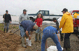
But not long after discovering MoDOT had closed Y, the King family had a bit more to handle. The water was not only over Route Y, it was creeping closer and closer to their grain bins and their home. Family members and friends started moving dirt and chat and filling sandbags to save the grain and the home.
“The first load of sandbags we got had already been filled,” Janie King said at about noon on Monday. “But then they just dropped off loads of sand and empty bags.”
Family members started filling bags and putting them in place. Janie said her daughter has been right in the thick of things, working side-by-side with the grownups.
“She’s the ‘Queen of the Shovel’,” Janie proudly said of her daughter, Liza. Liza is 10 years old, and mom says that she is “not scared of hard work.”
In addition, Janie says neighbors and friends have been lending a helping hand as the water continues to rise and the rain still falls.
“People have been awesome,” she said. “They’ll pull up, stop and get out and start filling sand bags. “
Folks are helping build sandbag walls to keep the floodwater from reaching the grain bins and the family’s home. In addition, another friend has been hauling in loads of chat to help in the effort.
“Kevin McClung of Parma has been bringing chat to build up the driveway to make a barrricade so the water doesn’t come up to our house,” she said.
Janie King is a shutterbug, and in between working with the sandbags, making a big pot of soup for a good lunch for all those working against the rising floodwaters, she has been documenting the day with her camera.
“It’s really something,” King said. “People have just been great.”
Photos courtesy of Janie King
Last Updated on April 25th 2011 by News
https://showmetimes.com/Blogpost/uiio/Friends-Help-Family-Rise-Above-Flood
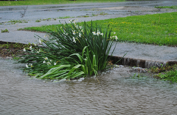
Hail Hits; Flooding Causing Problems In Area
April 25th 2011 by News

By Annabeth Miller, ShowMe Times Editor
Area residents woke up Monday morning after a night filled with additional strong doses of Mother Nature’s wrath – everything from heavy rain, hail, and strong winds.A layer of bright green covered many city streets – green from the young leaves ripped from trees during Sunday night’s hail storm. The hail arrived at approximately 11:10 p.m., leaving behind weather-worn trees, dents in vehicles, and reports of damage to homes and buildings. Reports on the hail measured from pea size to just at one-inch size hail stones.
Dexter City street crews were out early Monday morning cleaning up debris and preparing for the next rainstorm expected Monday afternoon.
In Downtown Dexter, Wayne Jean was busy sweeping the leaves stripped from trees by the overnight hail before business opened. Across Stoddard Street, Tim Holder was preparing for another day of business. He rolled out the carts full of plants – flowers and vegetables. The rainfall has halted work in flower beds and gardens.
“I’m going to run a special,” Holder said with a chuckle. “Ten percent off plants while it’s raining!!”
But the most damage yet may be from the abundance of rain. Local weather watcher Tina Fields reported Monday morning that she has recorded 10.4 inches of rainfall since Thursday night.
Flooding in the region has forced cancellations in the region. The following school districts are closed today because of weather conditions:
• Kelso
• East Carter County
• Greenville
• Poplar Bluff
• Southern Reynolds
• Van Buren
• Zalma
• Advance
• Leopold
• Clearwater
• Woodland
In addition, all campuses of Three Rivers College are closed Monday.
Dexter Public Schools were already scheduled to not be in session on Monday due to the Easter holiday break.
Early Monday morning a mandatory evacuation was ordered for persons living along a stretch of the Black River in Butler County. People living south of the Black River in Butler County and east of Ditch Road should leave their homes. Officials say a level along the Black River has been compromised at County Road 607.
A number of roadways in Stoddard County have been closed due to the recent flooding. Several routes have water over them but have not been closed and motorists are urged to use extreme caution and plan alternate routes.
Routes in Stoddard County that as of 9 a.m. Monday are closed or have water over the roadways include:
•· Route 25 - south of Dexter
•· Route AD
•· Route BB
•· Route D - five miles south of Dexter
•· Route F
•· Route FF - east of Dexter and south of Route 60
•· Route H
•· Route J
•· Route K - from Route BB north to Route BB south
•· Route K - from Route BB south to Route M
•· Route M - from Leora and Routes K and N
•· Route MM - from Route U in Stoddard County to County Road 102 in Dunklin County
•· Route N - to Route A
•· Route O - between County Road 309 and County Road 337
•· Route T - from Route 51 to Route J
•· Route U - six miles west of Bernie
•· Route V
•· Route Y - from Route AB to Route Z
•· Business 60 - Dexter
•· Intersection of Route E and N
Photo Above: Hail pounded the Dexter area late Sunday night, measuring from pea-size to one-inch stones of hail. (SMT Photo by Annabeth Miller)
Last Updated on April 25th 2011 by News
https://showmetimes.com/Blogpost/uiik/Hail-Hits-Flooding-Causing-Problems-In-Area
Rain Continues, T-storms In Forecast
April 23rd 2011 by News
Heavy rains hit just as the Dexter Kiwanis Club Easter Egg Hunt ended Saturday afternoon, and ditches filling and roadways wet and some rain-covered. The National Weather Service calls for thunderstorms to continue throughout the Easter weekend. The forecast calls for storms to continue, with a threat that some of the storms could be severe and produce heavy rainfall. Low Saturday night around 61 and a 80 percent chance of precipitation.
More showers and thunderstorms are expected on Easter Sunday, with a 70 percent chance of precipitation dampening the day.
With the rains continuing through the beginning of the week, the NWS is calling for a Flash Flood Watch and Flood Advisory continuing in the Bootheel.
Last Updated on April 23rd 2011 by News
https://showmetimes.com/Blogpost/uiij/Rain-Continues-Tstorms-In-Forecast

