Local News
Emerson Visits College Health Center
April 22nd 2011 by News
“This is fantastic,” commented Emerson, during a tour of the new labs, classrooms, and high-fidelity simulated patient rooms. “I’m overwhelmed. If I were a nursing student, I’d hope to study in a facility like this.”
Renovations to the 25,000-square-foot facility are complete; the nursing and medical laboratory technology programs began classes on location in January. Surgical Technology and Emergency Medical Services curriculum will follow in August.
“This is one of the greatest ideas you’ve ever had,” Emerson remarked to college president Dr. Devin Stephenson, referencing the partnership between Three Rivers and Poplar Bluff Regional Medical Center that made the new center possible.
PBRMC rents the previously-unused space to the college for approximately one dollar a year. Nursing and allied health students are given the opportunity to study in a functioning hospital setting, and PBRMC recruits heavily from the graduating classes of nurses.
“We’ve maintained a 100 percent post-graduation hiring rate,” said Kim Shackleford, Director of Nursing and Division Chair for Health and Human Services. “Our last class of graduates has a 96 percent first-attempt pass rate for the NCLEX (National Council Licensure Exam for nursing). We anticipate a 100 percent overall pass rate.”
The nursing program at Three Rivers has once again been ranked by Ingram’s Magazine as a top-20 program within Missouri and Kansas, based on enrollment. Three Rivers Nursing is ranked among the University of Missouri, Pittsburg State, the Godfarb School at Barnes Jewish College in St. Louis, and others. Healthcare curriculum is currently being written so that students studying a variety of healthcare disciplines will be required to work with each other in this interactive setting, just as they would is an actual hospital.
“For example,” said Shackleford, “Our EMS students will bring in a ‘patient’ on a stretcher, having already performed their required first-response duties. The ‘patient’ is then checked in and cared for by nursing students, who then have to work with the Medical Lab Technology students to ‘draw blood’ and have it tested.”
“This is a student-focused learning environment,” said nursing instructor Paulette Alexander in conversation with the congresswoman. “Students have to take the lead, and we’re here to help facilitate that interactive experience, which is so crucial to the quality of patient care once they’re working in a true clinical setting.”
“We’re developing some of the first concept-based curriculum in Missouri,” added Shackleford. “We are writing our own textbooks based on our interdisciplinary approach to health science education. We are leaps and bounds ahead of other institutions, and we’re very proud of that.”
“I’ve never seen anything quite as sophisticated as this in my life,” said Emerson. “You have unlimited options here. Three Rivers’ ability to attract some of the best students because of the quality of this facility is unparalleled. I think this is going to succeed beyond anyone’s wildest expectations. Poplar Bluff is the place to be right now.”
Also present for the tour was Poplar Bluff businessman Jerry Murphy, CEO of Gamma Laboratories.
Murphy announced that Gamma Labs would sponsor a scholarship for a Med Lab Tech student starting Fall 2011.
Three Rivers’ MLT program is lead by Dionne Thompson, a former employee of Gamma Labs.
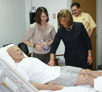
U.S. Rep. Jo Ann Emerson (above) tests out "Hal". a simulation mannequin at the new Nursing and Allied Health Center at Three Rivers College (Teresa Johnson, TRC photo)
Last Updated on April 22nd 2011 by News
https://showmetimes.com/Blogpost/uiie/Emerson-Visits-College-Health-Center
Storm Warnings Issued For Area
April 22nd 2011 by News

A SMT News Report
Southeast Missouri is in the path for another dose of severe weather Friday night and Saturday.
The National Weather Service has issued a Tornado Watch for Stoddard County and much of Southeast Missouri at 5:50 p.m. Friday. The Tornado Watch is in effect until 1 a.m. Saturday.
Counties included in the Tornado Watch include: Bollinger, Butler, Cape Girardeau, Carter, Iron, Madison, Mississippi, Perry, Reynolds, Ripley, Scott, St. Francois, Ste. Genevieve, Stoddard and Wayne counties.
A Tornado Watch means that conditions are favorable for severe thunderstorms capable of producing 1" or larger hail, winds of 58 mph or higher and even tornadoes. Dangerous lightning and heavy downpours are also possible.
In addition, at 4 p.m. Friday the NWS issues a Hazardous Weather Outlook for the region.
The advisory warns of a moderate risk of severe weather in Southeast Missouri for portions of the region north and west of a line from Doniphan to Dexter to Perryville.
“As a cold front approaches this evening, numerous severe thunderstorms are expected to move in the Southeast Missouri and Southern Illinois,” NWS reports. Supercells may be possible in the area with large hail, damaging winds and heavy rainfall the primary concerns. A few tornadoes may be possible as well.
A good chance of thunderstorms continues Saturday through Wednesday along and behind the stalled out frontal boundary. A few periods of severe weather will be possible and flooding will only become more intense with each successive round of thunderstorms.
Last Updated on April 22nd 2011 by News
https://showmetimes.com/Blogpost/uiib/Storm-Warnings-Issued-For-Area
Storms Leave Behind Damage In Parma
April 21st 2011 by News
A SMT News Report
PARMA, Mo. - Tuesday's storms brought some unwelcome consequences in one small New Madrid community.
In the height of Tuesday evening’s storms – at 9:55 p.m. – an unconfirmed twister swept through Parma, leaving behind damage to the City Hall and Community Building.
Parma Chief of Police Trish Cullen reported that a funnel cloud was spotted a few minutes before 10 p.m. on the south end of the community.
“Tree are down and power lines down,” Cullen said Wednesday morning. “Part of the roof at the Community Center and City Hall was damaged.”
The Community Building was not only home for city offices and the place for community gatherings, but was the depository for much of the community’s history. The collection includes photographs from the old Parma school – priceless photos of the community’s past.
But Cullen said that the photos had a crew of “guardians” the night of the storm.
“The police officer on duty got volunteers to come in last night and remove and save all the old high school pictures in the community hall,” saving that piece of community heritage, she said.
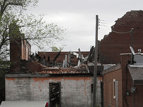
Parma residents and officials are assessing the damage to City Hall and other buildings from Tuesday's storms. The high winds blew off part of the roof on the at the Community Building’/City Hall. In addition, a vacant brick building at the corner of Main and Broadway was among the buildings damaged in the storm.
Photo 1 Above: The old pool hall in downtown Parma was just one of the buildings that suffered damage as a result of the storms in the region Tuesday night.
Photo 2 Above: The Old Shaw Place in Parma suffered damage as the strong winds toss the carport against the house. (Pictures supplied by Daryl Ramsey).
Last Updated on April 21st 2011 by Staff Writer
https://showmetimes.com/Blogpost/uih6/Storms-Leave-Behind-Damage-In-Parma
Storms Blow Through Bootheel
April 20th 2011 by News

By Annabeth Miller, ShowMe Times Editor
Bootheel residents held on tight and road out the storms as tough weather systems made their way across the state.
Most of the damage from the storms was in the northern end of Stoddard County, according the Sheriff Carl Hefner. Hefner said Wednesday morning that there were about three major areas of storm damage and no reported injuries.
“We had a report of a twister south of Puxico but there was no damage reported,” Hefner said.
The Advance area seemed to take hard hits from the storm with tree damage at both the Post Office and elementary school. Hefner said a tree was downed during the storm and damaged a portion of the Advance Post Office. In addition, the sheriff reported a large tree came down on top of an elementary building in Advance.
An unconfirmed twister blew through Parma at about 9:55 p.m. Parma Chief of Police Trish Cullen reported that a funnel cloud was spotted on the south end of the community.
“Tree are down and power lines down,” Cullen said Wednesday morning. “Part of the roof at the Community Center and City Hall was damaged.
“The police officer on duty got volunteers to come in last night and remove and save all the old high school pictures in the community hall,” saving that piece of community heritage, she said.
At the peak of Tuesday night’s storms, Ameren Missouri reports 637 customers were without power. A spokesman for Ameren said the outages were due mostly to two large feeder lines downed by the wind.
“Wind and lightening caused the most problems,” said Mike Cleary of Ameren Missouri’s office in St. Louis. “The peak of outages in Dexter was at 9:30 Tuesday night.”
Cleary said that during the peak of the storm in Southeast Missouri there were approximately 3,800 customers without service. System-wide in Missouri 10,000 customers lost power, primarily in the St. Louis area.
“There was a lot of wind and lightening with these storms,” Cleary said. By 8 a.m. Wednesday morning, less than 700 Ameren customers in the state without power.
Hefner also reported that a building on County Road 690 south of Bernie blew across the road and struck some vehicles. New Clines Island north of Highway 25 in the eastern part of the county a car ran off the road and struck a tree.
In Dexter, there were no reports of major damage in the city and the emergency sirens were not sounded. While the weather system looked ominous on the radar, Dexter escaped much of the storm’s damage.
Other damage in the region reported to the National Weather Service includes:
• Chaffee reported .88 inch hail and wind damage with large trees down on a home in the community.
• Strong gusts of wind was reported along the Mississippi River in both Mississippi and New Madrid counties. The wind was reportedly so strong it moved a vehicle. In addition, dime-size hail was reported in East Prairie.
• Winds estimated between 70 – 75 mph were reported at Marble Hill. Widspread damage was by emergency management staff west and north of the city and most of the damage appear to have been caused by straight line winds with some homes having lost roofs.
Photo Above: A large tree fell Tuesday night at Advance Elementary School during the storms that passed through the region. School officials luckily report minimal damage to the building as a result of the tree slamming into the building; classes went on as scheduled Wednesday morning at Advance. (SMT photo by Andrew Cato)
Last Updated on April 20th 2011 by News
https://showmetimes.com/Blogpost/uigb/Storms-Blow-Through-Bootheel
Metorologists Call For Severe Weather Today
April 19th 2011 by News

UPDATED 11:40 a.m.
By Annabeth Miller, ShowMe Times Editor
If the region hasn’t already had some strong doses of severe weather lately, the National Weather Service is calling for a “significant severe weather event” for Southeast Missouri on Tuesday and Tuesday night.
Meteorologists say a strong low pressure system will move into the region from Western Missouri midday Tuesday. A cold front will approach from the wet late today and move across the region tonight.
“An outbreak of severe thunderstorms is forecast along and ahead of the cold front,” NWS reported. The Storm Prediction Center in Norman, Okla., has place all of Southeast Missouri as well as Southern Illinois in a “moderate risk”” area for severe storms. These storms are expected to include large hail, damaging wind and a “few” tornadoes.
Dexter native Jeff Huffman is the meteorologist KMIZ, the ABC television station in Columbia.Huffman says today may be a busy one for meteorologists in Missouri.
"This year's severe weather season has already been a busier than normal one across much of the nation. We will likely add to the numbers today as another powerful cold front moves across the Midwest. Widespread damaging wind gusts are expected across much of southeastern Missouri this evening, with an isolated tornado or two also possible," he said.
 "The lingering colder than normal weather across the northern states, a pattern typical of the La Nina cycle we are currently in, results in greater than usual temperature contrasts along fronts thus the higher than normal occurrences of severe storms," Huffman said of today's weather warnings. The NWS says the time frame of greatest concern is from the the end of the work day through the first half of tonight. The weather service advises that persons who have plans to be “out and about” today to consider altering those plans and to be proactive in preparing for any severe weather.
Photo Above: Dexter native Jeff Huffman is a meteorologist with KMIZ television in Columbia. Huffman is a 1997 graduate of Dexter High School.
Last Updated on April 19th 2011 by News
https://showmetimes.com/Blogpost/uig8/Metorologists-Call-For-Severe-Weather-Today

