Local News
Storms Blow Through Bootheel
April 20th 2011 by News

By Annabeth Miller, ShowMe Times Editor
Bootheel residents held on tight and road out the storms as tough weather systems made their way across the state.
Most of the damage from the storms was in the northern end of Stoddard County, according the Sheriff Carl Hefner. Hefner said Wednesday morning that there were about three major areas of storm damage and no reported injuries.
“We had a report of a twister south of Puxico but there was no damage reported,” Hefner said.
The Advance area seemed to take hard hits from the storm with tree damage at both the Post Office and elementary school. Hefner said a tree was downed during the storm and damaged a portion of the Advance Post Office. In addition, the sheriff reported a large tree came down on top of an elementary building in Advance.
An unconfirmed twister blew through Parma at about 9:55 p.m. Parma Chief of Police Trish Cullen reported that a funnel cloud was spotted on the south end of the community.
“Tree are down and power lines down,” Cullen said Wednesday morning. “Part of the roof at the Community Center and City Hall was damaged.
“The police officer on duty got volunteers to come in last night and remove and save all the old high school pictures in the community hall,” saving that piece of community heritage, she said.
At the peak of Tuesday night’s storms, Ameren Missouri reports 637 customers were without power. A spokesman for Ameren said the outages were due mostly to two large feeder lines downed by the wind.
“Wind and lightening caused the most problems,” said Mike Cleary of Ameren Missouri’s office in St. Louis. “The peak of outages in Dexter was at 9:30 Tuesday night.”
Cleary said that during the peak of the storm in Southeast Missouri there were approximately 3,800 customers without service. System-wide in Missouri 10,000 customers lost power, primarily in the St. Louis area.
“There was a lot of wind and lightening with these storms,” Cleary said. By 8 a.m. Wednesday morning, less than 700 Ameren customers in the state without power.
Hefner also reported that a building on County Road 690 south of Bernie blew across the road and struck some vehicles. New Clines Island north of Highway 25 in the eastern part of the county a car ran off the road and struck a tree.
In Dexter, there were no reports of major damage in the city and the emergency sirens were not sounded. While the weather system looked ominous on the radar, Dexter escaped much of the storm’s damage.
Other damage in the region reported to the National Weather Service includes:
• Chaffee reported .88 inch hail and wind damage with large trees down on a home in the community.
• Strong gusts of wind was reported along the Mississippi River in both Mississippi and New Madrid counties. The wind was reportedly so strong it moved a vehicle. In addition, dime-size hail was reported in East Prairie.
• Winds estimated between 70 – 75 mph were reported at Marble Hill. Widspread damage was by emergency management staff west and north of the city and most of the damage appear to have been caused by straight line winds with some homes having lost roofs.
Photo Above: A large tree fell Tuesday night at Advance Elementary School during the storms that passed through the region. School officials luckily report minimal damage to the building as a result of the tree slamming into the building; classes went on as scheduled Wednesday morning at Advance. (SMT photo by Andrew Cato)
Last Updated on April 20th 2011 by News
https://showmetimes.com/Blogpost/uigb/Storms-Blow-Through-Bootheel
Metorologists Call For Severe Weather Today
April 19th 2011 by News

UPDATED 11:40 a.m.
By Annabeth Miller, ShowMe Times Editor
If the region hasn’t already had some strong doses of severe weather lately, the National Weather Service is calling for a “significant severe weather event” for Southeast Missouri on Tuesday and Tuesday night.
Meteorologists say a strong low pressure system will move into the region from Western Missouri midday Tuesday. A cold front will approach from the wet late today and move across the region tonight.
“An outbreak of severe thunderstorms is forecast along and ahead of the cold front,” NWS reported. The Storm Prediction Center in Norman, Okla., has place all of Southeast Missouri as well as Southern Illinois in a “moderate risk”” area for severe storms. These storms are expected to include large hail, damaging wind and a “few” tornadoes.
Dexter native Jeff Huffman is the meteorologist KMIZ, the ABC television station in Columbia.Huffman says today may be a busy one for meteorologists in Missouri.
"This year's severe weather season has already been a busier than normal one across much of the nation. We will likely add to the numbers today as another powerful cold front moves across the Midwest. Widespread damaging wind gusts are expected across much of southeastern Missouri this evening, with an isolated tornado or two also possible," he said.
 "The lingering colder than normal weather across the northern states, a pattern typical of the La Nina cycle we are currently in, results in greater than usual temperature contrasts along fronts thus the higher than normal occurrences of severe storms," Huffman said of today's weather warnings. The NWS says the time frame of greatest concern is from the the end of the work day through the first half of tonight. The weather service advises that persons who have plans to be “out and about” today to consider altering those plans and to be proactive in preparing for any severe weather.
Photo Above: Dexter native Jeff Huffman is a meteorologist with KMIZ television in Columbia. Huffman is a 1997 graduate of Dexter High School.
Last Updated on April 19th 2011 by News
https://showmetimes.com/Blogpost/uig8/Metorologists-Call-For-Severe-Weather-Today
Council Discusses Downtown Parking
April 19th 2011 by News

By Annabeth Miller
ShowMe Times Editor
Parking. A business district has to have parking available for shoppers and visitors. But what happens when vehicles stay in the same parking spot for hours on end – limiting the parking available for more shoppers and visitors.
It’s like a circle with no end.
Parking in the downtown district was a topic of conversation Monday evening at meeting of the Dexter Board of Aldermen. City Administrator Mark Stidham explained that some merchants have in the past made complaints about long-term parking in the downtown district, and that he and Police Chief Sammy Stone were studying the issue.
“It’s an ongoing issues – we know that,” Stidham said. One suggestion Stidham offered to aldermen was to make a stretch of Stoddard Street limited to two hours parking in a spot. The proposed area could possible stretch on Stoddard Street from Catalpa to Poplar.
“I think we should do something,” said Ward 2 Alderman Dr. Rick Hux. Also was presiding at Monday’s meeting as the President of the Board of Aldermen in the absence of Mayor Joe Weber. “I would like to have input from the citizens and see how they feel. I definitely feel it is something we need to consider.”
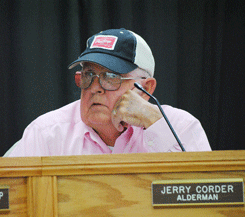
During Committee Reports, Ward 1 Alderman Jerry Corder suggested that additional signs are needed for the new Dexter Welcome Center at the Depot in the downtown district.
“The sign that is there in front is wonderful, but I think there needs to be something there on Walnut Street,” Corder commented. He suggested smaller signs visible on Walnut directing visitors to the new center.
The city will be hosting an Open House at the New Dexter Welcome Center from 1-4 p.m. on Sunday, May 1. The public is invited to visit the newly renovated Depot.
The Public Safety Committee met prior to the Board, and recommended the appointment of Stephanie Credille as a fulltime dispatcher for the Police Department.
Hux, as the president of the board, agreed with the committee and appointed Credile to the position. The board unanimously confirmed her appointment.
Also on the recommendation of the committee, Hux appointed Jeff Hueckel as a paid on-call member of the Dexter Fire Department. His appointment was also unanimously confirmed by the board.
Parks and Recreation Department Lawson Metcalf reported that the Dexter Aquatic Center has been filled with water and it has been chemically treated in preparation for the summer season. In fact, Metcalf reported a lifeguarding class had its first lesson Monday evening at the complex.
“The water is 58 degrees tonight,” he reported, bringing many to shivers in the room.
In other business Monday, the board:
• Received a report from Water superintendent Tom Espy that work was underway on the construction of the new lift station on Fairground Road;
• Was informed by Library Director Pam Trammell that Dexter will host the Southeast Missouri Library Directors meeting on April 26;
• Confirmed the reappointment of Greg Mathis to a new four-year term on the Cemetery Board; and Pat Miller, Tracey Elfrink and Ben Worley to new two-year terms on the Parks and Recreation Board.
The next regular meeting of the Dexter Board of Aldermen is scheduled for Monday, May 2.
Photo Above: Ward 1 Alderman Jerry Corder discussed signs directing travelers to the Dexter Welcome Center at Monday's meeting of the Dexter Board of Aldermen.
Last Updated on April 19th 2011 by News
https://showmetimes.com/Blogpost/uig5/Council-Discusses-Downtown-Parking
Catron Man Killed In Morning Accident
April 18th 2011 by News

A ShowMe Times Report
An accident early Monday morning has claimed the life of a Catron man.
The Missouri State Highway Patrol reports that Jonithan L. Dodson, 37, of Catron was in a 1995 Jeep heading north on Highway 153, five miles east of Bernie at about 6:30 a.m. A 2007 Pontiac eastbound and driven by Holly L. Pruitt, 19, of Lilbourn pulled out in front of the Dodson vehicle near the Route Z intersection.
Both vehicles ran off the roadway, and the Dodson vehicle overturned in a nearby ditch.
Pruitt suffered moderate injuries and was taken by ambulance to Southeast Medical Center in Cape Girardeau.
Dodson was pronounced dead at the scene by Stoddard County Coroner Aaron Mathis.
The Highway Patrol reports Dodson was not wearing a seat belt.
Last Updated on April 18th 2011 by News
https://showmetimes.com/Blogpost/uig0/Catron-Man-Killed-In-Morning-Accident
The Worst Of Spring Storms Yet To Come
April 18th 2011 by News

By Annabeth Miller, ShowMe Times Editor
Southeast Missourians may think we have seen some turbulent weather already this spring – but the bad news is that “it ain’t over yet.”A weather expert with the University of Missouri says that this spring could be stormer than normal. Tony Lupo with the College of Agriculture, Food and Natural Resources in Columbia, says that our spring weather will be affected by La Nina, the same phenomenon that spawned this winter’s snows and ice.
The Midwest found out just how forceful La Nina can be this last weekend. Friday afternoon brought tornado watches, hail and heavy storms throughout Southeast Missouri. Throughout the weekend a deadly swarm of twisters left devastation in up to 15 states.
Storms threatened most of Friday afternoon in the Deter area, and pea-size hail fell at approximately 4:30 p.m. The entire region was under a Tornado Watch until 9 p.m. Friday
The storms storms battered their way from Oklahoma to North Carolina, claiming at least 44 lives, almost half of those in North Carolina. It was the deadliest since Feb. 5, 2008, when 57 died in the "Super Tuesday" election day tornadoes in the Southeast. And that was the highest tornado death toll since 76 died in 1985.
La Niña occurs when cooler than normal water temperatures develop in the Equatorial Pacific Ocean. Lupo thinks La Niña will lead to increased spring and summer thunderstorm activity in states north of Tornado Alley, including Nebraska, Iowa, northern Illinois and Indiana.
Tornado Alley is defined as North Texas, Oklahoma and Kansas. Lupo says that La Niña tends to shift the jet stream patterns northward over the U.S.
In a La Niña season, the jet streams pick up warm Pacific moisture and direct warm and unstable air to Nebraska, Iowa, Illinois and Indiana. Storm systems and fronts tend to follow these streams.
Overall, from Thursday through Saturday, there were reports of funnel clouds in Kansas, Oklahoma, Texas, Arkansas, Alabama, Illinois, Missouri, Mississippi, Kentucky, Georgia, Louisiana, Maryland, Virginia, North Carolina and South Carolina.
“For a thunderstorm to develop, there must be moisture and warm air,” Lupo says. “When the jet stream is farther north, as it is in a La Niña event, you have a better chance of achieving these kinds of temperatures and dew points in these parts of the country.”
In Tornado Alley, Lupo forecasts a relatively calm year. Atmospheric models predict a dryer than normal spring and summer, taking away the fuel for supercell storms, which often spawn tornadoes.
Last Updated on April 18th 2011 by News
https://showmetimes.com/Blogpost/uifv/The-Worst-Of-Spring-Storms-Yet-To-Come

