Stoddard County, MO - The National Weather Service in Paducah, KY has issued a Special Weather Statement for Stoddard County, Missouri.
Description
...HEAT INDEX VALUES FROM 100 TO 105 DEGREES THIS AFTERNOON...
Temperatures will soar into the 90s by midday and into the afternoon hours. With elevated humidity levels in place, this will result in afternoon heat index values from 100 to 105.
Take it easy if you must be outside today. Young children and pets should never be left unattended in vehicles under any circumstances.

Stoddard County, MO - The National Weather Service in Paducah, KY has issued a Lake Wind Advisory until 7 p.m. this evening. The Wind Advisory has been cancelled.
Affected Area
Portions of southeast Missouri, western Kentucky and southern Illinois
Description
...LAKE WIND ADVISORY IN EFFECT UNTIL 7 PM CDT THIS EVENING... ...WIND ADVISORY IS CANCELLED...
WHAT...Southwest winds becoming northwest 10 to 20 mph with gusts of 30 to 35 mph.
WHERE...Portions of southeast Missouri, western Kentucky and southern Illinois.
WHEN...Until 7 PM CDT this evening.
IMPACTS...Strong winds and rough waves on area lakes will create hazardous conditions for small craft.
PRECAUTIONARY/PREPAREDNESS ACTIONS...
Boaters on area lakes should use extra caution since strong winds and rough waves can overturn small craft.

Stoddard County, MO - The National Weather Service in Paducah, KY has issued at Flash Flood Watch.
Description
...FLASH FLOOD WATCH REMAINS IN EFFECT FROM 1 PM CDT THIS AFTERNOON THROUGH THURSDAY EVENING...
The Flash Flood Watch continues for
Portions of southern Illinois...southwest Indiana...western Kentucky and southeast Missouri, including the following areas, in southern Illinois, Alexander, Edwards, Franklin, Gallatin, Hamilton, Hardin, Jackson, Jefferson, Johnson, Massac, Perry IL, Pope, Pulaski, Saline, Union, Wabash, Wayne IL, White and Williamson. In southwest Indiana, Gibson, Pike, Posey, Spencer, Vanderburgh and Warrick. In western Kentucky, Ballard, Carlisle, Crittenden, Daviess, Henderson, Livingston, McCracken, McLean, Union KY and Webster. In southeast Missouri, Bollinger, Butler, Cape Girardeau, Carter, Mississippi, New Madrid, Perry MO, Ripley, Scott, Stoddard and Wayne MO.
From 1 PM CDT this afternoon through Thursday evening
There will be the potential for several rounds of moderate to heavy rainfall this afternoon through Thursday evening. Rainfall totals of 2 to 4 inches will be possible. Locally higher amounts cannot be ruled out. This watch is generally in effect for locations north of a line extending from Doniphan, Missouri to Paducah, Kentucky to Calhoun, Kentucky.
In addition to the flash flood potential of urban and rural areas, main stem rivers may also be affected out in time.
PRECAUTIONARY/PREPAREDNESS ACTIONS...
Do not attempt to drive across water covered roads. If you come upon a flooded road, turn around and find an alternate route.

Stoddard County, MO - The National Weather Service in Paducah, KY has issued a Special Weather Statement for Stoddard County, MO.
...Southerly Wind Gusts near 35 MPH this Afternoon...
For residents and travelers across southeast Missouri and southern Illinois, look for occasional gusts near 35 mph. A few locations, especially in southern Illinois, may even see gusts to 40 mph.
These gusts may cause difficulty for those driving on west to east oriented roadways with high profile vehicles. Some loose objects left outdoors may be tossed around.
In addition, if you are traveling out on area lakes and rivers, be watchful for the development of choppy waves and whitecaps on the water. This may impact your ability to control your watercraft safely.
The greatest likelihood of seeing gusty winds in excess of 35 mph will be from Noon through 5 PM CDT today. The winds should gradually diminish toward sunset.
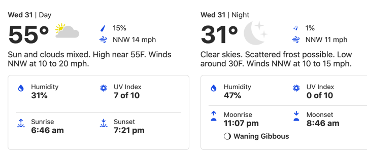
Stoddard County, MO - The National Weather Service in Paducah, Kentucky has issued a Frost Advisory for Stoddard County from 11 p.m. Wednesday evening to 9 a.m. Thursday morning.
Affected Area
For the Freeze Warning, southwestern Indiana, southeastern Missouri, southern Illinois, and western Kentucky, except for most of the Pennyrile region and eastern parts of the Purchase area. For the Frost Advisory, the entire region
Description
...FREEZE WARNING REMAINS IN EFFECT UNTIL 9 AM CDT THIS MORNING... ...FROST ADVISORY IN EFFECT FROM 11 PM THIS EVENING TO 9 AM CDT THURSDAY...
WHAT...For the Freeze Warning, sub-freezing temperatures as low as 29 degrees. For the Frost Advisory, temperatures as low as 31 will result in frost formation.
WHERE...For the Freeze Warning, southwestern Indiana, southeastern Missouri, southern Illinois, and western Kentucky, except for most of the Pennyrile region and eastern parts of the Purchase area. For the Frost Advisory, the entire region.
WHEN...For the Freeze Warning, until 9 AM CDT this morning. For the Frost Advisory, from 11 PM this evening to 9 AM CDT Thursday.
IMPACTS...Frost and freeze conditions will kill crops, other sensitive vegetation and possibly damage unprotected outdoor plumbing.
PRECAUTIONARY/PREPAREDNESS ACTIONS...
Take steps now to protect tender plants from the cold. To prevent freezing and possible bursting of outdoor water pipes they should be wrapped, drained, or allowed to drip slowly. Those that have in-ground sprinkler systems should drain them and cover above- ground pipes to protect them from freezing.

Stoddard County, MO - The National Weather Service has issued a FREEZE WARNING for Stoddard County, MO from 1 a.m. - 9 a.m. Wednesday morning. Weather provided by Bagby Wealth Management.
Affected Area
In Missouri, Butler, Stoddard and Scott Counties. In Illinois, Gallatin, Johnson, Pope, Hardin, Alexander, Pulaski and Massac Counties
Description
...FREEZE WARNING IN EFFECT FROM 1 AM TO 9 AM CDT WEDNESDAY..
WHAT...Sub-freezing temperatures as low as 30 degrees are expected.
WHERE...In Missouri, Butler, Stoddard and Scott Counties. In Illinois, Gallatin, Johnson, Pope, Hardin, Alexander, Pulaski and Massac Counties.
WHEN...From 1 AM to 9 AM CDT Wednesday.
IMPACTS...Frost and freeze conditions will kill crops, other sensitive vegetation and possibly damage unprotected outdoor plumbing.
PRECAUTIONARY/PREPAREDNESS ACTIONS...
Take steps now to protect tender plants from the cold. To prevent freezing and possible bursting of outdoor water pipes they should be wrapped, drained, or allowed to drip slowly. Those that have in-ground sprinkler systems should drain them and cover above- ground pipes to protect them from freezing.